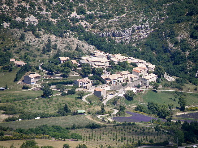
Vercoiran (Vercoiran)

- коммуна во Франции
 Hiking in Vercoiran
Vercoiran is a charming commune located in the Drôme department in southeastern France, known for its beautiful natural landscapes and outdoor activities, including hiking. The region offers various trails that cater to different levels of hikers, from beginners to more experienced outdoor enthusiasts.
Hiking Trails
-
Les Gorges de la Gervanne: This scenic trail takes you through stunning gorges and offers breathtaking views of the surrounding cliffs and valleys. The route is generally moderate and showcases the area's diverse flora and fauna.
-
Serre de Montchenu: A popular trail for those looking to enjoy panoramic views. The hike to the summit provides a rewarding vista over the Vercors and Drôme Provençale regions. It's a moderately challenging hike, ideal for those who are in good physical condition.
-
La Côte de Vercoiran to Rousset: This trail offers a unique combination of history and nature, where hikers can explore the local wildlife and enjoy views of the picturesque landscapes. The trail is fairly easy and suitable for families.
Trail Considerations
- Season: The best time to hike in this region is during the spring and fall when the weather is mild, and the natural scenery is at its finest. Summer can get quite hot, while winter may bring snow to higher elevations.
- Preparation: Always check the trail conditions before setting out, carry enough water and snacks, wear appropriate footwear, and consider using a map or GPS device.
- Wildlife: Keep an eye out for the local wildlife, including various bird species and possibly even deer. Respect their habitat and be mindful of your surroundings.
Outdoor Activities
In addition to hiking, the area surrounding Vercoiran also offers opportunities for biking, climbing, and even swimming in nearby rivers during the summer months.
Conclusion
Vercoiran's hiking trails provide a wonderful way to experience the natural beauty and tranquility of the Drôme region. Whether you're looking for a leisurely walk or a more challenging hike, you'll find a trail that suits your preferences. Enjoy your hiking adventure!
- Страна:

- Почтовый код: 26170
- Координаты: 44° 18' 3" N, 5° 20' 45" E


- GPS треки (wikiloc): [Ссылка]
- Площадь: 19.95 кв.км
- Население: 144
- Википедия английская: wiki(en)
- Википедия национальная: wiki(fr)
- Хранилище Wikidata: Wikidata: Q314635
- Катеория в википедии: [Ссылка]
- код Freebase: [/m/03mhlxy]
- код GeoNames: Альт: [2970001]
- номер SIREN: [212603708]
- код BNF: [15253230f]
- код VIAF: Альт: [307312116]
- код Pleiades: [167963]
- код Trismegistos: [20954]
- код муниципалитета INSEE: 26370
Граничит с регионами:

La Rochette-du-Buis
- коммуна во Франции
Hiking in La Rochette-du-Buis
La Rochette-du-Buis is a picturesque village located in the Drôme department of France, part of the Auvergne-Rhône-Alpes region. It is surrounded by stunning natural landscapes, making it an ideal location for hiking enthusiasts....
- Страна:
- Почтовый код: 26170
- Координаты: 44° 16' 9" N, 5° 25' 13" E
- GPS треки (wikiloc): [Ссылка]
- Площадь: 10.36 кв.км
- Население: 78


La Roche-sur-le-Buis
- коммуна во Франции
Hiking in La Roche-sur-le-Buis
La Roche-sur-le-Buis is a charming commune located in the Vaucluse department of southeastern France, nestled in the scenic landscapes of the Drôme Provençale region. It’s a lesser-known destination for hikers, but it offers an array of beautiful trails and natural sites that are perfect for outdoor enthusiasts....
- Страна:
- Почтовый код: 26170
- Координаты: 44° 16' 37" N, 5° 18' 44" E
- GPS треки (wikiloc): [Ссылка]
- Площадь: 27.72 кв.км
- Население: 295

Saint-Sauveur-Gouvernet
- коммуна во Франции
Hiking in Saint-Sauveur-Gouvernet
Saint-Sauveur-Gouvernet is a charming commune located in the Auvergne-Rhône-Alpes region of France. It is known for its beautiful natural surroundings, making it an excellent destination for hiking enthusiasts. Here are some highlights about hiking in and around Saint-Sauveur-Gouvernet:...
- Страна:
- Почтовый код: 26110
- Координаты: 44° 20' 14" N, 5° 21' 3" E
- GPS треки (wikiloc): [Ссылка]
- Площадь: 19.32 кв.км
- Население: 184


Buis-les-Baronnies
- коммуна во Франции
Hiking in Buis-les-Baronnies
Buis-les-Baronnies, located in the Drome department of southeastern France, is a fantastic destination for hiking enthusiasts. Nestled in the picturesque Baronnies region, the area boasts diverse landscapes, varying altitudes, and a mild Mediterranean climate, making it ideal for outdoor activities....
- Страна:
- Почтовый код: 26170
- Координаты: 44° 16' 31" N, 5° 16' 28" E
- GPS треки (wikiloc): [Ссылка]
- Площадь: 33.74 кв.км
- Население: 2287
- Веб сайт: [Ссылка]


Sainte-Euphémie-sur-Ouvèze
- коммуна во Франции
Hiking in Sainte-Euphémie-sur-Ouvèze
Sainte-Euphémie-sur-Ouvèze is a quaint village located in the Vaucluse department in the Provence-Alpes-Côte d'Azur region of southeastern France. Nestled within the picturesque landscape of the foothills of the Mont Ventoux, it offers a variety of hiking opportunities for outdoor enthusiasts....
- Страна:
- Почтовый код: 26170
- Координаты: 44° 18' 2" N, 5° 22' 46" E
- GPS треки (wikiloc): [Ссылка]
- Площадь: 11.28 кв.км
- Население: 72


Bésignan
- коммуна во Франции
Hiking in Bésignan
Bésignan is a small, picturesque village located in the Drôme department of southeastern France. Nestled in the foothills of the Vercors Mountains, it offers a range of beautiful hiking opportunities for outdoor enthusiasts....
- Страна:
- Почтовый код: 26110
- Координаты: 44° 19' 13" N, 5° 19' 31" E
- GPS треки (wikiloc): [Ссылка]
- Площадь: 8.94 кв.км
- Население: 70