canton of Saint-Laurent-du-Pont (canton de Saint-Laurent-du-Pont)
 Hiking in canton of Saint-Laurent-du-Pont
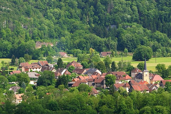
Canton de Saint-Laurent-du-Pont, located in the Auvergne-Rhône-Alpes region of France, is a beautiful area known for its stunning landscapes and hiking opportunities. The region is adorned with picturesque mountains, lush forests, and charming villages, making it an excellent destination for outdoor enthusiasts.
Hiking Highlights
-
Natural Beauty: The area offers breathtaking views, particularly of the Chartreuse Mountains. The rich biodiversity and varied terrain include rocky paths, rolling hills, and secluded valleys.
-
Trails: There are several well-marked hiking trails in and around the Canton de Saint-Laurent-du-Pont. Popular routes include:
- Le Sommet de la Dent de Crolles: A moderately challenging hike that rewards you with panoramic views from the summit.
- Le Grand Som: Ideal for experienced hikers, this trail provides a more strenuous hike with beautiful vistas.
-
Lac de la Chartreuse: This scenic lake area offers milder hiking options and is ideal for family outings. The trails around the lake are suitable for walkers of all skill levels.
-
Flora and Fauna: Hikers can enjoy the local wildlife and a variety of plant species, particularly in the protected areas of the Chartreuse Regional Natural Park. Keep an eye out for native birds and other wildlife.
-
Cultural Sites: Along the trails, you may come across historical sites, including ancient ruins and traditional Alpine architecture. These add a cultural dimension to your hiking experience.
Tips for Hiking in Canton de Saint-Laurent-du-Pont
- Weather: Always check the weather forecast before setting off. The region's weather can be unpredictable, especially in higher altitudes.
- Safety: Carry sufficient water, snacks, and a first aid kit. Inform someone about your hiking plans, especially if you are going solo.
- Footwear: Good hiking boots are essential due to uneven terrain and rocky paths.
- Local Regulations: Respect local wildlife and follow the guidelines of national parks to preserve the natural beauty of the area.
Best Time to Visit
The best time to hike in this region is typically between late spring and early autumn (May to September), when the weather is generally mild and the trails are more accessible.
In summary, Canton de Saint-Laurent-du-Pont provides a diverse range of hiking experiences suited for all levels. With its stunning natural landscapes and rich cultural history, it's an ideal location for both casual walkers and seasoned hikers.
- Страна:

- Столица: Сен-Лоран-дю-Пон
- Координаты: 45° 23' 0" N, 5° 44' 0" E


- GPS треки (wikiloc): [Ссылка]
- Хранилище Wikidata: Wikidata: Q917168
- код кантона INSEE: [3829]
Включает регионы:

Сен-Кристоф-сюр-Гьер
- коммуна во Франции
Hiking in Сен-Кристоф-сюр-Гьер
Saint-Christophe-sur-Guiers is a charming village located in the Isère department of the Auvergne-Rhône-Alpes region in southeastern France. The area is surrounded by stunning natural landscapes, making it a great destination for hiking enthusiasts....
- Страна:
- Почтовый код: 38380
- Координаты: 45° 26' 19" N, 5° 46' 26" E
- GPS треки (wikiloc): [Ссылка]
- Площадь: 23.54 кв.км
- Население: 858
- Веб сайт: [Ссылка]


Антр-дё-Гье
- коммуна во Франции
Hiking in Антр-дё-Гье
Entre-deux-Guiers, located in the Isère department of the Auvergne-Rhône-Alpes region in France, is a fantastic hiking destination. The area is known for its beautiful landscapes, characterized by beautiful mountains, lush valleys, and varied terrain. Here are some highlights for hiking in this region:...
- Страна:
- Почтовый код: 38380
- Координаты: 45° 25' 56" N, 5° 45' 0" E
- GPS треки (wikiloc): [Ссылка]
- Площадь: 10.55 кв.км
- Население: 1699
- Веб сайт: [Ссылка]


Мирибель-лез-Эшель
- коммуна во Франции
Hiking in Мирибель-лез-Эшель
Miribel-les-Échelles is a charming village located in the Isère department of the Auvergne-Rhône-Alpes region in southeastern France. It is nestled in the foothills of the Chartreuse Mountains, providing a stunning backdrop for various outdoor activities, including hiking....
- Страна:
- Почтовый код: 38380
- Координаты: 45° 25' 45" N, 5° 42' 30" E
- GPS треки (wikiloc): [Ссылка]
- Площадь: 29.34 кв.км
- Население: 1720


Сен-Пьер-д'Антремон
- коммуна во Франции
Hiking in Сен-Пьер-д'Антремон
Saint-Pierre-d'Entremont, located in the Isère department of the Auvergne-Rhône-Alpes region in France, is a picturesque village surrounded by the Chartreuse mountains. It offers a variety of hiking opportunities that cater to different skill levels and preferences. Here are some highlights of hiking in this beautiful area:...
- Страна:
- Почтовый код: 73670
- Координаты: 45° 24' 55" N, 5° 51' 14" E
- GPS треки (wikiloc): [Ссылка]
- Площадь: 32.31 кв.км
- Население: 557
- Веб сайт: [Ссылка]


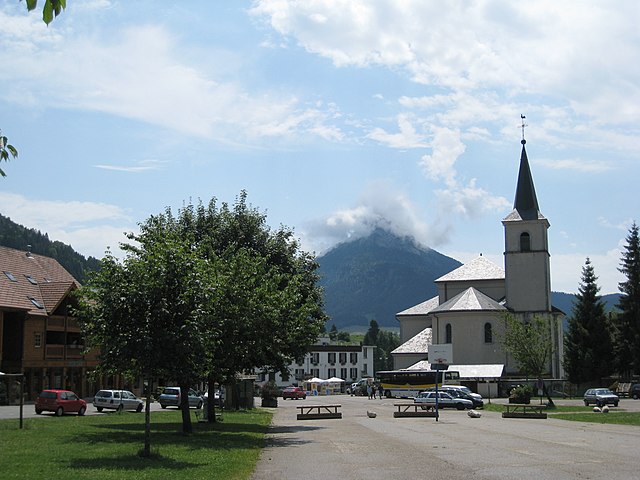
Сен-Лоран-дю-Пон
- коммуна во Франции
Hiking in Сен-Лоран-дю-Пон
Saint-Laurent-du-Pont is a charming commune located in the Isère department of the Auvergne-Rhône-Alpes region in France. It is surrounded by stunning natural landscapes, including the Chartreuse Mountains, making it an excellent destination for hiking enthusiasts....
- Страна:
- Почтовый код: 38380
- Координаты: 45° 23' 15" N, 5° 44' 5" E
- GPS треки (wikiloc): [Ссылка]
- Площадь: 35.25 кв.км
- Население: 4543
- Веб сайт: [Ссылка]

Сен-Пьер-де-Шартрёз
- коммуна во Франции
Hiking in Сен-Пьер-де-Шартрёз
Saint-Pierre-de-Chartreuse is a picturesque village located in the Chartreuse Mountains, in the Auvergne-Rhône-Alpes region of France. It's a popular destination for outdoor enthusiasts, particularly hikers, due to its stunning landscapes, diverse trails, and rich natural heritage. Here are some highlights and tips for hiking in this beautiful area:...
- Страна:
- Почтовый код: 38380
- Координаты: 45° 20' 33" N, 5° 48' 56" E
- GPS треки (wikiloc): [Ссылка]
- Площадь: 80.12 кв.км
- Население: 1028
- Веб сайт: [Ссылка]


Сен-Жозеф-де-Ривьер
- коммуна во Франции
Hiking in Сен-Жозеф-де-Ривьер
Saint-Joseph-de-Rivière is a charming village located in the Isère department in the Auvergne-Rhône-Alpes region of France. This area is surrounded by beautiful natural landscapes, making it an appealing destination for hiking enthusiasts....
- Страна:
- Почтовый код: 38134
- Координаты: 45° 22' 33" N, 5° 41' 49" E
- GPS треки (wikiloc): [Ссылка]
- Площадь: 17.39 кв.км
- Население: 1218
- Веб сайт: [Ссылка]