canton of Virieu (canton de Virieu)
 Hiking in canton of Virieu
Canton de Virieu, located in the Isère department in the Auvergne-Rhône-Alpes region of France, offers a variety of hiking opportunities set against a backdrop of stunning natural scenery. The landscape is characterized by rolling hills, lush forests, and beautiful valleys, making it a fantastic destination for hikers of all skill levels.
Hiking Trails
-
Le Mont Pelé: A popular hiking destination, offering panoramic views of the surrounding area. The trail is well-marked and varies in difficulty, making it suitable for both beginners and experienced hikers.
-
The Vals du Dauphiné: This area features several trails that wind through charming villages and along rivers, providing opportunities to experience local culture and history while enjoying nature.
-
Les Écrins National Park Access: For more adventurous hikers, there are routes that connect to the Écrins National Park where challenging hikes with breathtaking alpine scenery can be found.
Tips for Hiking in Canton de Virieu
- Maps and Guides: Always have a reliable map or hiking guide with you, as some trails may not be well signposted.
- Weather Preparedness: The weather can change rapidly in mountainous areas, so wear layers and bring necessary gear.
- Local Wildlife: Be aware of the local wildlife and practice “leave no trace” principles to preserve the natural environment.
- Hydration and Snacks: Bring enough water and some snacks to keep your energy up during your hikes.
Best Time to Hike
The best time to hike in Canton de Virieu is during the spring and early fall when temperatures are mild, and the landscapes are vibrant with wildflowers or autumn colors. Summer can be warmer, while winter may have snow, making certain trails more challenging.
Accessibility
Canton de Virieu is accessible by road, and there are various entry points to hiking trails. Public transport options may vary, so it's advisable to check local services if you plan on using them.
Whether you're looking for a leisurely walk with family or a challenging trek, Canton de Virieu has something for everyone to enjoy in the great outdoors.
- Страна:

- Столица: Вирьё
- Координаты: 45° 28' 53" N, 5° 29' 18" E


- GPS треки (wikiloc): [Ссылка]
- Хранилище Wikidata: Wikidata: Q1727943
- код кантона INSEE: [3843]
Включает регионы:


Шаравин
- коммуна во Франции
Hiking in Шаравин
Charavines is a picturesque village located in the Isère department of the Auvergne-Rhône-Alpes region in southeastern France. Nestled near the shores of Lake Paladru, it offers a variety of hiking opportunities suitable for all levels of outdoor enthusiasts. Here are some highlights of hiking in and around Charavines:...
- Страна:
- Почтовый код: 38850
- Координаты: 45° 25' 50" N, 5° 30' 48" E
- GPS треки (wikiloc): [Ссылка]
- Площадь: 7.52 кв.км
- Население: 1907
- Веб сайт: [Ссылка]


Дуассен
- коммуна во Франции
Hiking in Дуассен
Doissin, located in the Auvergne-Rhône-Alpes region of France, is a beautiful spot for hiking enthusiasts. The area is characterized by its picturesque landscapes, including rolling hills, forests, and scenic viewpoints....
- Страна:
- Почтовый код: 38730
- Координаты: 45° 29' 59" N, 5° 25' 25" E
- GPS треки (wikiloc): [Ссылка]
- Площадь: 8.45 кв.км
- Население: 891
- Веб сайт: [Ссылка]

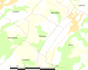
Бланден
- коммуна во Франции
Hiking in Бланден
Blandin, located in Minnesota, is known for its beautiful landscapes and outdoor recreational opportunities, including hiking. The area offers a variety of trails suited for different skill levels and preferences, ranging from leisurely walks to more challenging hikes....
- Страна:
- Почтовый код: 38730
- Координаты: 45° 28' 11" N, 5° 26' 53" E
- GPS треки (wikiloc): [Ссылка]
- Площадь: 4.26 кв.км
- Население: 141


Вирьё
- коммуна во Франции
Hiking in Вирьё
Virieu is a charming commune located in the Auvergne-Rhône-Alpes region of France. It's surrounded by picturesque landscapes, making it an excellent destination for hiking enthusiasts. Here are some key aspects of hiking in Virieu:...
- Страна:
- Почтовый код: 38730
- Координаты: 45° 29' 8" N, 5° 28' 32" E
- GPS треки (wikiloc): [Ссылка]
- Площадь: 11.38 кв.км
- Население: 1110
- Веб сайт: [Ссылка]


Валанконь
- коммуна во Франции
Hiking in Валанконь
Valencogne is a lesser-known but beautiful destination for hiking, located in the French Alps. Here are some highlights and tips for hiking in this area:...
- Страна:
- Почтовый код: 38730
- Координаты: 45° 29' 57" N, 5° 32' 24" E
- GPS треки (wikiloc): [Ссылка]
- Площадь: 7.55 кв.км
- Население: 662
- Веб сайт: [Ссылка]


Сент-Ондра
- коммуна во Франции
Hiking in Сент-Ондра
Saint-Ondras is a small commune located in the Isère department in the Auvergne-Rhône-Alpes region of France. While it may not be as well-known for hiking as some other areas in the region, it offers opportunities for outdoor enthusiasts seeking beautiful landscapes and tranquility....
- Страна:
- Почтовый код: 38490
- Координаты: 45° 31' 4" N, 5° 32' 49" E
- GPS треки (wikiloc): [Ссылка]
- Площадь: 8.15 кв.км
- Население: 621


Ле-Пен
Hiking in Ле-Пен
Le Pin, located in the Isère department of the Auvergne-Rhône-Alpes region in France, offers beautiful hiking opportunities with picturesque landscapes and a variety of trails suited for different skill levels. Here are some insights into hiking in the area:...
- Страна:
- Почтовый код: 38730
- Координаты: 45° 27' 24" N, 5° 30' 20" E
- GPS треки (wikiloc): [Ссылка]
- Площадь: 9.6 кв.км
- Население: 1255
- Веб сайт: [Ссылка]

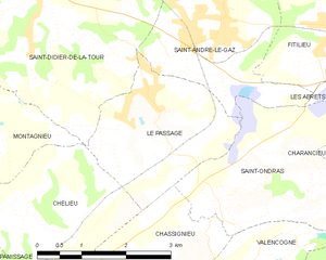
Ле-Пассаж
- коммуна во Франции
Hiking in Ле-Пассаж
Le Passage is a small village located in the Isère department of the Auvergne-Rhône-Alpes region in southeastern France. While it may not be as widely recognized as some larger hiking destinations, the surrounding Isère region offers a wealth of hiking opportunities, particularly in the nearby Vercors and Chartreuse mountain ranges....
- Страна:
- Почтовый код: 38490
- Координаты: 45° 31' 58" N, 5° 30' 43" E
- GPS треки (wikiloc): [Ссылка]
- Площадь: 6.68 кв.км
- Население: 783
- Веб сайт: [Ссылка]


Уайё
- коммуна во Франции
Hiking in Уайё
Oyeu is a charming municipality located in the Auvergne-Rhône-Alpes region of France, known for its picturesque landscapes and outdoor activities, including hiking. Although Oyeu might not be as famous as some larger hiking destinations, it offers a range of trails that cater to various skill levels and preferences....
- Страна:
- Почтовый код: 38690
- Координаты: 45° 25' 19" N, 5° 28' 28" E
- GPS треки (wikiloc): [Ссылка]
- Площадь: 13.69 кв.км
- Население: 956
- Веб сайт: [Ссылка]

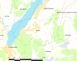
Бильё
- коммуна во Франции
Hiking in Бильё
Bilieu is a charming village located in the Auvergne-Rhône-Alpes region of France, near the shores of Lake Paladru. It offers a variety of hiking opportunities that cater to different skill levels, allowing both beginners and experienced hikers to explore the natural beauty of the area. Here are some highlights of hiking in Bilieu:...
- Страна:
- Почтовый код: 38850
- Координаты: 45° 26' 55" N, 5° 32' 59" E
- GPS треки (wikiloc): [Ссылка]
- Площадь: 6.71 кв.км
- Население: 1503
- Веб сайт: [Ссылка]


Шассиньё
- коммуна во Франции
Hiking in Шассиньё
Chassignieu is a small commune located in the Auvergne-Rhône-Alpes region of France, which offers scenic trails and beautiful natural surroundings, making it an appealing destination for hiking enthusiasts. Here are some key points to consider if you're planning to hike in and around Chassignieu:...
- Страна:
- Почтовый код: 38730
- Координаты: 45° 30' 1" N, 5° 30' 16" E
- GPS треки (wikiloc): [Ссылка]
- Площадь: 5.17 кв.км
- Население: 221


Паниссаж
- коммуна во Франции
Hiking in Паниссаж
I'm sorry, but it seems like there isn't a well-known hiking destination specifically called "Panissage." It's possible that it might be a lesser-known area, a local spot, or perhaps a misspelling of another location....
- Страна:
- Почтовый код: 38730
- Координаты: 45° 29' 39" N, 5° 27' 47" E
- GPS треки (wikiloc): [Ссылка]
- Площадь: 4.88 кв.км
- Население: 448


Монревель
- коммуна во Франции
Hiking in Монревель
Montrevel is located in the Isère department of the Auvergne-Rhône-Alpes region in southeastern France. It is a beautiful area for hiking, known for its diverse landscapes that combine mountains, valleys, forests, and rivers. Here are some highlights and tips for hiking in the Montrevel area:...
- Страна:
- Почтовый код: 38690
- Координаты: 45° 28' 44" N, 5° 24' 8" E
- GPS треки (wikiloc): [Ссылка]
- Площадь: 9.37 кв.км
- Население: 461
- Веб сайт: [Ссылка]

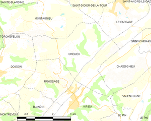
Шельё
- коммуна во Франции
Hiking in Шельё
Chélieu, located in the Isère department of the Auvergne-Rhône-Alpes region in France, offers beautiful landscapes and opportunities for hiking enthusiasts. The area is characterized by its stunning mountainous terrain, with the Chartreuse Mountains nearby providing a range of trails suitable for different skill levels....
- Страна:
- Почтовый код: 38730
- Координаты: 45° 30' 44" N, 5° 28' 33" E
- GPS треки (wikiloc): [Ссылка]
- Высота над уровнем моря: 607 м m
- Площадь: 10.13 кв.км
- Население: 674
- Веб сайт: [Ссылка]