
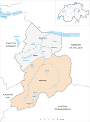
Гларус (Glarus, Kanton Glarus)


- кантон в Швейцарии
 Hiking in Гларус
The Canton of Glarus, located in central Switzerland, is a stunning destination for hikers, offering a variety of trails that cater to different skill levels. Nestled between the rugged Alps and picturesque valleys, the region is known for its breathtaking landscapes, diverse flora and fauna, and charming villages.
Key Hiking Areas and Trails:
-
Glarner Alps: This mountain range offers numerous high-altitude trails, including challenging routes that provide stunning panoramic views. The hike to the Gipfel der Tödi (Piz Russein) is a must for experienced hikers, with exhilarating climbs and rewarding vistas.
-
Klöntalersee: This scenic lake is surrounded by lush forests and mountains, providing a beautiful setting for easy to moderate trails. A popular choice is the loop around the lake, which is about 9 kilometers long and perfect for families.
-
Glarus Valley: The valley features various trails that pass through quaint villages, rich farmland, and impressive mountain scenery. The hike from Glarus to Braunwald is particularly scenic, taking you through idyllic landscapes with excellent opportunities for photography.
-
Elm and Haslital: The area around Elm is known for its stunning geological features, including the impressive Höhenweg which connects various peaks. Enjoy the views over the Haslital Valley and the opportunity to see local wildlife.
-
Hiking with a View: Trails like the Aussichtspunkt Kerenzerberg offer less strenuous options with fantastic views over Lake Zurich and the surrounding mountains, appealing to both families and casual hikers.
Hiking Season:
The hiking season in the Canton of Glarus generally runs from late spring (around May) to early autumn (October). However, trails may vary in accessibility depending on weather conditions, particularly in autumn and winter when snow can linger at higher elevations.
Preparation and Safety:
- Maps and Signs: Trails are usually well-marked with signs and maps available at trailheads. Consider downloading maps onto a GPS-enabled device.
- Equipment: Good hiking boots, weather-appropriate clothing, and trekking poles are recommended. Carry enough water and snacks, especially on longer hikes.
- Weather: The weather can change rapidly in the mountains, so check forecasts before heading out and be prepared for rain or sudden drops in temperature.
Accessibility:
Glarus is accessible by public transportation, with trains and buses connecting major towns and trailheads, making it convenient for day hikes or longer excursions.
With its combination of natural beauty, diverse trails, and rich culture, the Canton of Glarus is an excellent destination for both novice and experienced hikers. Whether you're looking for leisurely walks or challenging climbs, this region has something to offer everyone.
- Страна:

- Столица: Гларус
- Код автомобильного номера: GL
- Координаты: 46° 59' 0" N, 9° 4' 0" E


- GPS треки (wikiloc): [Ссылка]
- Высота над уровнем моря: 472 м m
- Площадь: 685.3 кв.км
- Население: 40000
- Веб сайт: http://www.gl.ch/
- Википедия русская: wiki(ru)
- Википедия английская: wiki(en)
- Википедия национальная: wiki(de)
- Хранилище Wikidata: Wikidata: Q11922
- Галерея изображений в википедии: [Ссылка]
- Катеория в википедии: [Ссылка]
- код Freebase: [/m/01v167]
- код GeoNames: Альт: [2660593]
- код BNF: [15307141x]
- код VIAF: Альт: [169948101]
- ID отношения в OpenStreetMap: [373267]
- код GND: Альт: [4021141-1]
- идентификатор местоположения ArchINFORM: [5883]
- код LCNAF: Альт: [n81129730]
- место в MusicBrainz: [f55f9d22-e955-4cc4-aa5f-cf92cdf2555e]
- код темы Quora: [Canton-of-Glarus]
- код в энциклопедии «Британника онлайн»: [place/Glarus-district-Switzerland]
- код в Encyclopædia Universalis: [glaris]
- идентификатор HDS: [7374]
- код ISNI: Альт: [0000 0004 0627 5734]
- код NKC: [ge961212]
- код NUTS: [CH051]
- идентификатор Ringgold: [60546]
- STW Thesaurus for Economics ID: [16962-4]
- код BAV: [ADV12566057]
- ISO 3166-2: CH-GL
- FIPS 10-4: SZ08
Включает регионы:
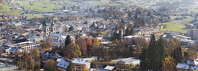

Гларус
Hiking in Гларус
Hiking in Glarus offers a stunning experience with a mix of picturesque landscapes, diverse trails, and a wealth of natural beauty. Located in the heart of Switzerland, Glarus is surrounded by impressive mountains, lush valleys, and clear lakes, making it a perfect destination for outdoor enthusiasts....
- Страна:
- Почтовый код: 8750
- Телефонный код: 055
- Код автомобильного номера: GL
- Координаты: 47° 1' 59" N, 9° 3' 59" E
- GPS треки (wikiloc): [Ссылка]
- Высота над уровнем моря: 474 м m
- Площадь: 103.6 кв.км
- Население: 12515
- Веб сайт: [Ссылка]


Glarus Nord
Hiking in Glarus Nord
Glarus Nord, located in the Swiss canton of Glarus, is a stunning area for hiking, offering a diverse range of trails suitable for various skill levels. The region is characterized by its impressive mountains, lush valleys, and pristine nature, making it ideal for outdoor enthusiasts....
- Страна:
- Почтовый код: 8752, 8753, 8757, 8758, 8865, 8866, 8867, 8868, 8874
- Телефонный код: 055
- Код автомобильного номера: GL
- Координаты: 47° 5' 57" N, 9° 3' 47" E
- GPS треки (wikiloc): [Ссылка]
- Высота над уровнем моря: 437 м m
- Площадь: 147 кв.км
- Население: 18247
- Веб сайт: [Ссылка]

Glarus Süd
Hiking in Glarus Süd
Glarus Süd, located in the canton of Glarus in Switzerland, is a fantastic destination for hiking enthusiasts. This region boasts stunning landscapes, ranging from lush valleys to rugged mountain terrains. Here are some key points about hiking in Glarus Süd:...
- Страна:
- Почтовый код: 8756, 8762, 8765, 8766, 8767, 8772, 8773, 8774, 8775, 8777, 8782, 8783, 8784
- Телефонный код: 055
- Код автомобильного номера: GL
- Координаты: 46° 59' 40" N, 9° 4' 27" E
- GPS треки (wikiloc): [Ссылка]
- Высота над уровнем моря: 521 м m
- Площадь: 430.2 кв.км
- Население: 9581
- Веб сайт: [Ссылка]
Граничит с регионами:
Граубюнден
- кантон в Швейцарии
Hiking in Граубюнден
The Canton of Grisons, or Graubünden, is a breathtaking region in Switzerland known for its stunning landscapes, diverse hiking trails, and rich cultural heritage. Here are some highlights of hiking in this beautiful area:...
- Страна:
- Столица: Кур
- Код автомобильного номера: GR
- Координаты: 46° 45' 0" N, 9° 30' 0" E
- GPS треки (wikiloc): [Ссылка]
- Высота над уровнем моря: 585 м m
- Площадь: 7105.39 кв.км
- Веб сайт: [Ссылка]


Ури
- кантон в Швейцарии
Hiking in Ури
The Canton of Uri, situated in central Switzerland, offers stunning landscapes and a range of hiking opportunities for all skill levels. Here’s a general overview of hiking in this picturesque region:...
- Страна:
- Столица: Альтдорф
- Код автомобильного номера: UR
- Координаты: 46° 47' 0" N, 8° 37' 0" E
- GPS треки (wikiloc): [Ссылка]
- Высота над уровнем моря: 447 м m
- Площадь: 1076.57 кв.км
- Население: 36145
- Веб сайт: [Ссылка]

Швиц
- кантон в Швейцарии
Hiking in Швиц
Hiking in the Canton of Schwyz in Switzerland offers a fantastic blend of stunning landscapes, rich cultural history, and well-maintained trails. The region features a variety of terrains, including mountains, lakes, and picturesque villages, making it a great destination for both novice and experienced hikers....
- Страна:
- Столица: Швиц
- Код автомобильного номера: SZ
- Координаты: 47° 4' 0" N, 8° 45' 0" E
- GPS треки (wikiloc): [Ссылка]
- Высота над уровнем моря: 516 м m
- Площадь: 907.88 кв.км
- Население: 155863
- Веб сайт: [Ссылка]


Санкт-Галлен
- кантон в Швейцарии
Hiking in Санкт-Галлен
The Canton of St. Gallen, located in eastern Switzerland, is a fantastic destination for hiking enthusiasts, boasting a diverse range of trails that cater to various skill levels and interests. Here's an overview of what you can expect:...
- Страна:
- Столица: Санкт-Галлен
- Код автомобильного номера: SG
- Координаты: 47° 20' 0" N, 9° 10' 0" E
- GPS треки (wikiloc): [Ссылка]
- Высота над уровнем моря: 668 м m
- Площадь: 2030.75 кв.км
- Население: 75538
- Веб сайт: [Ссылка]