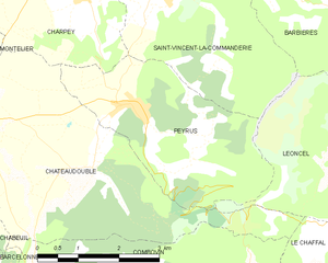
Charpey (Charpey)

- коммуна во Франции
 Hiking in Charpey
Charpey is a small commune in the Drôme department in southeastern France, known for its beautiful natural surroundings and access to hiking trails. While it may not be as widely recognized as some other hiking destinations, it offers a peaceful and picturesque setting for outdoor enthusiasts.
Hiking Trails
-
Regional Natural Park of Vercors: Charpey is located close to the Vercors Mountains, which are part of the Vercors Regional Natural Park. This park offers a variety of hiking trails ranging from easy walks to more challenging alpine routes. You can enjoy stunning views, diverse flora and fauna, and unique geological formations.
-
Local Trails: Explore the smaller trails around Charpey that lead to charming villages, scenic overlooks, and pastoral landscapes. Make sure to check local maps and sources for trail conditions and recommendations.
Considerations
- Season: Spring and autumn are excellent times for hiking in this region due to the mild weather and beautiful foliage. Summer can be warm, so plan for hydration and sun protection.
- Preparation: Always wear appropriate footwear and clothing, bring enough water, snacks, a map, and a first aid kit. It's advised to inform someone about your hiking plans.
- Wildlife: The area is home to diverse wildlife, so keep an eye out for local species and respect their habitats.
Local Tips
- Culture: While hiking, take time to enjoy the local culture and cuisine. You may find cozy inns or restaurants where you can taste regional dishes.
- Guides: Consider hiring a local guide if you're unfamiliar with the area, as they can offer valuable insights and ensure a safer experience.
Hiking in Charpey offers a blend of natural beauty and tranquility, making it a great option for both novice and experienced hikers looking for an off-the-beaten-path experience in France.
- Страна:

- Почтовый код: 26300
- Координаты: 44° 56' 18" N, 5° 5' 34" E


- GPS треки (wikiloc): [Ссылка]
- Площадь: 15.48 кв.км
- Население: 1316
- Википедия английская: wiki(en)
- Википедия национальная: wiki(fr)
- Хранилище Wikidata: Wikidata: Q326106
- Катеория в википедии: [Ссылка]
- код Freebase: [/m/03mhfph]
- код GeoNames: Альт: [6447910]
- номер SIREN: [212600795]
- код BNF: [15252940f]
- код VIAF: Альт: [240047371]
- код муниципалитета INSEE: 26079
Граничит с регионами:

Peyrus
- коммуна во Франции
Hiking in Peyrus
Peyrus is a charming town located in the Auvergne-Rhône-Alpes region of France, near the foothills of the Vercors Massif. It offers a variety of hiking opportunities that cater to different skill levels, showcasing beautiful landscapes, rich biodiversity, and cultural heritage....
- Страна:
- Почтовый код: 26120
- Координаты: 44° 54' 46" N, 5° 6' 30" E
- GPS треки (wikiloc): [Ссылка]
- Площадь: 10.48 кв.км
- Население: 607


Saint-Vincent-la-Commanderie
- коммуна во Франции
Hiking in Saint-Vincent-la-Commanderie
Saint-Vincent-la-Commanderie is a picturesque village located in the Drôme department of southeastern France. It's known for its charming medieval architecture and natural beauty, making it an excellent destination for hiking enthusiasts....
- Страна:
- Почтовый код: 26300
- Координаты: 44° 56' 18" N, 5° 7' 7" E
- GPS треки (wikiloc): [Ссылка]
- Высота над уровнем моря: 390 м m
- Площадь: 13.34 кв.км
- Население: 510
- Веб сайт: [Ссылка]


Bésayes
- коммуна во Франции
Hiking in Bésayes
Bésayes is a small commune in the Drôme department of southeastern France, known for its beautiful landscapes and rural charm. While it may not be a widely recognized hiking destination compared to more famous parks and trails, there are still opportunities for hiking and enjoying the natural beauty of the region....
- Страна:
- Почтовый код: 26300
- Координаты: 44° 57' 54" N, 5° 4' 45" E
- GPS треки (wikiloc): [Ссылка]
- Площадь: 9.53 кв.км
- Население: 1189
- Веб сайт: [Ссылка]


Alixan
- коммуна во Франции
Hiking in Alixan
Alixan is a charming commune located in the Drôme department of southeastern France. While it may not be as well-known as some of the more prominent hiking destinations, it offers a serene landscape and opportunities for outdoor activities, including hiking....
- Страна:
- Почтовый код: 26300
- Координаты: 44° 58' 30" N, 5° 1' 39" E
- GPS треки (wikiloc): [Ссылка]
- Площадь: 28.28 кв.км
- Население: 2484


Châteaudouble
Hiking in Châteaudouble
Châteaudouble, located in the Drôme department of southeastern France, is an excellent destination for hiking enthusiasts. This charming village is nestled amidst stunning natural scenery, characterized by picturesque hills and sweeping valleys....
- Страна:
- Почтовый код: 26120
- Координаты: 44° 53' 59" N, 5° 5' 43" E
- GPS треки (wikiloc): [Ссылка]
- Площадь: 17.37 кв.км
- Население: 583


Montélier
Hiking in Montélier
Montélier, located in the Drôme department of southeastern France, is a charming village that provides access to beautiful hiking opportunities, particularly within the surrounding regions of the Vercors and the Col de la Machine. Here are some highlights for hiking in and around Montélier:...
- Страна:
- Почтовый код: 26120
- Координаты: 44° 56' 15" N, 5° 1' 52" E
- GPS треки (wikiloc): [Ссылка]
- Площадь: 24.76 кв.км
- Население: 4074