Peyrus (Peyrus)

- коммуна во Франции
 Hiking in Peyrus
Peyrus is a charming town located in the Auvergne-Rhône-Alpes region of France, near the foothills of the Vercors Massif. It offers a variety of hiking opportunities that cater to different skill levels, showcasing beautiful landscapes, rich biodiversity, and cultural heritage.
Hiking Trails in and Around Peyrus
-
Vercors Regional Natural Park: Just a short drive from Peyrus, this park offers numerous hiking trails with varying levels of difficulty. The trails take you through stunning limestone cliffs, lush forests, and panoramic views of the surrounding valleys.
-
Les Trois Becs: This is a popular hiking destination that boasts beautiful views and diverse wildlife. The hike to the summit is moderately challenging, but it rewards hikers with breathtaking views of the Drôme Valley and surrounding mountains.
-
Col de la Bataille: A great hike for those looking for a more moderate trail. This route offers a blend of forest paths and open ridges, providing opportunities to see local flora and fauna.
-
Historic Trails: There are paths that lead to historical sites and old villages in the area, giving you a taste of the local heritage and culture while enjoying the beauty of nature.
Tips for Hiking in Peyrus
-
Best Time to Hike: Late spring (May to June) and early autumn (September to October) are ideal for hiking, as the temperatures are mild, and the scenery is vibrant.
-
Gear: Wear sturdy hiking shoes, and dress in layers since weather can change quickly in the mountains. Don't forget to bring a map or a GPS device, enough water, and snacks for your journey.
-
Safety: Always inform someone about your hiking plans and estimated return time, especially if you're venturing into less-traveled trails.
-
Local Regulations: Be aware of and respect local wildlife and natural habitats. Adhere to markers and guidelines, and practice Leave No Trace principles.
Peyrus and its surroundings provide a fantastic opportunity to connect with nature while enjoying the beautiful landscapes and rich cultural offerings of the Rhône-Alpes region. Happy hiking!
- Страна:

- Почтовый код: 26120
- Координаты: 44° 54' 46" N, 5° 6' 30" E


- GPS треки (wikiloc): [Ссылка]
- Площадь: 10.48 кв.км
- Население: 607
- Википедия английская: wiki(en)
- Википедия национальная: wiki(fr)
- Хранилище Wikidata: Wikidata: Q1009368
- Катеория в википедии: [Ссылка]
- код Freebase: [/m/03mgkp8]
- код GeoNames: Альт: [6430165]
- номер SIREN: [212602320]
- код BNF: [15253092f]
- код Pleiades: [167868]
- код муниципалитета INSEE: 26232
Граничит с регионами:


Saint-Vincent-la-Commanderie
- коммуна во Франции
Hiking in Saint-Vincent-la-Commanderie
Saint-Vincent-la-Commanderie is a picturesque village located in the Drôme department of southeastern France. It's known for its charming medieval architecture and natural beauty, making it an excellent destination for hiking enthusiasts....
- Страна:
- Почтовый код: 26300
- Координаты: 44° 56' 18" N, 5° 7' 7" E
- GPS треки (wikiloc): [Ссылка]
- Высота над уровнем моря: 390 м m
- Площадь: 13.34 кв.км
- Население: 510
- Веб сайт: [Ссылка]

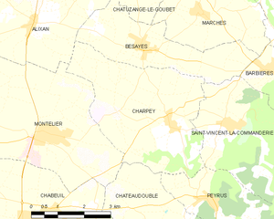
Charpey
- коммуна во Франции
Hiking in Charpey
Charpey is a small commune in the Drôme department in southeastern France, known for its beautiful natural surroundings and access to hiking trails. While it may not be as widely recognized as some other hiking destinations, it offers a peaceful and picturesque setting for outdoor enthusiasts....
- Страна:
- Почтовый код: 26300
- Координаты: 44° 56' 18" N, 5° 5' 34" E
- GPS треки (wikiloc): [Ссылка]
- Площадь: 15.48 кв.км
- Население: 1316
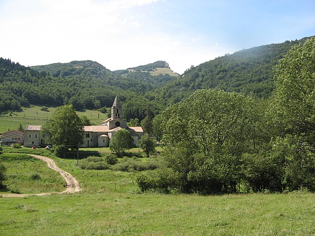

Léoncel
- коммуна во Франции
Hiking in Léoncel
Léoncel is a beautiful village located in the Drôme department of the Auvergne-Rhône-Alpes region in southeastern France. It is situated in the Vercors Massif, which offers diverse landscapes and rich natural beauty, making it an excellent destination for hiking enthusiasts....
- Страна:
- Почтовый код: 26190
- Координаты: 44° 54' 39" N, 5° 11' 34" E
- GPS треки (wikiloc): [Ссылка]
- Площадь: 43.01 кв.км
- Население: 58


Châteaudouble
Hiking in Châteaudouble
Châteaudouble, located in the Drôme department of southeastern France, is an excellent destination for hiking enthusiasts. This charming village is nestled amidst stunning natural scenery, characterized by picturesque hills and sweeping valleys....
- Страна:
- Почтовый код: 26120
- Координаты: 44° 53' 59" N, 5° 5' 43" E
- GPS треки (wikiloc): [Ссылка]
- Площадь: 17.37 кв.км
- Население: 583