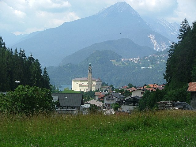
Чимолайс (Cimolais, Cimolais)
.svg)
- коммуна Италии
 Hiking in Чимолайс
Cimolais, located in the beautiful Friuli Venezia Giulia region of Italy, is a stunning destination for hikers. Nestled in the Dolomites, it offers breathtaking landscapes, diverse trails, and a rich natural environment. Here are some highlights about hiking in and around Cimolais:
Trail Options
-
Sentiero del Lupo: This trail takes you through the lush forests and offers viewpoints that showcase the rugged beauty of the Dolomites. It’s moderate in difficulty and ideal for families.
-
Forcella Avanza: A more challenging hike that rewards you with spectacular panoramas. The ascent can be steep in sections, making it suitable for more experienced hikers.
-
Val di Cimoliana: This area boasts several trails that lead through lush valleys, picturesque meadows, and alongside sparkling rivers. The stunning scenery makes it a favorite for both day hikes and longer treks.
Flora and Fauna
The area is home to a wide range of flora and fauna, so keep an eye out for unique plant species and local wildlife, including deer, chamois, and various bird species. The biodiversity makes every hike a new adventure.
Best Time to Hike
The best time for hiking in Cimolais is during the late spring through autumn (May to October). The trails are generally accessible, and the weather is mild. However, be aware that mountain weather can change rapidly, so be prepared for variations.
Tips for Hiking in Cimolais
- Gear Up: Wear sturdy hiking boots, and bring plenty of water, snacks, and sun protection.
- Maps and Guides: Familiarize yourself with the area using maps and local guides. Several organizations offer guided hikes if you prefer to explore with a group.
- Respect Nature: Follow Leave No Trace principles to preserve the beauty of the landscape. Stay on marked paths, and avoid disturbing wildlife.
- Emergency Preparedness: Carry a basic first-aid kit and know the locations of emergency shelters along your route.
Additional Experiences
In addition to hiking, Cimolais offers opportunities for rock climbing, mountain biking, and exploring local culture. After a long hike, you can enjoy local cuisine at nearby restaurants, which often feature delicious regional dishes.
Overall, hiking in Cimolais is an unforgettable experience, providing a perfect blend of stunning scenery, adventure, and a chance to connect with nature.
- Страна:

- Почтовый код: 33080
- Телефонный код: 0427
- Код автомобильного номера: PN
- Координаты: 46° 17' 0" N, 12° 26' 0" E


- GPS треки (wikiloc): [Ссылка]
- Высота над уровнем моря: 652 м m
- Площадь: 100.86 кв.км
- Население: 363
- Веб сайт: http://www.comune.cimolais.pn.it/
- Википедия русская: wiki(ru)
- Википедия английская: wiki(en)
- Википедия национальная: wiki(it)
- Хранилище Wikidata: Wikidata: Q53162
- Катеория в википедии: [Ссылка]
- код Freebase: [/m/0gqz5w]
- код GeoNames: Альт: [6539327]
- код VIAF: Альт: [133842879]
- ID отношения в OpenStreetMap: [79119]
- WOEID: [714103]
- UN/LOCODE: [ITNAM]
- код ISTAT: 093014
- кадастровый код Италии: C699
Граничит с регионами:


Перароло-ди-Кадоре
- коммуна Италии
Hiking in Перароло-ди-Кадоре
Perarolo di Cadore is a charming village located in the Belluno province of the Veneto region in Italy, surrounded by the stunning Dolomite mountains. This area is known for its breathtaking scenery, rich natural heritage, and a variety of hiking trails that cater to different skill levels. Here’s what you should know if you're considering hiking in Perarolo di Cadore:...
- Страна:
- Почтовый код: 32010
- Телефонный код: 0435
- Код автомобильного номера: BL
- Координаты: 46° 23' 44" N, 12° 21' 23" E
- GPS треки (wikiloc): [Ссылка]
- Высота над уровнем моря: 532 м m
- Площадь: 43.94 кв.км
- Население: 372
- Веб сайт: [Ссылка]

Домедже-ди-Кадоре
- коммуна Италии
Hiking in Домедже-ди-Кадоре
Domegge di Cadore is a charming village situated in the Dolomites region of northern Italy. It offers incredible opportunities for hiking, thanks to its stunning natural landscapes, rich biodiversity, and picturesque mountain views. Here are some highlights and information about hiking in the area:...
- Страна:
- Почтовый код: 32040
- Телефонный код: 0435
- Код автомобильного номера: BL
- Координаты: 46° 28' 0" N, 12° 25' 0" E
- GPS треки (wikiloc): [Ссылка]
- Высота над уровнем моря: 775 м m
- Площадь: 50.36 кв.км
- Население: 2392
- Веб сайт: [Ссылка]


Пьеве-ди-Кадоре
- коммуна Италии
Hiking in Пьеве-ди-Кадоре
Pieve di Cadore, located in the Dolomite Mountain range in northern Italy, offers stunning hiking opportunities for both novice and experienced hikers. This scenic town is not just known for its natural beauty but also for its cultural significance, being the birthplace of the famous painter Tiziano Vecellio (Titian)....
- Страна:
- Почтовый код: 32044
- Телефонный код: 0435
- Код автомобильного номера: BL
- Координаты: 46° 26' 0" N, 12° 22' 0" E
- GPS треки (wikiloc): [Ссылка]
- Высота над уровнем моря: 878 м m
- Площадь: 67.17 кв.км
- Население: 3788
- Веб сайт: [Ссылка]


Клаут
- коммуна Италии
Hiking in Клаут
Claut is a picturesque village located in the Friuli Venezia Giulia region of northeastern Italy. Nestled in the heart of the Carnic Alps, it offers excellent hiking opportunities for both beginners and experienced hikers. Here are some aspects to consider when hiking in Claut:...
- Страна:
- Почтовый код: 33080
- Телефонный код: 0427
- Код автомобильного номера: PN
- Координаты: 46° 16' 0" N, 12° 31' 0" E
- GPS треки (wikiloc): [Ссылка]
- Высота над уровнем моря: 613 м m
- Площадь: 165.91 кв.км
- Население: 946
- Веб сайт: [Ссылка]


Эрто-е-Кассо
- коммуна Италии
Hiking in Эрто-е-Кассо
Erto e Casso is a picturesque municipality in the Friuli Venezia Giulia region of Italy, known for its stunning landscapes, rich history, and outdoor activities. It is situated near the Dolomites and the Friulian Alps, making it a great destination for hiking enthusiasts....
- Страна:
- Почтовый код: 33080
- Телефонный код: 0427
- Код автомобильного номера: PN
- Координаты: 46° 16' 35" N, 12° 22' 17" E
- GPS треки (wikiloc): [Ссылка]
- Высота над уровнем моря: 775 м m
- Площадь: 52.43 кв.км
- Население: 371
- Веб сайт: [Ссылка]


Форни-ди-Сопра
- коммуна Италии
Hiking in Форни-ди-Сопра
Forni di Sopra is a beautiful destination for hiking enthusiasts, located in the Friuli Venezia Giulia region of northeastern Italy. Nestled in the Carnic Alps, it offers a stunning backdrop of lush valleys, rugged mountains, and pristine landscapes. Here are some key points about hiking in Forni di Sopra:...
- Страна:
- Почтовый код: 33024
- Телефонный код: 0433
- Код автомобильного номера: UD
- Координаты: 46° 25' 0" N, 12° 35' 0" E
- GPS треки (wikiloc): [Ссылка]
- Высота над уровнем моря: 907 м m
- Площадь: 81.66 кв.км
- Население: 955
- Веб сайт: [Ссылка]