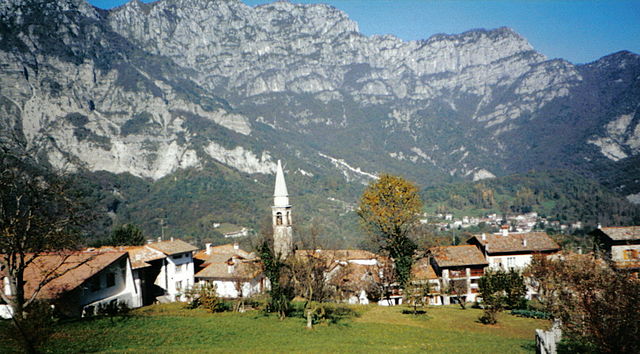
Клаут (Claut, Claut)
.svg)
- коммуна Италии
 Hiking in Клаут
Claut is a picturesque village located in the Friuli Venezia Giulia region of northeastern Italy. Nestled in the heart of the Carnic Alps, it offers excellent hiking opportunities for both beginners and experienced hikers. Here are some aspects to consider when hiking in Claut:
Scenic Trails
- Natural Beauty: The area surrounding Claut features beautiful landscapes, including lush forests, rugged mountains, and serene alpine meadows. You'll often encounter waterfalls, rivers, and stunning vistas as you hike.
- Variety of Trails: There are several marked hiking trails that vary in difficulty, allowing you to choose routes that suit your experience level and fitness.
Popular Hiking Routes
- Sentiero degli Alpini: This trail is a classic, providing breathtaking views of the surrounding mountains and valleys. It's well-marked and a great choice for families.
- Val di Claut: The valley offers various routes that take you deeper into nature, where you can discover local flora and fauna.
- Monte Peralba: For more experienced hikers, this trail leads to one of the prominent peaks in the Carnic Alps, offering a challenging ascent and rewarding panoramic views from the summit.
Flora and Fauna
- Biodiversity: The region is known for its rich biodiversity. As you hike, keep an eye out for unique alpine plants and various wildlife, including deer and birds of prey.
Practical Tips
- Weather: Be prepared for changing weather conditions, especially in higher elevations. It’s wise to check the forecast and dress in layers.
- Hydration and Nutrition: Carry enough water and snacks, especially on longer hikes.
- Local Guidance: Consider hiring a local guide if you're unfamiliar with the area, as they can provide valuable insights and ensure your safety.
- Respect Nature: Follow the Leave No Trace principles to help preserve the natural beauty of the area.
Conclusion
Hiking in Claut can be a rewarding experience, offering a mix of adventure and stunning scenery. Whether you're looking for a leisurely stroll or a challenging trek, you'll find plenty of options to explore the incredible landscapes of the Carnic Alps. Enjoy your hike, and stay safe!
- Страна:

- Почтовый код: 33080
- Телефонный код: 0427
- Код автомобильного номера: PN
- Координаты: 46° 16' 0" N, 12° 31' 0" E


- GPS треки (wikiloc): [Ссылка]
- Высота над уровнем моря: 613 м m
- Площадь: 165.91 кв.км
- Население: 946
- Веб сайт: http://www.comune.claut.pn.it
- Википедия русская: wiki(ru)
- Википедия английская: wiki(en)
- Википедия национальная: wiki(it)
- Хранилище Wikidata: Wikidata: Q53163
- Катеория в википедии: [Ссылка]
- код Freebase: [/m/0gqz6l]
- код GeoNames: Альт: [3178552]
- код BNF: [13556949r]
- код VIAF: Альт: [240526129]
- ID отношения в OpenStreetMap: [79089]
- WOEID: [714210]
- код ISTAT: 093015
- кадастровый код Италии: C790
Граничит с регионами:


Кьес-д'Альпаго
- коммуна Италии
Hiking in Кьес-д'Альпаго
Chies d'Alpago is a beautiful destination for hiking enthusiasts, located in the Veneto region of northern Italy. Nestled in the Alps, this area offers stunning views, diverse landscapes, and a variety of trails suitable for all skill levels....
- Страна:
- Почтовый код: 32010
- Телефонный код: 0437
- Код автомобильного номера: BL
- Координаты: 46° 9' 21" N, 12° 23' 22" E
- GPS треки (wikiloc): [Ссылка]
- Высота над уровнем моря: 647 м m
- Площадь: 44.97 кв.км
- Население: 1328
- Веб сайт: [Ссылка]


Барчис
- коммуна Италии
Hiking in Барчис
Barcis is a picturesque village located in the Friuli Venezia Giulia region of northeastern Italy, surrounded by stunning natural landscapes, including mountains, lakes, and forests. Hiking in Barcis offers a fantastic opportunity to explore the beautiful surroundings and experience the region's rich biodiversity....
- Страна:
- Почтовый код: 33080
- Телефонный код: 0427
- Код автомобильного номера: PN
- Координаты: 46° 11' 0" N, 12° 34' 0" E
- GPS треки (wikiloc): [Ссылка]
- Высота над уровнем моря: 409 м m
- Площадь: 103.41 кв.км
- Население: 256
- Веб сайт: [Ссылка]


Чимолайс
- коммуна Италии
Hiking in Чимолайс
Cimolais, located in the beautiful Friuli Venezia Giulia region of Italy, is a stunning destination for hikers. Nestled in the Dolomites, it offers breathtaking landscapes, diverse trails, and a rich natural environment. Here are some highlights about hiking in and around Cimolais:...
- Страна:
- Почтовый код: 33080
- Телефонный код: 0427
- Код автомобильного номера: PN
- Координаты: 46° 17' 0" N, 12° 26' 0" E
- GPS треки (wikiloc): [Ссылка]
- Высота над уровнем моря: 652 м m
- Площадь: 100.86 кв.км
- Население: 363
- Веб сайт: [Ссылка]


Эрто-е-Кассо
- коммуна Италии
Hiking in Эрто-е-Кассо
Erto e Casso is a picturesque municipality in the Friuli Venezia Giulia region of Italy, known for its stunning landscapes, rich history, and outdoor activities. It is situated near the Dolomites and the Friulian Alps, making it a great destination for hiking enthusiasts....
- Страна:
- Почтовый код: 33080
- Телефонный код: 0427
- Код автомобильного номера: PN
- Координаты: 46° 16' 35" N, 12° 22' 17" E
- GPS треки (wikiloc): [Ссылка]
- Высота над уровнем моря: 775 м m
- Площадь: 52.43 кв.км
- Население: 371
- Веб сайт: [Ссылка]

Фризанко
- коммуна Италии
Hiking in Фризанко
Frisanco, located in the province of Pordenone in the Friuli Venezia Giulia region of Italy, offers a delightful experience for hikers of all levels. The area is surrounded by the beautiful Friulian Dolomites, providing stunning landscapes, varying terrains, and rich natural biodiversity....
- Страна:
- Почтовый код: 33080
- Телефонный код: 0427
- Код автомобильного номера: PN
- Координаты: 46° 13' 0" N, 12° 44' 0" E
- GPS треки (wikiloc): [Ссылка]
- Высота над уровнем моря: 500 м m
- Площадь: 60.99 кв.км
- Население: 600
- Веб сайт: [Ссылка]
Трамонти-ди-Сопра
- коммуна Италии
Hiking in Трамонти-ди-Сопра
Tramonti di Sopra is a beautiful area located in the Friuli Venezia Giulia region of Italy. It's known for its stunning landscapes, lush green valleys, and majestic mountains, making it a great destination for hiking enthusiasts....
- Страна:
- Почтовый код: 33090
- Телефонный код: 0427
- Код автомобильного номера: PN
- Координаты: 46° 19' 0" N, 12° 48' 0" E
- GPS треки (wikiloc): [Ссылка]
- Высота над уровнем моря: 420 м m
- Площадь: 125.15 кв.км
- Население: 301
- Веб сайт: [Ссылка]


Форни-ди-Сопра
- коммуна Италии
Hiking in Форни-ди-Сопра
Forni di Sopra is a beautiful destination for hiking enthusiasts, located in the Friuli Venezia Giulia region of northeastern Italy. Nestled in the Carnic Alps, it offers a stunning backdrop of lush valleys, rugged mountains, and pristine landscapes. Here are some key points about hiking in Forni di Sopra:...
- Страна:
- Почтовый код: 33024
- Телефонный код: 0433
- Код автомобильного номера: UD
- Координаты: 46° 25' 0" N, 12° 35' 0" E
- GPS треки (wikiloc): [Ссылка]
- Высота над уровнем моря: 907 м m
- Площадь: 81.66 кв.км
- Население: 955
- Веб сайт: [Ссылка]


Форни-ди-Сотто
- коммуна Италии
Hiking in Форни-ди-Сотто
Forni di Sotto is a beautiful gem in the Friuli Venezia Giulia region of northern Italy, nestled in the Carnic Alps. This area is known for its stunning natural landscapes, rich biodiversity, and a variety of hiking trails suitable for all levels of experience. Here are some highlights about hiking in Forni di Sotto:...
- Страна:
- Почтовый код: 33020
- Телефонный код: 0433
- Код автомобильного номера: UD
- Координаты: 46° 24' 0" N, 12° 40' 0" E
- GPS треки (wikiloc): [Ссылка]
- Высота над уровнем моря: 777 м m
- Площадь: 93.6 кв.км
- Население: 583
- Веб сайт: [Ссылка]