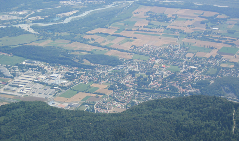
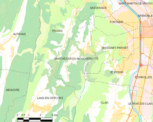
Кле (Claix, Claix)

- коммуна во Франции
 Hiking in Кле
Claix, located in the Isère department of the Auvergne-Rhône-Alpes region of France, offers a variety of beautiful hiking opportunities due to its scenic landscapes and proximity to the French Alps. Here are some highlights and tips for hiking in and around Claix:
Hiking Trails and Areas
-
La Chartreuse Regional Natural Park: This nearby park features numerous trails that range from easy walks to more challenging hikes. You can explore beautiful limestone cliffs, deep gorges, and varied wildlife.
-
The Vercors Massif: Located to the east of Claix, the Vercors offers stunning hikes through panoramic landscapes of mountains and valleys. Popular hikes include the Gorges de la Bourne and the hike to the summit of Le Grand Veymont for breathtaking views.
-
Belledonne Range: To the north of Claix, the Belledonne mountains provide various trails for different skill levels, with opportunities for both day hikes and longer treks. The area is known for its alpine lakes and rugged terrain.
-
Local Trails: Claix itself has several marked trails that are suitable for all skill levels. You might find routes that lead you through fields, forests, and along rivers, showcasing the charm of the region.
Hiking Tips
-
Maps and Guides: Obtain a local hiking map or guidebook to ensure you have detailed information about trail conditions and lengths.
-
Weather Check: Always check the weather forecast before heading out, as conditions can change rapidly in mountain areas.
-
Footwear: Invest in good quality hiking boots, as many of the trails can be rocky or uneven.
-
Hydration and Snacks: Carry enough water and snacks to keep your energy up during your hikes.
-
Wildlife: Respect the local wildlife and maintain a safe distance from animals. Remember to follow Leave No Trace principles to help preserve the natural beauty of the area.
-
Local Regulations: Be aware of any local regulations or restrictions regarding trail usage, especially in protected areas.
Whether you are looking for a leisurely walk or a more strenuous hike, Claix and its surroundings have something to offer for every outdoor enthusiast. Enjoy your hiking adventures!
- Страна:

- Почтовый код: 38640
- Координаты: 45° 7' 11" N, 5° 40' 18" E


- GPS треки (wikiloc): [Ссылка]
- Высота над уровнем моря: 300 м m
- Площадь: 24.12 кв.км
- Население: 8018
- Веб сайт: http://www.ville-claix.fr
- Википедия русская: wiki(ru)
- Википедия английская: wiki(en)
- Википедия национальная: wiki(fr)
- Хранилище Wikidata: Wikidata: Q818965
- Галерея изображений в википедии: [Ссылка]
- Катеория в википедии: [Ссылка]
- код Freebase: [/m/03g_59w]
- код GeoNames: Альт: [6454061]
- номер SIREN: [213801111]
- код BNF: [15257937r]
- код LCNAF: Альт: [no2013000177]
- код муниципалитета INSEE: 38111
Граничит с регионами:

Варс-Альер-э-Риссе
- коммуна во Франции
Hiking in Варс-Альер-э-Риссе
Varces-Allières-et-Risset is a picturesque commune located in the Isère department in southeastern France, near the city of Grenoble. The region is characterized by its stunning natural landscapes, making it an excellent destination for hiking enthusiasts....
- Страна:
- Почтовый код: 38760
- Координаты: 45° 5' 12" N, 5° 40' 55" E
- GPS треки (wikiloc): [Ссылка]
- Площадь: 20.88 кв.км
- Население: 8266
- Веб сайт: [Ссылка]


Сесен
Hiking in Сесен
Seyssins is a picturesque town located near Grenoble in the Auvergne-Rhône-Alpes region of France. It serves as a great base for hiking enthusiasts, offering access to a variety of trails with stunning views of the surrounding mountains and valleys....
- Страна:
- Почтовый код: 38180
- Координаты: 45° 9' 22" N, 5° 40' 47" E
- GPS треки (wikiloc): [Ссылка]
- Площадь: 8 кв.км
- Население: 7213
- Веб сайт: [Ссылка]


Пон-де-Кле
- коммуна во Франции
Hiking in Пон-де-Кле
Le Pont-de-Claix is a charming town located near Grenoble in the Auvergne-Rhône-Alpes region of France. Nestled at the foothills of the French Alps, it offers a variety of hiking opportunities suitable for different skill levels. Here are some highlights and tips for hiking in and around Le Pont-de-Claix:...
- Страна:
- Почтовый код: 38800
- Координаты: 45° 7' 23" N, 5° 41' 53" E
- GPS треки (wikiloc): [Ссылка]
- Площадь: 5.6 кв.км
- Население: 10818
- Веб сайт: [Ссылка]

Сен-Низье-дю-Мушрот
- коммуна во Франции
Hiking in Сен-Низье-дю-Мушрот
Saint-Nizier-du-Moucherotte is a picturesque village located in the French Alps, near Grenoble. It serves as an excellent starting point for various hiking trails that offer stunning views of the surrounding mountains, particularly the iconic Moucherotte peak. Here’s what you need to know about hiking in this area:...
- Страна:
- Почтовый код: 38250
- Координаты: 45° 10' 15" N, 5° 37' 49" E
- GPS треки (wikiloc): [Ссылка]
- Площадь: 11.26 кв.км
- Население: 1112
- Веб сайт: [Ссылка]


Ланс-ан-Веркор
- коммуна во Франции
Hiking in Ланс-ан-Веркор
Lans-en-Vercors is a charming village located in the French Alps, within the Vercors Massif. It is well-known for its stunning natural scenery, offering a range of outdoor activities, particularly hiking. Here are some highlights and tips for hiking in Lans-en-Vercors:...
- Страна:
- Почтовый код: 38250
- Координаты: 45° 7' 41" N, 5° 35' 19" E
- GPS треки (wikiloc): [Ссылка]
- Площадь: 38.67 кв.км
- Население: 2649
- Веб сайт: [Ссылка]