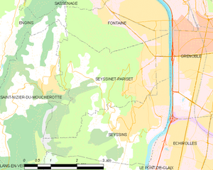
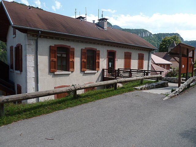
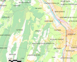
Сен-Низье-дю-Мушрот (Saint-Nizier-du-Moucherotte, Saint-Nizier-du-Moucherotte)

- коммуна во Франции
 Hiking in Сен-Низье-дю-Мушрот
Saint-Nizier-du-Moucherotte is a picturesque village located in the French Alps, near Grenoble. It serves as an excellent starting point for various hiking trails that offer stunning views of the surrounding mountains, particularly the iconic Moucherotte peak. Here’s what you need to know about hiking in this area:
Popular Hiking Trails
-
Moucherotte Summit Trail:
- Distance: Approximately 8 km (5 miles) round trip
- Difficulty: Moderate to challenging
- Elevation Gain: About 800 meters (2,625 feet)
- Highlights: This trail takes you to the summit of Moucherotte, where you can enjoy panoramic views of the surrounding Vercors Massif and the Grenoble valley. The ascent can be steep in sections, so proper footwear and fitness are recommended.
-
Les Crêtes Trail:
- Distance: 14 km (8.7 miles) loop
- Difficulty: Moderate
- Highlights: This loop trail runs along the ridges and provides breathtaking vistas without the rigorous climb of the Moucherotte summit trail. It's ideal for those looking for a scenic, less strenuous hike.
-
Vercors Regional Natural Park:
- The trails in the nearby Vercors Regional Natural Park offer diverse hikes ranging from easy walks to challenging treks. You can explore limestone cliffs, lush forests, and alpine pastures teeming with wildlife.
Essential Tips
- Weather: Check the weather conditions before heading out, as they can change rapidly in the mountains.
- Gear: Wear sturdy hiking boots, bring plenty of water, and pack snacks. A map or GPS device is also advisable.
- Respect Nature: Stick to marked trails to preserve the natural landscape and wildlife.
- Season: Late spring through early fall is ideal for hiking, while winter months can be great for snowshoeing or skiing, depending on the conditions.
Getting There
Saint-Nizier-du-Moucherotte is accessible by car from Grenoble. Public transportation options are limited, so driving or arranging transport is often the best way to reach the area.
Conclusion
Hiking in Saint-Nizier-du-Moucherotte provides an outstanding opportunity to experience the beauty of the French Alps. Whether you are a novice or an experienced hiker, the trails in this area offer a memorable outdoor experience. Always ensure you are prepared and aware of your capabilities on the trails, as safety should be your first priority. Enjoy your hiking adventure!
- Страна:

- Почтовый код: 38250
- Координаты: 45° 10' 15" N, 5° 37' 49" E


- GPS треки (wikiloc): [Ссылка]
- Площадь: 11.26 кв.км
- Население: 1112
- Веб сайт: http://www.saint-nizier-du-moucherotte.fr
- Википедия русская: wiki(ru)
- Википедия английская: wiki(en)
- Википедия национальная: wiki(fr)
- Хранилище Wikidata: Wikidata: Q817606
- Катеория в википедии: [Ссылка]
- код Freebase: [/m/03nvh4v]
- код GeoNames: Альт: [2977860]
- номер SIREN: [213804339]
- код BNF: [15258242n]
- код TGN: [1035472]
- код муниципалитета INSEE: 38433
Граничит с регионами:

Сессине-Паризе
- коммуна во Франции
Hiking in Сессине-Паризе
Seyssinet-Pariset is a lovely commune in the Isère department, located near Grenoble in southeastern France. The region offers a variety of hiking opportunities, with beautiful landscapes that feature both mountainous terrain and lush valleys. Here are some highlights for hiking in Seyssinet-Pariset:...
- Страна:
- Почтовый код: 38170
- Координаты: 45° 10' 53" N, 5° 41' 57" E
- GPS треки (wikiloc): [Ссылка]
- Высота над уровнем моря: 262 м m
- Площадь: 10.65 кв.км
- Население: 12264
- Веб сайт: [Ссылка]
Анжен
- коммуна во Франции
Hiking in Анжен
Hiking in the Écrins National Park, located in the French Alps, offers stunning landscapes, diverse wildlife, and a variety of trails suitable for all levels of hikers. The park features high alpine peaks, glaciers, valleys, and lush meadows, making it a paradise for outdoor enthusiasts....
- Страна:
- Почтовый код: 38360
- Координаты: 45° 10' 52" N, 5° 37' 0" E
- GPS треки (wikiloc): [Ссылка]
- Площадь: 20.64 кв.км
- Население: 473
- Веб сайт: [Ссылка]


Сесен
Hiking in Сесен
Seyssins is a picturesque town located near Grenoble in the Auvergne-Rhône-Alpes region of France. It serves as a great base for hiking enthusiasts, offering access to a variety of trails with stunning views of the surrounding mountains and valleys....
- Страна:
- Почтовый код: 38180
- Координаты: 45° 9' 22" N, 5° 40' 47" E
- GPS треки (wikiloc): [Ссылка]
- Площадь: 8 кв.км
- Население: 7213
- Веб сайт: [Ссылка]


Кле
- коммуна во Франции
Hiking in Кле
Claix, located in the Isère department of the Auvergne-Rhône-Alpes region of France, offers a variety of beautiful hiking opportunities due to its scenic landscapes and proximity to the French Alps. Here are some highlights and tips for hiking in and around Claix:...
- Страна:
- Почтовый код: 38640
- Координаты: 45° 7' 11" N, 5° 40' 18" E
- GPS треки (wikiloc): [Ссылка]
- Высота над уровнем моря: 300 м m
- Площадь: 24.12 кв.км
- Население: 8018
- Веб сайт: [Ссылка]


Ланс-ан-Веркор
- коммуна во Франции
Hiking in Ланс-ан-Веркор
Lans-en-Vercors is a charming village located in the French Alps, within the Vercors Massif. It is well-known for its stunning natural scenery, offering a range of outdoor activities, particularly hiking. Here are some highlights and tips for hiking in Lans-en-Vercors:...
- Страна:
- Почтовый код: 38250
- Координаты: 45° 7' 41" N, 5° 35' 19" E
- GPS треки (wikiloc): [Ссылка]
- Площадь: 38.67 кв.км
- Население: 2649
- Веб сайт: [Ссылка]