Крюзей (Cruseilles, Cruseilles)

- коммуна во Франции
 Hiking in Крюзей
Cruseilles, located in the Auvergne-Rhône-Alpes region of France, offers scenic hiking opportunities with stunning views of the surrounding countryside and the nearby mountains, including the Saleve and the Bornes mountains. Here are some key points about hiking in Cruseilles:
Trails and Routes
- Local Trails: Cruseilles has a range of hiking trails that cater to different skill levels, from easy walks suitable for families to more challenging hikes for experienced hikers.
- GR Trails: The region is part of the Grande Randonnée (GR) network, so you can find long-distance hiking trails that connect to other towns and natural areas.
- Nature Walks: Many trails take you through beautiful forests, vineyards, and fields, allowing hikers to enjoy the flora and fauna unique to the region.
Highlights
- Panoramic Views: Many trails provide breathtaking views of Mont Blanc, Lake Geneva, and the surrounding alpine landscapes.
- Cultural Sites: Some hikes may pass by historical landmarks, churches, and traditional farms, offering insights into the local culture and history.
- Wildlife: The area is home to a variety of wildlife, making it a great spot for nature lovers and birdwatchers.
Tips for Hikers
- Weather: Check the weather conditions before heading out, as they can change quickly in mountainous areas.
- Gear: Wear appropriate hiking shoes and bring adequate gear, including water, snacks, and a map or GPS device for navigation.
- Safety: Always inform someone about your hike's planned route and estimated return time, and consider hiking with a companion, especially on less-traveled paths.
Access
Cruseilles is relatively easy to access from Geneva, making it a great option for a day hike or a weekend getaway. Public transportation or a car can take you to the trailheads.
By exploring the natural beauty and trails of Cruseilles, hikers can enjoy a rewarding experience in the heart of the French Alps. Always remember to respect the environment and follow local guidelines while hiking!
- Страна:

- Почтовый код: 74350
- Координаты: 46° 2' 3" N, 6° 6' 27" E


- GPS треки (wikiloc): [Ссылка]
- Площадь: 25.41 кв.км
- Население: 4326
- Веб сайт: http://www.cruseilles.fr
- Википедия английская: wiki(en)
- Википедия национальная: wiki(fr)
- Хранилище Wikidata: Wikidata: Q762920
- Катеория в википедии: [Ссылка]
- код Freebase: [/m/03ntz1_]
- код GeoNames: Альт: [3022217]
- номер SIREN: [217400969]
- код BNF: [15274354c]
- код VIAF: Альт: [242333484]
- код GND: Альт: [7636845-2]
- код муниципалитета INSEE: 74096
Граничит с регионами:


Villy-le-Pelloux
- коммуна во Франции
Hiking in Villy-le-Pelloux
Villy-le-Pelloux is a charming village located in the Haute-Savoie region of France, near the city of Annecy. The area is known for its breathtaking mountain scenery, lush forests, and a range of outdoor activities, making it a great spot for hiking enthusiasts....
- Страна:
- Почтовый код: 74350
- Координаты: 46° 0' 1" N, 6° 7' 59" E
- GPS треки (wikiloc): [Ссылка]
- Площадь: 2.97 кв.км
- Население: 922
- Веб сайт: [Ссылка]

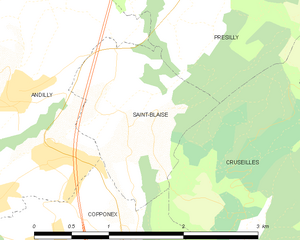
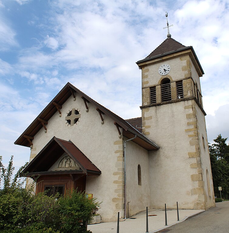
Saint-Blaise, Haute-Savoie
Hiking in Saint-Blaise, Haute-Savoie
Saint-Blaise, located in the Haute-Savoie region of the French Alps, is a beautiful destination for hiking enthusiasts. The area is characterized by stunning alpine scenery, picturesque landscapes, and a variety of trails suited for different skill levels. Here are some highlights about hiking in this region:...
- Страна:
- Почтовый код: 74350
- Координаты: 46° 3' 55" N, 6° 5' 19" E
- GPS треки (wikiloc): [Ссылка]
- Площадь: 2.55 кв.км
- Население: 351
- Веб сайт: [Ссылка]

Cercier
- коммуна во Франции
Hiking in Cercier
Cercier, located in the scenic region of France, offers a variety of hiking opportunities that cater to different skill levels and preferences. The area is known for its beautiful landscapes, which include rolling hills, lush forests, and picturesque valleys. Here are some key points to consider when hiking in Cercier:...
- Страна:
- Почтовый код: 74350
- Координаты: 46° 1' 31" N, 6° 2' 54" E
- GPS треки (wikiloc): [Ссылка]
- Площадь: 11.46 кв.км
- Население: 655
- Веб сайт: [Ссылка]


Copponex
- коммуна во Франции
Hiking in Copponex
Copponex is a small village located in the Haute-Savoie region of France, near the border with Switzerland. The surrounding area offers beautiful landscapes, lush greenery, and an array of hiking opportunities, making it a great destination for outdoor enthusiasts....
- Страна:
- Почтовый код: 74350
- Координаты: 46° 3' 2" N, 6° 4' 25" E
- GPS треки (wikiloc): [Ссылка]
- Площадь: 9.21 кв.км
- Население: 1071
- Веб сайт: [Ссылка]


Groisy
- коммуна во Франции
Hiking in Groisy
Groisy is a charming commune located in the Haute-Savoie department in southeastern France, nestled amidst the picturesque landscapes of the French Alps. The area offers a variety of hiking opportunities, suitable for different skill levels and preferences. Here are some highlights and tips for hiking in Groisy:...
- Страна:
- Почтовый код: 74570
- Координаты: 46° 1' 6" N, 6° 10' 17" E
- GPS треки (wikiloc): [Ссылка]
- Площадь: 21.44 кв.км
- Население: 3498
- Веб сайт: [Ссылка]


Allonzier-la-Caille
- коммуна во Франции
Hiking in Allonzier-la-Caille
Allonzier-la-Caille is a beautiful commune located in the Haute-Savoie department in the Auvergne-Rhône-Alpes region of southeastern France. Nestled amid stunning natural landscapes, it offers various hiking opportunities suitable for different skill levels....
- Страна:
- Почтовый код: 74350
- Координаты: 46° 0' 12" N, 6° 7' 0" E
- GPS треки (wikiloc): [Ссылка]
- Площадь: 9.62 кв.км
- Население: 1944
- Веб сайт: [Ссылка]

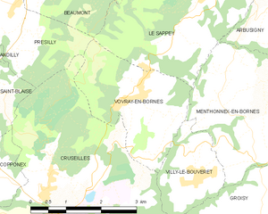
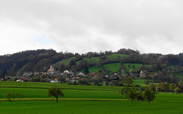
Vovray-en-Bornes
- коммуна во Франции
Hiking in Vovray-en-Bornes
Vovray-en-Bornes is a picturesque village located in the Haute-Savoie region of France, which offers a variety of hiking opportunities for outdoor enthusiasts. The area is characterized by stunning natural beauty, including forests, rolling hills, and views of the nearby mountains....
- Страна:
- Почтовый код: 74350
- Координаты: 46° 3' 56" N, 6° 8' 33" E
- GPS треки (wikiloc): [Ссылка]
- Площадь: 6.57 кв.км
- Население: 441
- Веб сайт: [Ссылка]

Présilly
- коммуна во Франции
Hiking in Présilly
Présilly, located in the Haute-Savoie region of France, offers a variety of hiking opportunities amidst stunning Alpine scenery. This picturesque village is well-positioned near the French-Swiss border, providing access to beautiful trails and natural landscapes....
- Страна:
- Почтовый код: 74160
- Координаты: 46° 5' 35" N, 6° 4' 40" E
- GPS треки (wikiloc): [Ссылка]
- Площадь: 8.66 кв.км
- Население: 774


Villy-le-Bouveret
- коммуна во Франции
Hiking in Villy-le-Bouveret
Villy-le-Bouveret, located in the region of Vaud in Switzerland, offers some beautiful hiking opportunities, especially given its proximity to the stunning landscapes of the Swiss Alps and Lake Geneva. The area is characterized by lush greenery, rolling hills, and scenic views, making it an ideal spot for hiking enthusiasts....
- Страна:
- Почтовый код: 74350
- Координаты: 46° 2' 38" N, 6° 9' 44" E
- GPS треки (wikiloc): [Ссылка]
- Площадь: 3.49 кв.км
- Население: 604
- Веб сайт: [Ссылка]