Сен-Жюльен-ан-Женевуа (arrondissement of Saint-Julien-en-Genevois, arrondissement de Saint-Julien-en-Genevois)

- округ Франции
 Hiking in Сен-Жюльен-ан-Женевуа
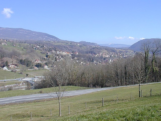
The Arrondissement of Saint-Julien-en-Genevois, located in the Haute-Savoie department in the Auvergne-Rhône-Alpes region of southeastern France, offers a wealth of hiking opportunities amid stunning Alpine scenery. Here are some key aspects to consider when exploring this area:
Scenic Trails
-
Mont Salève: Just across the border from Geneva, Mont Salève offers various trails suitable for all skill levels. The panoramic views of the Geneva area and the surrounding Alps make it a popular spot. You can hike to the summit or enjoy a leisurely stroll along the trails.
-
Le Plateau de Glières: This plateau is a historical site and offers a range of hiking paths. The landscape features rolling hills, wildflower meadows, and breathtaking views. It's also a great location for learning about local history.
-
Nature Reserves: The nearby nature reserves, such as the Réserve Naturelle de la Haute-Chaîne du Jura, offer peaceful walking paths where you can spot local wildlife and enjoy diverse flora.
Trail Difficulty
- Easy: Many trails near Saint-Julien-en-Genevois are suitable for families and beginners, often marked with clear signage.
- Moderate to Challenging: As you venture into higher altitudes or more isolated areas, expect steeper climbs and rugged terrain. Some trails may require proper hiking gear.
Best Times to Hike
- Spring (April to June): Wildflowers are in bloom, and temperatures are mild.
- Summer (July to August): This season offers the best weather for hiking, but popular trails can be crowded.
- Autumn (September to October): The changing foliage presents beautiful landscapes, and cooler temperatures make for enjoyable hiking.
Essential Tips
- Gear: Wear appropriate footwear and pack layers, as weather can change rapidly in the mountains.
- Hydration and Snacks: Always carry enough water and energy snacks, especially on longer hikes.
- Navigation: While many trails are well-marked, consider carrying a map or GPS device if you venture into less familiar areas.
- Wildlife Awareness: Be mindful of local wildlife and follow guidelines to ensure both your safety and the protection of animals and their habitats.
Local Amenities
Saint-Julien-en-Genevois offers various amenities, including restaurants and shops, where you can fuel up before or after your hikes. Additionally, tourist information centers can provide updated trail maps and advice.
Overall, hiking in the Arrondissement of Saint-Julien-en-Genevois allows you to experience the beauty of the Alps while enjoying the serenity of nature. Whether you're a seasoned hiker or looking for a family-friendly outing, there's something for everyone in this picturesque region.
- Страна:

- Столица: Сен-Жюльен-ан-Женевуа
- Координаты: 46° 5' 0" N, 6° 5' 0" E


- GPS треки (wikiloc): [Ссылка]
- Площадь: 659 кв.км
- Население: 184503
- Википедия русская: wiki(ru)
- Википедия английская: wiki(en)
- Википедия национальная: wiki(fr)
- Хранилище Wikidata: Wikidata: Q702367
- Катеория в википедии: [Ссылка]
- код Freebase: [/m/095hs1]
- код GeoNames: Альт: [2979071]
- код округа INSEE: [743]
- код GNS: -1466392
Включает регионы:

Аннмасс-Север
- кантон Франции
Hiking in Аннмасс-Север
Canton d'Annemasse-Nord, located in the Haute-Savoie region of France, is a fantastic area for hiking enthusiasts. The region's diverse landscapes range from gentle valleys to more rugged mountain terrain, making it ideal for hikers of all skill levels. Here are some highlights and tips for hiking in this area:...

Canton of Reignier-Ésery
Hiking in Canton of Reignier-Ésery
Canton de Reignier-Ésery, located in the Haute-Savoie region of France, is a beautiful area that offers a range of hiking opportunities for both novice and experienced hikers. Nestled between the majestic Alps and the lush valleys, here are some highlights and tips for hiking in this region:...
- Страна:
- Столица: Reignier-Esery
- Координаты: 46° 7' 51" N, 6° 16' 20" E
- GPS треки (wikiloc): [Ссылка]
Аннмасс-Юг
- кантон Франции
Hiking in Аннмасс-Юг
Canton d'Annemasse-Sud, situated in the Haute-Savoie region of France, is a wonderful destination for hiking enthusiasts. This area offers a mixture of stunning landscapes, including rolling hills, lush forests, and panoramic views of the surrounding Alps. Here are some key points to consider when hiking in this region:...
Canton of Frangy
Hiking in Canton of Frangy
Canton de Frangy is located in the Haute-Savoie region of southeastern France, nestled in the picturesque landscapes of the Alps. This area offers a variety of hiking opportunities suited for different skill levels, with trails that boast stunning views of the surrounding mountains, valleys, and sometimes even the nearby Lake Geneva....
Сен-Жюльен-ан-Женевуа
- кантон Франции
Hiking in Сен-Жюльен-ан-Женевуа
The Canton of Saint-Julien-en-Genevois, located in the Haute-Savoie region of France near the border with Switzerland, offers a variety of hiking opportunities that cater to different skill levels. The region is characterized by its beautiful landscapes, including rolling hills, lush forests, and stunning views of the Alps and Mont Blanc....
- Страна:
- Столица: Сен-Жюльен-ан-Женевуа
- Координаты: 46° 6' 34" N, 6° 2' 22" E
- GPS треки (wikiloc): [Ссылка]
- Население: 59896

canton of Seyssel
Hiking in canton of Seyssel
Canton de Seyssel, situated in the Haute-Savoie department of France, offers a beautiful backdrop for hiking enthusiasts, combining stunning landscapes with a variety of trails suitable for different skill levels. Here are some highlights and considerations for hiking in this region:...

Крюзей
- кантон во Франции
Hiking in Крюзей
Canton de Cruseilles, located in the Haute-Savoie region of France, is known for its beautiful landscapes, rolling hills, and scenic views of the surrounding Alps. Hiking in this area offers an excellent blend of nature, history, and stunning panoramas. Here are some key points for hiking in Canton de Cruseilles:...
- Страна:
- Столица: Крюзей
- Координаты: 46° 3' 3" N, 6° 6' 33" E
- GPS треки (wikiloc): [Ссылка]
- Площадь: 109.2 кв.км