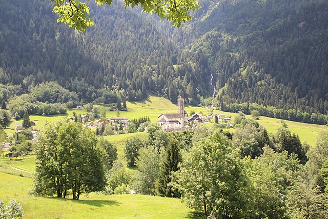
Dalpe (Dalpe)

 Hiking in Dalpe
Dalpe is a charming village located in the Ticino region of Switzerland, nestled in the beautiful Lepontine Alps. It offers a rich variety of hiking opportunities that cater to both novice and experienced hikers. Here are some highlights:
Trails and Routes
-
Dalpe to Blenio Valley: This hike provides stunning views of the valley and surrounding peaks. The route often takes you through picturesque villages, meadows, and forests.
-
Alpe di Campra: Starting from Dalpe, this trail leads up to Alpe di Campra, known for its scenic landscapes and wildlife. The hike is moderately challenging, but the panoramic views from the top are rewarding.
-
Pizzo Ruscada: For those seeking a more demanding hike, the trail to Pizzo Ruscada offers a steep ascent but promises breathtaking vistas.
-
Nature Trails: There are also well-marked nature trails around Dalpe, suitable for families or casual hikers. These trails often have educational signs about local flora and fauna.
Best Time to Hike
The best time to hike in Dalpe is late spring through early autumn (May to October) when the weather is generally mild and the trails are accessible. Be mindful of weather changes, especially in the mountains, where conditions can change rapidly.
Preparing for Your Hike
- Gear: Wear suitable hiking boots, dress in layers, and carry a rain jacket. A good backpack with water and snacks is essential.
- Navigation: Most trails are marked, but it’s advisable to carry a map or GPS device.
- Safety: Always let someone know your hiking plans, stay on marked trails, and be aware of your physical limits.
Local Attractions
After hiking, Dalpe and the surrounding areas offer several attractions, including traditional Ticinese cuisine in local restaurants and opportunities to relax by lakes or explore nearby towns.
Whether you're looking for a leisurely walk or an exhilarating trek, Dalpe provides the perfect setting for hikers to enjoy the stunning Swiss landscape!
- Страна:

- Почтовый код: 6774
- Телефонный код: 091
- Код автомобильного номера: TI
- Координаты: 46° 28' 0" N, 8° 46' 0" E


- GPS треки (wikiloc): [Ссылка]
- Высота над уровнем моря: 1192 м m
- Площадь: 14.5 кв.км
- Население: 186
- Веб сайт: http://www.dalpe.ch
- Википедия английская: wiki(en)
- Википедия национальная: wiki(de)
- Хранилище Wikidata: Wikidata: Q67756
- Катеория в википедии: [Ссылка]
- код Freebase: [/m/0gxlml]
- код GeoNames: Альт: [2661052]
- код VIAF: Альт: [132736071]
- ID отношения в OpenStreetMap: [1684674]
- код GND: Альт: [4749403-7]
- код LCNAF: Альт: [n2005054679]
- идентификатор HDS: [2075]
- код швейцарского муниципалитета: [5071]
Граничит с регионами:

Prato
Hiking in Prato
Prato is a picturesque village situated in the Leventina valley in the Canton of Ticino, Switzerland. It offers stunning landscapes, rich history, and a variety of hiking trails that cater to different skill levels. Here are some highlights for hiking in Prato and its surroundings:...
- Страна:
- Почтовый код: 6773
- Телефонный код: 091
- Код автомобильного номера: TI
- Координаты: 46° 29' 0" N, 8° 45' 0" E
- GPS треки (wikiloc): [Ссылка]
- Высота над уровнем моря: 1045 м m
- Площадь: 16.9 кв.км
- Население: 413
- Веб сайт: [Ссылка]


Lavizzara
Hiking in Lavizzara
Lavizzara is a beautiful region located in the southern part of Switzerland, specifically in the Ticino canton. It is well-known for its stunning landscapes, rich natural beauty, and picturesque mountain views, making it an excellent destination for hiking enthusiasts....
- Страна:
- Почтовый код: 6695
- Телефонный код: 091
- Код автомобильного номера: TI
- Координаты: 46° 26' 0" N, 8° 39' 0" E
- GPS треки (wikiloc): [Ссылка]
- Высота над уровнем моря: 702 м m
- Площадь: 187.21 кв.км
- Население: 526
- Веб сайт: [Ссылка]


Faido
Hiking in Faido
Faido, located in the Leventina Valley of Switzerland, is a beautiful destination for hikers, offering stunning alpine landscapes, diverse trails, and a range of experiences for different skill levels. Here are some key points to consider for hiking in Faido:...
- Страна:
- Почтовый код: 6760
- Телефонный код: 091
- Код автомобильного номера: TI
- Координаты: 46° 29' 0" N, 8° 48' 0" E
- GPS треки (wikiloc): [Ссылка]
- Высота над уровнем моря: 1352 м m
- Площадь: 25.5 кв.км
- Население: 2949
- Веб сайт: [Ссылка]