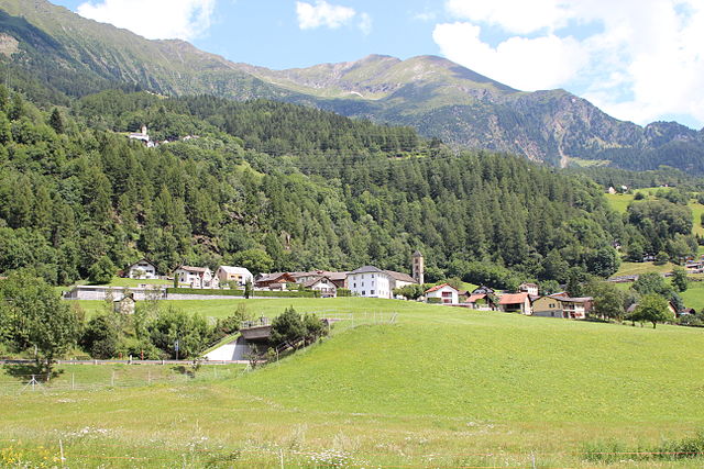
Prato (Prato)
%202012.png)
 Hiking in Prato
Prato is a picturesque village situated in the Leventina valley in the Canton of Ticino, Switzerland. It offers stunning landscapes, rich history, and a variety of hiking trails that cater to different skill levels. Here are some highlights for hiking in Prato and its surroundings:
Hiking Trails
-
Prato Leventina to Crenna: This moderate trail takes you through beautiful forests and meadows, offering splendid views of the surrounding mountains and valleys. It generally takes about 2-3 hours to complete.
-
The Via Alta della Leventina: A more challenging hike, this via takes you along the ridge above the Leventina valley. It's a multi-day trek that connects with various huts and offers breathtaking vistas. Ensure you're prepared with proper gear and maps.
-
Prato to the San Giovanni Church: A fairly easy and short hike that allows you to explore local culture and history. The church’s architecture is lovely, and the path is not overly demanding, suitable for families.
-
Hiking to Lake Ritom: A bit further, but definitely worth it. Starting from Prato, you can hike towards Lake Ritom, which is surrounded by mountains and ideal for picnicking or a refreshing break.
Best Time to Hike
The best times for hiking in the area are from late spring to early autumn (May to October). Summer months are particularly beautiful, with wildflowers blooming and clear skies, while early autumn provides stunning fall foliage.
Tips for Hiking in Prato
- Preparation: Always check the weather forecast and trail conditions before heading out. It’s also wise to bring a detailed map or use a GPS.
- Gear: Wear sturdy hiking boots and dress in layers to adjust to changing weather conditions. Carry enough water and snacks, as some trails may not have facilities.
- Respect Nature: Follow the Leave No Trace principles to preserve the natural beauty of the area.
- Local Guidance: If you’re unfamiliar with the area, consider joining a guided hiking tour to enhance your experience and ensure safety.
Local Attractions
After a day of hiking, you can explore local attractions such as traditional Ticinese cuisine at local restaurants, visit nearby historical sites, or relax in one of the charming local accommodations.
Hiking in Prato offers an amazing opportunity to connect with nature and enjoy the stunning vistas of the Swiss Alps. Happy hiking!
- Страна:

- Почтовый код: 6773
- Телефонный код: 091
- Код автомобильного номера: TI
- Координаты: 46° 29' 0" N, 8° 45' 0" E


- GPS треки (wikiloc): [Ссылка]
- Высота над уровнем моря: 1045 м m
- Площадь: 16.9 кв.км
- Население: 413
- Веб сайт: http://pratoleventina.ch
- Википедия английская: wiki(en)
- Википедия национальная: wiki(de)
- Хранилище Wikidata: Wikidata: Q67677
- Катеория в википедии: [Ссылка]
- код Freebase: [/m/0gxlyz]
- код GeoNames: Альт: [2659148]
- код VIAF: Альт: [239669047]
- ID отношения в OpenStreetMap: [1684742]
- код GND: Альт: [4812922-7]
- идентификатор HDS: [2082]
- код швейцарского муниципалитета: [5078]
Граничит с регионами:

Quinto
Hiking in Quinto
Quinto is a picturesque village located in the southern part of Switzerland, specifically in the Ticino canton. This area is renowned for its stunning landscapes, rich natural diversity, and variety of hiking trails. Here are some highlights for hiking in and around Quinto:...
- Страна:
- Почтовый код: 6777
- Телефонный код: 091
- Код автомобильного номера: TI
- Координаты: 46° 31' 0" N, 8° 42' 0" E
- GPS треки (wikiloc): [Ссылка]
- Высота над уровнем моря: 1915 м m
- Площадь: 75.2 кв.км
- Население: 1044
- Веб сайт: [Ссылка]


Dalpe
Hiking in Dalpe
Dalpe is a charming village located in the Ticino region of Switzerland, nestled in the beautiful Lepontine Alps. It offers a rich variety of hiking opportunities that cater to both novice and experienced hikers. Here are some highlights:...
- Страна:
- Почтовый код: 6774
- Телефонный код: 091
- Код автомобильного номера: TI
- Координаты: 46° 28' 0" N, 8° 46' 0" E
- GPS треки (wikiloc): [Ссылка]
- Высота над уровнем моря: 1192 м m
- Площадь: 14.5 кв.км
- Население: 186
- Веб сайт: [Ссылка]


Lavizzara
Hiking in Lavizzara
Lavizzara is a beautiful region located in the southern part of Switzerland, specifically in the Ticino canton. It is well-known for its stunning landscapes, rich natural beauty, and picturesque mountain views, making it an excellent destination for hiking enthusiasts....
- Страна:
- Почтовый код: 6695
- Телефонный код: 091
- Код автомобильного номера: TI
- Координаты: 46° 26' 0" N, 8° 39' 0" E
- GPS треки (wikiloc): [Ссылка]
- Высота над уровнем моря: 702 м m
- Площадь: 187.21 кв.км
- Население: 526
- Веб сайт: [Ссылка]

Faido
Hiking in Faido
Faido, located in the Leventina Valley of Switzerland, is a beautiful destination for hikers, offering stunning alpine landscapes, diverse trails, and a range of experiences for different skill levels. Here are some key points to consider for hiking in Faido:...
- Страна:
- Почтовый код: 6760
- Телефонный код: 091
- Код автомобильного номера: TI
- Координаты: 46° 29' 0" N, 8° 48' 0" E
- GPS треки (wikiloc): [Ссылка]
- Высота над уровнем моря: 1352 м m
- Площадь: 25.5 кв.км
- Население: 2949
- Веб сайт: [Ссылка]