Lavizzara (Lavizzara)

 Hiking in Lavizzara
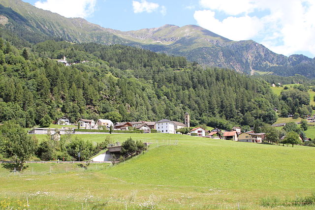
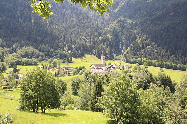
Lavizzara is a beautiful region located in the southern part of Switzerland, specifically in the Ticino canton. It is well-known for its stunning landscapes, rich natural beauty, and picturesque mountain views, making it an excellent destination for hiking enthusiasts.
Key Highlights of Hiking in Lavizzara:
-
Scenic Trails: The Lavizzara Valley features a variety of hiking trails that cater to all levels of experience, from easy walks to more challenging routes. The trails often offer stunning views of the surrounding mountains, lush valleys, and pristine forests.
-
Nature and Wildlife: Hikers can enjoy the diverse flora and fauna of the region, including unique alpine plants and wildlife such as ibex, chamois, and various bird species. The natural beauty is particularly accentuated in spring and summer when wildflowers are in bloom.
-
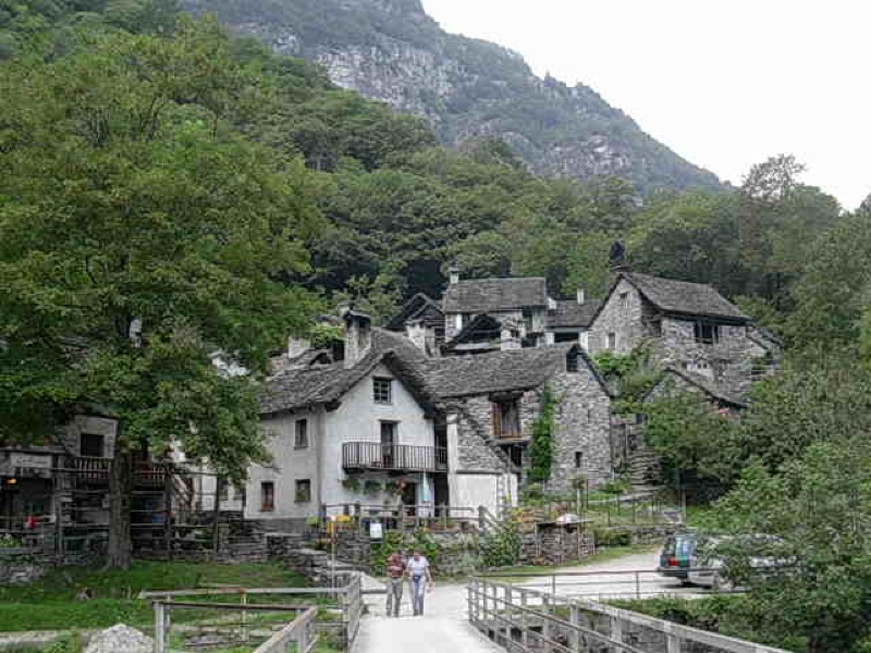
Historical Significance: The area is home to traditional Ticinese villages, where hikers can explore Swiss culture and history. Some trails connect to historical sites and charming hamlets, providing insights into the local way of life.
-
Accessible Peaks: Lavizzara is surrounded by impressive peaks including the peaks of the Swiss Alps. Peak ascents like Pizzo di Campello and Pizzo Forno offer rewarding views for those looking to summit higher altitudes.
-
Hiking Seasons: The best times for hiking in Lavizzara are generally late spring through early autumn. Summer months provide the best conditions, but be sure to check trail conditions in early spring or after heavy rainfall or snow melts.
-
Safety and Preparation: Always check the weather forecast before heading out, wear appropriate footwear, and carry enough water and snacks. Consider having a map or a navigation app as some trails can be less marked in remote areas.
-
Local Resources: The region has several visitor centers and local guides who can provide maps, guided tours, and additional information about the trails.
-
Getting There: Lavizzara is accessible by public transport or car. The closest larger town is Locarno, which has bus connections to various parts of the Lavizzara Valley.
Whether you're looking for a leisurely stroll or a multi-day hike through the mountains, Lavizzara offers an array of options that showcase the stunning natural landscapes of the Swiss Alps. Enjoy your hiking adventure!
- Страна:

- Почтовый код: 6695
- Телефонный код: 091
- Код автомобильного номера: TI
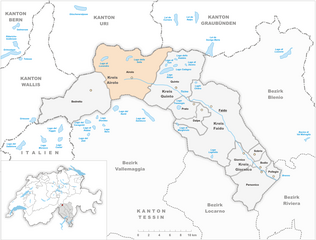
- Координаты: 46° 26' 0" N, 8° 39' 0" E


- GPS треки (wikiloc): [Ссылка]
- Высота над уровнем моря: 702 м m
- Площадь: 187.21 кв.км
- Население: 526
- Веб сайт: http://www.lavizzara.ch
- Википедия английская: wiki(en)
- Википедия национальная: wiki(de)
- Хранилище Wikidata: Wikidata: Q68005
- Галерея изображений в википедии: [Ссылка]
- Катеория в википедии: [Ссылка]
- код Freebase: [/m/0gxmr_]
- код GeoNames: Альт: [7286292]
- код VIAF: Альт: [223790264]
- ID отношения в OpenStreetMap: [1684694]
- код GND: Альт: [7578969-3]
- идентификатор местоположения ArchINFORM: [42788]
- идентификатор HDS: [49005]
- код швейцарского муниципалитета: [5323]
Граничит с регионами:


Bedretto
Hiking in Bedretto
Bedretto, a picturesque valley located in the Swiss Alps, is a fantastic destination for hiking enthusiasts. Nestled between the mountain chains of the Lepontine Alps, it offers breathtaking landscapes, lush meadows, and a range of trails suitable for various skill levels....
- Страна:
- Почтовый код: 6781
- Телефонный код: 091
- Код автомобильного номера: TI
- Координаты: 46° 30' 0" N, 8° 31' 0" E
- GPS треки (wikiloc): [Ссылка]
- Высота над уровнем моря: 1402 м m
- Площадь: 75.2 кв.км
- Население: 109
- Веб сайт: [Ссылка]

Quinto
Hiking in Quinto
Quinto is a picturesque village located in the southern part of Switzerland, specifically in the Ticino canton. This area is renowned for its stunning landscapes, rich natural diversity, and variety of hiking trails. Here are some highlights for hiking in and around Quinto:...
- Страна:
- Почтовый код: 6777
- Телефонный код: 091
- Код автомобильного номера: TI
- Координаты: 46° 31' 0" N, 8° 42' 0" E
- GPS треки (wikiloc): [Ссылка]
- Высота над уровнем моря: 1915 м m
- Площадь: 75.2 кв.км
- Население: 1044
- Веб сайт: [Ссылка]


Севио
Hiking in Севио
Cevio is a charming village located in the Maggia Valley in the Canton of Ticino, Switzerland. It's known for its picturesque landscapes, rich history, and the surrounding natural beauty, making it an excellent destination for hiking enthusiasts....
- Страна:
- Почтовый код: 6675
- Телефонный код: 091
- Код автомобильного номера: TI
- Координаты: 46° 22' 42" N, 8° 32' 32" E
- GPS треки (wikiloc): [Ссылка]
- Высота над уровнем моря: 788 м m
- Площадь: 151.27 кв.км
- Население: 1177
- Веб сайт: [Ссылка]

Prato
Hiking in Prato
Prato is a picturesque village situated in the Leventina valley in the Canton of Ticino, Switzerland. It offers stunning landscapes, rich history, and a variety of hiking trails that cater to different skill levels. Here are some highlights for hiking in Prato and its surroundings:...
- Страна:
- Почтовый код: 6773
- Телефонный код: 091
- Код автомобильного номера: TI
- Координаты: 46° 29' 0" N, 8° 45' 0" E
- GPS треки (wikiloc): [Ссылка]
- Высота над уровнем моря: 1045 м m
- Площадь: 16.9 кв.км
- Население: 413
- Веб сайт: [Ссылка]


Dalpe
Hiking in Dalpe
Dalpe is a charming village located in the Ticino region of Switzerland, nestled in the beautiful Lepontine Alps. It offers a rich variety of hiking opportunities that cater to both novice and experienced hikers. Here are some highlights:...
- Страна:
- Почтовый код: 6774
- Телефонный код: 091
- Код автомобильного номера: TI
- Координаты: 46° 28' 0" N, 8° 46' 0" E
- GPS треки (wikiloc): [Ссылка]
- Высота над уровнем моря: 1192 м m
- Площадь: 14.5 кв.км
- Население: 186
- Веб сайт: [Ссылка]

Maggia
Hiking in Maggia
Maggia, a picturesque municipality located in the Ticino region of Switzerland, is renowned for its stunning natural landscapes and diverse hiking opportunities. Situated in the Maggia Valley, this area features beautiful scenery with lush forests, dramatic mountain vistas, and the refreshing waters of the Maggia River....
- Страна:
- Почтовый код: 6673
- Телефонный код: 091
- Код автомобильного номера: TI
- Координаты: 46° 16' 9" N, 8° 40' 51" E
- GPS треки (wikiloc): [Ссылка]
- Высота над уровнем моря: 342 м m
- Площадь: 111.07 кв.км
- Население: 2586
- Веб сайт: [Ссылка]

Brione (Verzasca)
Hiking in Brione (Verzasca)
Hiking in Brione, located in the Verzasca Valley of Switzerland, offers a stunning experience featuring picturesque landscapes, dramatic cliffs, and the beautiful Verzasca River. Here’s what you can expect and some tips for your hiking adventure:...
- Страна:
- Почтовый код: 6634
- Телефонный код: 091
- Код автомобильного номера: TI
- Координаты: 46° 17' 45" N, 8° 47' 27" E
- GPS треки (wikiloc): [Ссылка]
- Высота над уровнем моря: 750 м m
- Площадь: 48.5 кв.км
- Население: 190
- Веб сайт: [Ссылка]

Airolo
Hiking in Airolo
Airolo, located in the Ticino canton of Switzerland, is an excellent destination for hiking enthusiasts. It sits at the foot of the Gotthard Pass and offers a variety of trails that cater to different skill levels, from leisurely walks to more challenging treks....
- Страна:
- Почтовый код: 6781; 6780
- Телефонный код: 091
- Код автомобильного номера: TI
- Координаты: 46° 32' 0" N, 8° 37' 0" E
- GPS треки (wikiloc): [Ссылка]
- Высота над уровнем моря: 2132 м m
- Площадь: 94.5 кв.км
- Население: 1527
- Веб сайт: [Ссылка]

Faido
Hiking in Faido
Faido, located in the Leventina Valley of Switzerland, is a beautiful destination for hikers, offering stunning alpine landscapes, diverse trails, and a range of experiences for different skill levels. Here are some key points to consider for hiking in Faido:...
- Страна:
- Почтовый код: 6760
- Телефонный код: 091
- Код автомобильного номера: TI
- Координаты: 46° 29' 0" N, 8° 48' 0" E
- GPS треки (wikiloc): [Ссылка]
- Высота над уровнем моря: 1352 м m
- Площадь: 25.5 кв.км
- Население: 2949
- Веб сайт: [Ссылка]


Sonogno
Hiking in Sonogno
Sonogno is a picturesque village located in the Verzasca Valley, in the canton of Ticino, Switzerland. It’s known for its stunning landscapes, traditional stone houses, and its tranquil setting, making it a great destination for hiking enthusiasts....
- Страна:
- Почтовый код: 6637
- Телефонный код: 091
- Код автомобильного номера: TI
- Координаты: 46° 21' 0" N, 8° 47' 0" E
- GPS треки (wikiloc): [Ссылка]
- Высота над уровнем моря: 919 м m
- Площадь: 37.6 кв.км
- Население: 88
- Веб сайт: [Ссылка]