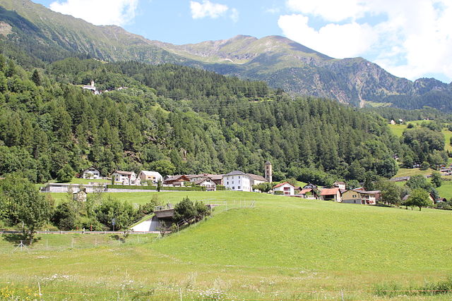
Левентина (Leventina District, Bezirk Leventina)

 Hiking in Левентина
Leventina District, located in the Swiss canton of Ticino, is a fantastic destination for hiking enthusiasts. This valley is known for its stunning landscapes, charming villages, and rich cultural heritage. Here are some key features and highlights of hiking in the Leventina District:
Scenic Trails
-
Valle Leventina: The valley itself offers numerous trails that cater to different skill levels, from easy walks to challenging hikes. The panoramic views of the surrounding mountains enhance the hiking experience.
-
Oberalp Pass: This area offers breathtaking trails leading to the peaks around the pass. The combination of alpine scenery and diverse flora makes it an attractive spot for hikers.
-
Greina Plateau: Located near the Leventina, the Greina Plateau is known for its unique landscapes, including wide alpine meadows and impressive rock formations. The panoramic views from here are truly spectacular.
-
Riviera di Leventina: The region also has beautiful, less strenuous paths that follow the Ticino River, ideal for leisurely hikes with opportunities to enjoy picnics and observe local wildlife.
Accessibility
- The hiking trails in the Leventina District are well-marked and maintained, making them accessible for all levels of hikers. Additionally, public transportation options link the villages and starting points of many trails.
Cultural Experience
- As you hike, you can explore several picturesque villages such as Airolo and Biasca. These towns feature traditional Ticino architecture, local cuisine, and cultural landmarks.
Seasonal Considerations
- Summer Hiking: Summer is ideal for accessing most trails. The weather is typically warm, and the landscapes are lush and vibrant.
- Winter Hiking: Some trails remain accessible in winter for snowshoe hiking and winter walking, offering a completely different experience with snow-capped landscapes.
Safety Tips
- Always check the weather forecast before heading out, and be prepared for rapid changes in weather, especially in mountainous areas.
- Ensure you have appropriate gear, including sturdy hiking boots, adequate clothing, and plenty of water and snacks.
- It’s recommended to travel with a map or GPS device, especially on less familiar trails.
Conclusion
Hiking in the Leventina District offers a wonderful blend of natural beauty, cultural richness, and varied landscapes. Whether you're a casual walker or an experienced hiker, this region provides ample opportunities to connect with nature and enjoy outdoor adventure.
- Страна:

- Код автомобильного номера: TI
- Координаты: 46° 29' 0" N, 8° 48' 0" E


- GPS треки (wikiloc): [Ссылка]
- Высота над уровнем моря: 1753 м m
- Площадь: 479.7 кв.км
- Википедия русская: wiki(ru)
- Википедия английская: wiki(en)
- Википедия национальная: wiki(de)
- Хранилище Wikidata: Wikidata: Q539271
- Катеория в википедии: [Ссылка]
- код Freebase: [/m/0grwyv]
- код GeoNames: Альт: [6458903]
- идентификатор местоположения ArchINFORM: [42224]
- идентификатор HDS: [8543]
Включает регионы:

Faido Subdistrict
Hiking in Faido Subdistrict
Kreis Faido, located in the Canton of Ticino in Switzerland, offers a beautiful hiking experience characterized by stunning landscapes, diverse trails, and a rich natural environment. Here are some highlights and tips for hiking in this area:...
- Страна:


Kreis Giornico
Hiking in Kreis Giornico
Kreis Giornico, located in the picturesque region of Ticino in Switzerland, offers stunning landscapes and a variety of hiking opportunities. The area is characterized by its beautiful valleys, mountains, and charming villages, making it a wonderful destination for outdoor enthusiasts....
- Страна:
Kreis Quinto
Hiking in Kreis Quinto
Kreis Quinto, located in the heart of Switzerland, is a stunning area known for its breathtaking landscapes and diverse hiking opportunities. It is part of the Canton of Graubünden and nestled within the picturesque Rhine Valley. Here's an overview of what you can expect when hiking in this region:...
- Страна:

Airolo Subdistrict
Hiking in Airolo Subdistrict
Kreis Airolo, located in the Swiss Canton of Ticino, is a beautiful destination for hiking enthusiasts. Surrounded by the stunning Swiss Alps, this region offers diverse trails suitable for all experience levels, ranging from leisurely walks to challenging ascents....
- Страна:
Граничит с регионами:


Ури
- кантон в Швейцарии
Hiking in Ури
The Canton of Uri, situated in central Switzerland, offers stunning landscapes and a range of hiking opportunities for all skill levels. Here’s a general overview of hiking in this picturesque region:...
- Страна:
- Столица: Альтдорф
- Код автомобильного номера: UR
- Координаты: 46° 47' 0" N, 8° 37' 0" E
- GPS треки (wikiloc): [Ссылка]
- Высота над уровнем моря: 447 м m
- Площадь: 1076.57 кв.км
- Население: 36145
- Веб сайт: [Ссылка]


Ривьера
Hiking in Ривьера
Hiking in the Riviera District offers a unique blend of coastal views, lush landscapes, and charming towns. Here’s a breakdown of what you can typically expect when hiking in this region:...
- Страна:
- Код автомобильного номера: TI
- Координаты: 46° 21' 0" N, 8° 59' 0" E
- GPS треки (wikiloc): [Ссылка]
- Высота над уровнем моря: 264 м m
- Площадь: 166.4 кв.км


Валлемаджа
Hiking in Валлемаджа
Vallemaggia District, located in the southern part of Switzerland in the Canton of Ticino, boasts stunning landscapes, rich cultural heritage, and a variety of hiking opportunities. The district is characterized by its picturesque valleys, charming villages, and the majestic backdrop of the Alps. Here are some highlights and tips for hiking in the Vallemaggia District:...
- Страна:
- Столица: Севио
- Телефонный код: 091
- Код автомобильного номера: TI
- Координаты: 46° 21' 0" N, 8° 35' 0" E
- GPS треки (wikiloc): [Ссылка]
- Высота над уровнем моря: 1263 м m
- Площадь: 569.3 кв.км


Бленио
Hiking in Бленио
Blenio District, located in the canton of Ticino in Switzerland, offers a stunning backdrop for hiking enthusiasts. It's characterized by its diverse landscapes, ranging from lush valleys to rugged mountains. Here are some key highlights for hiking in the Blenio District:...
- Страна:
- Столица: Acquarossa
- Код автомобильного номера: TI
- Координаты: 46° 27' 20" N, 8° 56' 18" E
- GPS треки (wikiloc): [Ссылка]
- Высота над уровнем моря: 712 м m
- Площадь: 360.6 кв.км


Локарно
- округ кантона Тичино (Швейцария)
Hiking in Локарно
The Locarno District, located in the Italian-speaking part of Switzerland, is renowned for its stunning natural landscapes, scenic views, and a variety of hiking trails suitable for all levels of hikers. Here are some highlights and tips for hiking in the Locarno District:...
- Страна:
- Столица: Локарно
- Код автомобильного номера: TI
- Координаты: 46° 10' 0" N, 8° 48' 0" E
- GPS треки (wikiloc): [Ссылка]
- Высота над уровнем моря: 247 м m
- Площадь: 550.9 кв.км

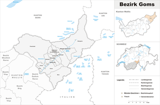
Goms District
Hiking in Goms District
Goms District, located in the Valais region of Switzerland, is a stunning destination for hiking enthusiasts. Known for its picturesque landscapes, charming villages, and rich cultural heritage, Goms offers a variety of hiking trails suited for different skill levels....
- Страна:
- Столица: Münster-Geschinen
- Код автомобильного номера: VS
- Координаты: 46° 27' 0" N, 8° 18' 0" E
- GPS треки (wikiloc): [Ссылка]
- Высота над уровнем моря: 1407 м m
- Площадь: 588.3 кв.км


Сурсельва
Hiking in Сурсельва
Surselva District, located in the canton of Graubünden in Switzerland, is an excellent destination for hiking enthusiasts, known for its stunning natural landscapes, diverse terrain, and rich cultural heritage. Here are some highlights and tips for hiking in the Surselva area:...
- Страна:
- Код автомобильного номера: GR
- Координаты: 46° 46' 0" N, 9° 12' 0" E
- GPS треки (wikiloc): [Ссылка]
- Высота над уровнем моря: 2379 м m
- Площадь: 1373.54 кв.км