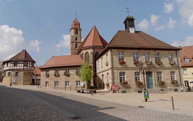
Фюрт (Fürth, Landkreis Fürth)
.svg)
 Hiking in Фюрт
Fürth, located in Bavaria, Germany, offers a variety of hiking opportunities that cater to different skill levels and preferences. The area is characterized by beautiful hills, forests, and rivers, making it a great spot for outdoor enthusiasts.
Hiking Trails
-
Frankenweg Trail: This long-distance hiking trail passes through Northern Bavaria, including the Fürth district. It's a great option for those looking for a multi-day hike as it offers scenic views and a chance to explore various towns and villages along the way.
-
Nature Reserves and Parks: The Fürth district has several nature reserves and parks that provide shorter, well-marked trails. The Fürther Stadtwald (Fürth City Forest) is a lovely area for hiking, with paths winding through lush forest, perfect for a leisurely day hike.
-
Regnitz River Trails: There are several trails along the Regnitz River, ideal for combining a relaxing hike with beautiful water views. This area is also great for cycling.
-
Hiking with Family: For family-friendly hikes, look for shorter trails with gentle terrains suitable for children. Many parks in the area have designated paths that are accessible and provide facilities for families.
Preparation and Tips
- Weather: Be aware of the weather conditions before heading out, as they can change rapidly. Dressing in layers is advisable.
- Trail Maps: It's a good idea to carry a trail map or a GPS device, as some trails may not be well marked.
- Local Flora and Fauna: Take the time to appreciate the local wildlife and plant life, but also be mindful of staying on designated paths to protect natural habitats.
- Safety: Always let someone know your hiking plans and expected return time, especially if you’re tackling longer or more remote trails.
Additional Activities
Aside from hiking, the Fürth district provides opportunities for bird watching, picnicking, and photography, allowing visitors to fully enjoy the natural beauty of the area. The town of Fürth itself has historical sites and cultural activities, making it a good base for your hiking adventures.
Whether you're a local resident or a visitor, hiking in Fürth offers a delightful way to explore the natural landscape while enjoying the fresh air and scenic vistas of Bavaria.
- Страна:

- Столица: Цирндорф
- Код автомобильного номера: FÜ
- Координаты: 49° 25' 0" N, 10° 50' 0" E


- GPS треки (wikiloc): [Ссылка]
- Высота над уровнем моря: 397 м m
- Площадь: 308.00 кв.км
- Население: 116193
- Веб сайт: http://www.landkreis-fuerth.de/
- Википедия русская: wiki(ru)
- Википедия английская: wiki(en)
- Википедия национальная: wiki(de)
- Хранилище Wikidata: Wikidata: Q10455
- Катеория в википедии: [Ссылка]
- Карты в википедии: [Ссылка]
- код Freebase: [/m/01q0s7]
- код GeoNames: Альт: [3220801]
- код VIAF: Альт: [125553050]
- ID отношения в OpenStreetMap: [62778]
- код GND: Альт: [4086563-0]
- идентификатор местоположения ArchINFORM: [4234]
- код LCNAF: Альт: [n85127769]
- код TGN: [7077317]
- Bavarikon ID: [ODB_A00000097]
- код NUTS: [DE258]
- код BabelNet: [02224535n]
- код района Германии: 09573
Включает регионы:

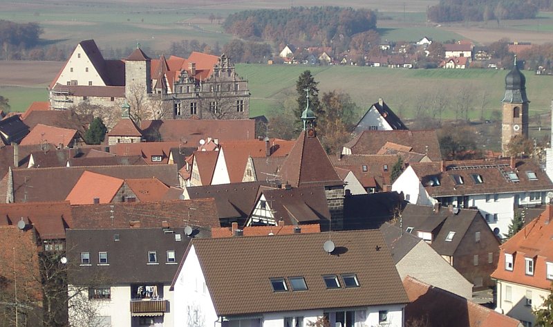
Лангенценн
- город в Германии, в земле Бавария
Hiking in Лангенценн
Langenzenn, located in Bavaria, Germany, offers a charming experience for hiking enthusiasts. The area is characterized by its picturesque landscapes, rolling hills, lush forests, and quaint rural scenery. Here are some highlights and tips for hiking in Langenzenn:...
- Страна:
- Почтовый код: 90579
- Телефонный код: 09101
- Координаты: 49° 29' 40" N, 10° 47' 41" E
- GPS треки (wikiloc): [Ссылка]
- Высота над уровнем моря: 313 м m
- Площадь: 46.31 кв.км
- Население: 8193
- Веб сайт: [Ссылка]


Зойкендорф
Hiking in Зойкендорф
Seukendorf, located in Bavaria, Germany, is a small town that offers a peaceful and scenic environment for hiking enthusiasts. While it may not be as well-known as some of the larger hiking destinations in the region, it provides a quaint and charming backdrop for walking and exploring nature....
- Страна:
- Почтовый код: 90556
- Телефонный код: 0911
- Координаты: 49° 29' 0" N, 10° 53' 0" E
- GPS треки (wikiloc): [Ссылка]
- Высота над уровнем моря: 328 м m
- Площадь: 8.48 кв.км
- Население: 2103
- Веб сайт: [Ссылка]


Аммерндорф
Hiking in Аммерндорф
Ammerndorf, a quaint village in Germany, offers a range of hiking opportunities for nature lovers and outdoor enthusiasts. While the village itself is small, it is situated in the picturesque Franconian region, which provides access to beautiful landscapes, forests, and trails that can be explored. Here are some key pointers for hiking in and around Ammerndorf:...
- Страна:
- Почтовый код: 90614
- Телефонный код: 09127
- Координаты: 49° 25' 15" N, 10° 51' 5" E
- GPS треки (wikiloc): [Ссылка]
- Высота над уровнем моря: 316 м m
- Площадь: 5.06 кв.км
- Население: 1286
- Веб сайт: [Ссылка]


Оберасбах
Hiking in Оберасбах
Oberasbach, located in Bavaria, Germany, offers a variety of hiking opportunities set against the backdrop of the beautiful Franconian landscapes. While it might not be as well-known for hiking as some other areas in Bavaria, it still provides access to scenic trails and paths that appeal to nature lovers....
- Страна:
- Почтовый код: 90522
- Телефонный код: 0911
- Координаты: 49° 25' 19" N, 10° 57' 30" E
- GPS треки (wikiloc): [Ссылка]
- Высота над уровнем моря: 316 м m
- Площадь: 12.08 кв.км
- Население: 14833
- Веб сайт: [Ссылка]


Тухенбах
Hiking in Тухенбах
Tuchenbach is a charming region located in Germany, offering a variety of hiking opportunities for outdoor enthusiasts. While it might not be as widely known as some of the more prominent hiking destinations in Germany, it does feature beautiful landscapes and trails that cater to hikers of all skill levels....
- Страна:
- Почтовый код: 90587
- Телефонный код: 0911
- Координаты: 49° 31' 41" N, 10° 51' 35" E
- GPS треки (wikiloc): [Ссылка]
- Высота над уровнем моря: 345 м m
- Площадь: 6.48 кв.км
- Население: 944
- Веб сайт: [Ссылка]


Обермихельбах
Hiking in Обермихельбах
Obermichelbach, a charming village located in Bavaria, Germany, offers beautiful hiking opportunities amidst picturesque landscapes, rolling hills, and scenic trails. Here are some highlights for hiking in the area:...
- Страна:
- Почтовый код: 90587
- Телефонный код: 0911
- Координаты: 49° 31' 51" N, 10° 54' 36" E
- GPS треки (wikiloc): [Ссылка]
- Высота над уровнем моря: 327 м m
- Площадь: 9.27 кв.км
- Население: 1795
- Веб сайт: [Ссылка]

Пушендорф
Hiking in Пушендорф
Puschendorf is a charming village located in the Franconia region of Germany, and while it may not be as widely known for hiking as some larger areas, it has a lot to offer for outdoor enthusiasts. The surrounding landscapes are picturesque, with rolling hills, forests, and fields that can provide trails suitable for various levels of hikers....
- Страна:
- Почтовый код: 90617
- Телефонный код: 09101
- Координаты: 49° 31' 22" N, 10° 49' 50" E
- GPS треки (wikiloc): [Ссылка]
- Высота над уровнем моря: 363 м m
- Площадь: 3.40 кв.км
- Население: 1582
- Веб сайт: [Ссылка]


Гросхаберсдорф
Hiking in Гросхаберсдорф
Großhabersdorf is a small municipality located in Bavaria, Germany, providing a picturesque backdrop for outdoor activities, including hiking. The area is characterized by rolling hills, forests, and scenic landscapes, making it an excellent destination for nature enthusiasts and hikers of all levels....
- Страна:
- Почтовый код: 90611–90613
- Телефонный код: 09105
- Координаты: 49° 24' 15" N, 10° 47' 17" E
- GPS треки (wikiloc): [Ссылка]
- Высота над уровнем моря: 341 м m
- Площадь: 35.50 кв.км
- Население: 3429
- Веб сайт: [Ссылка]

Росталь
Hiking in Росталь
Roßtal, located in the beautiful state of Bavaria, Germany, is an excellent destination for hiking enthusiasts. The area boasts picturesque landscapes, including lush forests, rolling hills, and charming villages, making it a wonderful spot for both casual walkers and serious hikers....
- Страна:
- Почтовый код: 90574
- Телефонный код: 09127
- Координаты: 49° 24' 0" N, 10° 53' 0" E
- GPS треки (wikiloc): [Ссылка]
- Высота над уровнем моря: 373 м m
- Площадь: 44.40 кв.км
- Население: 8006
- Веб сайт: [Ссылка]

Кадольцбург
Hiking in Кадольцбург
Cadolzburg, located in Bavaria, Germany, offers some lovely hiking opportunities with scenic views and a rich historical backdrop. Here are some aspects to consider for a hiking trip in and around Cadolzburg:...
- Страна:
- Почтовый код: 90556
- Телефонный код: 09103
- Координаты: 49° 27' 0" N, 10° 52' 0" E
- GPS треки (wikiloc): [Ссылка]
- Высота над уровнем моря: 352 м m
- Площадь: 45.39 кв.км
- Население: 8003
- Веб сайт: [Ссылка]


Штейн
Hiking in Штейн
Stein, located in Bavaria, Germany, is a charming area that offers various opportunities for hiking and outdoor activities. Although it is more well-known as a suburb of Nuremberg, there are scenic trails and natural spots in and around the area. Here are some key points to consider for hiking in and around Stein:...
- Страна:
- Почтовый код: 90547
- Телефонный код: 0911
- Координаты: 49° 25' 0" N, 11° 1' 0" E
- GPS треки (wikiloc): [Ссылка]
- Высота над уровнем моря: 304 м m
- Площадь: 19.52 кв.км
- Население: 13267
- Веб сайт: [Ссылка]

Файтсбронн
Hiking in Файтсбронн
Veitsbronn is a small municipality located in Bavaria, Germany, known for its picturesque landscapes and nature trails that are excellent for hiking. Here’s what you should know about hiking in the area:...
- Страна:
- Почтовый код: 90587
- Телефонный код: 0911
- Координаты: 49° 30' 45" N, 10° 53' 17" E
- GPS треки (wikiloc): [Ссылка]
- Высота над уровнем моря: 300 м m
- Площадь: 16.16 кв.км
- Население: 5461
- Веб сайт: [Ссылка]


Вильхермсдорф
Hiking in Вильхермсдорф
Wilhermsdorf, located in Bavaria, Germany, is a charming village offering access to several scenic hiking trails and beautiful natural landscapes. Here are some key points about hiking in Wilhermsdorf:...
- Страна:
- Почтовый код: 91452
- Телефонный код: 09102
- Координаты: 49° 29' 11" N, 10° 43' 5" E
- GPS треки (wikiloc): [Ссылка]
- Высота над уровнем моря: 322 м m
- Площадь: 26.64 кв.км
- Население: 3937
- Веб сайт: [Ссылка]


Цирндорф
Hiking in Цирндорф
Zirndorf, located in Bavaria, Germany, is known for its picturesque landscapes and proximity to Franconian Switzerland, making it an attractive destination for hikers. Here are some details about hiking in Zirndorf and the surrounding area:...
- Страна:
- Почтовый код: 90513
- Телефонный код: 0911
- Координаты: 49° 27' 0" N, 10° 57' 0" E
- GPS треки (wikiloc): [Ссылка]
- Высота над уровнем моря: 306 м m
- Площадь: 28780000 кв.км
- Население: 21022
- Веб сайт: [Ссылка]
Граничит с регионами:

Эрланген-Хёхштадт
Hiking in Эрланген-Хёхштадт
Erlangen-Höchstadt is a scenic district in Bavaria, Germany, known for its beautiful landscapes and opportunities for outdoor activities, including hiking. The region offers a mix of rolling hills, woodlands, and agricultural fields, making it suitable for both casual and more adventurous hikers....
- Страна:
- Столица: Эрланген
- Код автомобильного номера: ERH
- Координаты: 49° 40' 12" N, 10° 49' 48" E
- GPS треки (wikiloc): [Ссылка]
- Высота над уровнем моря: 287 м m
- Площадь: 56465.80 кв.км
- Население: 134136
- Веб сайт: [Ссылка]

Рот
- район германии в Германии, Бавария
Hiking in Рот
Roth district, located in Bavaria, Germany, offers a variety of beautiful landscapes and hiking opportunities that appeal to both novice and experienced hikers. The area is characterized by rolling hills, forests, and picturesque views. Here are some highlights and tips for hiking in Roth:...
- Страна:
- Столица: Рот
- Код автомобильного номера: RH; HIP
- Координаты: 49° 15' 0" N, 11° 4' 48" E
- GPS треки (wikiloc): [Ссылка]
- Высота над уровнем моря: 355 м m
- Площадь: 895.00 кв.км
- Население: 103944
- Веб сайт: [Ссылка]

Ансбах
Hiking in Ансбах
Ansbach district, located in the region of Bavaria, Germany, offers a variety of hiking opportunities suitable for different skill levels. The region is characterized by its picturesque landscapes, including rolling hills, forests, and historical sites, making it a great destination for outdoor enthusiasts....
- Страна:
- Столица: Ансбах
- Код автомобильного номера: ROT; FEU; DKB; AN
- Координаты: 49° 19' 48" N, 10° 30' 0" E
- GPS треки (wikiloc): [Ссылка]
- Высота над уровнем моря: 426 м m
- Площадь: 1972.00 кв.км
- Население: 157632
- Веб сайт: [Ссылка]
Нойштадт-ан-дер-Айш-Бад-Виндсхайм
- район в Баварии, Германия
Hiking in Нойштадт-ан-дер-Айш-Бад-Виндсхайм
Neustadt (Aisch)-Bad Windsheim, located in the Franconian region of Bavaria, Germany, offers a variety of scenic hiking opportunities for outdoor enthusiasts. The area is characterized by its picturesque landscapes, charming villages, and the rich cultural heritage of Franconia. Here are some highlights of hiking in this region:...
- Страна:
- Столица: Нойштадт-ан-дер-Айш
- Код автомобильного номера: UFF; SEF; NEA
- Координаты: 49° 34' 48" N, 10° 30' 0" E
- GPS треки (wikiloc): [Ссылка]
- Высота над уровнем моря: 384 м m
- Площадь: 1267.54 кв.км
- Население: 85686
- Веб сайт: [Ссылка]

Нюрнберг
- город в Германии
Hiking in Нюрнберг
Hiking in and around Nuremberg can offer a remarkable blend of urban exploration and natural beauty. Though Nuremberg itself is a city with a rich history, it is surrounded by picturesque landscapes that are perfect for hiking enthusiasts. Here are some highlights and tips for hiking in the region:...
- Страна:
- Почтовый код: 90402–90491
- Телефонный код: 0911
- Код автомобильного номера: N
- Координаты: 49° 27' 10" N, 11° 4' 40" E
- GPS треки (wikiloc): [Ссылка]
- Высота над уровнем моря: 209 м m
- Площадь: 186.45 кв.км
- Население: 515201
- Веб сайт: [Ссылка]

Фюрт
- город в Баварии, Германия
Hiking in Фюрт
Fürth, located in Bavaria, Germany, offers several hiking opportunities that cater to various fitness levels and preferences. While it may not be as well-known as some of the larger cities for hiking, it has its charms and beautiful landscapes....
- Страна:
- Почтовый код: 90768; 90766; 90765; 90763; 90762
- Телефонный код: 0911
- Код автомобильного номера: FÜ
- Координаты: 49° 28' 42" N, 10° 59' 25" E
- GPS треки (wikiloc): [Ссылка]
- Высота над уровнем моря: 296 м m
- Площадь: 63.35 кв.км
- Население: 125403
- Веб сайт: [Ссылка]
Эрланген
- город в Германии
Hiking in Эрланген
Erlangen, located in Bavaria, Germany, is surrounded by beautiful landscapes that offer various hiking opportunities. While the city itself is relatively flat, the nearby Franconian Switzerland region and the hills of the Fichtelgebirge provide excellent trails for hikers of all skill levels....
- Страна:
- Почтовый код: 91001; 91058; 91057; 91056; 91055; 91054; 91053; 91052
- Телефонный код: 09132; 09135; 0911; 09131
- Код автомобильного номера: ER
- Координаты: 49° 35' 47" N, 11° 0' 16" E
- GPS треки (wikiloc): [Ссылка]
- Высота над уровнем моря: 279 м m
- Площадь: 76900000 кв.км
- Население: 108336
- Веб сайт: [Ссылка]