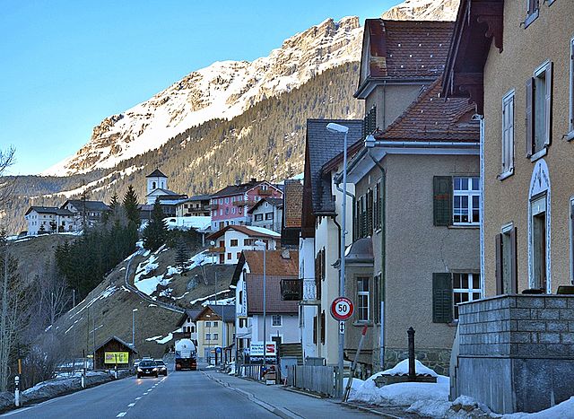
Филизур (Filisur, Filisur)

 Hiking in Филизур
Filisur is a picturesque village located in the canton of Graubünden, Switzerland. It is nestled in the Albula Valley and is known for its stunning landscapes, traditional Swiss architecture, and access to numerous hiking trails. Here are some highlights and tips for hiking in and around Filisur:
Hiking Trails
-
Albula Trail:
- This scenic trail follows the Albula River and showcases beautiful views of the valley, mountains, and local flora and fauna. It is suitable for various skill levels.
-
Rhaetian Railway Trail:
- This hike allows you to explore areas around the historic Rhaetian Railway, where you can appreciate the engineering marvels and breathtaking views.
-
Filisur to Dürrenstein:
- A moderately challenging hike that takes you through charming landscapes and offers beautiful views of the surrounding mountains.
-
Schwarzhorn:
- For those looking for a more challenging hike, the ascent to Schwarzhorn offers rewarding panoramas and the sense of achievement that comes with a higher elevation.
Tips for Hiking in Filisur
-
Trail Conditions: Always check the trail conditions before heading out, as weather can change rapidly in the mountains.
-
Gear: Wear sturdy hiking boots and dress in layers. Bring plenty of water, snacks, and a first aid kit.
-
Maps and Guides: It’s advisable to have a detailed map of the hiking trails. Local tourist offices might offer guided hikes or information on trail conditions.
-
Season: The best times to hike in Filisur are during the spring, summer, and early autumn when the weather is generally stable, and the trails are accessible.
-
Wildlife: Keep an eye out for local wildlife but remember to observe from a distance and respect nature.
Local Amenities
Filisur has several accommodation options, including hotels, guesthouses, and holiday apartments. There are also local restaurants where you can enjoy traditional Swiss cuisine after a day of hiking.
Cultural Aspects
While hiking, you may encounter traditional Swiss chalets and barns, offering a glimpse into local culture and history. The village itself is charming, making it a pleasant place to explore before or after venturing into the trails.
Overall, Filisur offers a blend of natural beauty, recreational activities, and cultural experiences, making it a wonderful destination for hikers of all levels. Enjoy your time in this scenic region!
- Страна:

- Почтовый код: 7477
- Телефонный код: 081
- Код автомобильного номера: GR
- Координаты: 46° 40' 20" N, 9° 41' 15" E


- GPS треки (wikiloc): [Ссылка]
- Высота над уровнем моря: 1032 м m
- Площадь: 44.58 кв.км
- Население: 434
- Веб сайт: http://www.filisur.ch
- Википедия русская: wiki(ru)
- Википедия английская: wiki(en)
- Википедия национальная: wiki(de)
- Хранилище Wikidata: Wikidata: Q66214
- Катеория в википедии: [Ссылка]
- код Freebase: [/m/026fkfd]
- код GeoNames: Альт: [2660776]
- код VIAF: Альт: [129203551]
- ID отношения в OpenStreetMap: [1684078]
- идентификатор местоположения ArchINFORM: [10203]
- код LCNAF: Альт: [n2003040123]
- идентификатор HDS: [1420]
- код швейцарского муниципалитета: [3522]
Граничит с регионами:


Альваной
Hiking in Альваной
Alvaneu is a picturesque village in the Swiss canton of Graubünden, known for its stunning natural landscapes and outdoor activities, including hiking. The area offers a variety of trails suitable for different skill levels, making it ideal for both beginners and experienced hikers. Here are some highlights of hiking in Alvaneu:...
- Страна:
- Почтовый код: 7492
- Телефонный код: 081
- Код автомобильного номера: GR
- Координаты: 46° 40' 59" N, 9° 38' 59" E
- GPS треки (wikiloc): [Ссылка]
- Высота над уровнем моря: 1181 м m
- Площадь: 35.68 кв.км
- Веб сайт: [Ссылка]


Тифенкастель
Hiking in Тифенкастель
Tiefencastel is a small village located in the beautiful region of Graubünden in Switzerland, known for its stunning landscapes and excellent hiking opportunities. Here’s an overview of what to expect when hiking in and around Tiefencastel:...
- Страна:
- Почтовый код: 7450
- Телефонный код: 081
- Код автомобильного номера: GR
- Координаты: 46° 38' 42" N, 9° 36' 47" E
- GPS треки (wikiloc): [Ссылка]
- Высота над уровнем моря: 1716 м m
- Площадь: 14.85 кв.км
- Веб сайт: [Ссылка]


Савоньин
Hiking in Савоньин
Savognin is a picturesque village located in the Surses valley of the Swiss Alps, and it's a fantastic destination for hiking enthusiasts. The region offers a variety of trails that cater to different skill levels, from easy walks suitable for families to more challenging hikes for seasoned adventurers....
- Страна:
- Почтовый код: 7460
- Телефонный код: 081
- Код автомобильного номера: GR
- Координаты: 46° 34' 53" N, 9° 36' 8" E
- GPS треки (wikiloc): [Ссылка]
- Высота над уровнем моря: 1453 м m
- Площадь: 22.24 кв.км
- Веб сайт: [Ссылка]


Шмиттен
Hiking in Шмиттен
Schmitten is a picturesque village located in the Graubünden region of Switzerland, nestled within the beauty of the Swiss Alps. Hiking in this area offers stunning landscapes, fresh mountain air, and a variety of trails suitable for different skill levels....
- Страна:
- Почтовый код: 7493
- Телефонный код: 081
- Код автомобильного номера: GR
- Координаты: 46° 41' 14" N, 9° 40' 20" E
- GPS треки (wikiloc): [Ссылка]
- Высота над уровнем моря: 1699 м m
- Площадь: 11.32 кв.км
- Население: 246
- Веб сайт: [Ссылка]

Тиницонг-Рона
Hiking in Тиницонг-Рона
Tinizong-Rona is a beautiful area located in the canton of Graubünden in Switzerland, known for its stunning landscapes and rich natural biodiversity. Hiking in this region offers a plethora of trails suitable for various skill levels, ranging from beginners to advanced hikers. Here's an overview of what you can expect when hiking in Tinizong-Rona:...
- Страна:
- Почтовый код: 7453
- Телефонный код: 081
- Код автомобильного номера: GR
- Координаты: 46° 35' 0" N, 9° 37' 0" E
- GPS треки (wikiloc): [Ссылка]
- Высота над уровнем моря: 1232 м m
- Площадь: 54.30 кв.км