Савоньин (Savognin, Savognin)

 Hiking in Савоньин
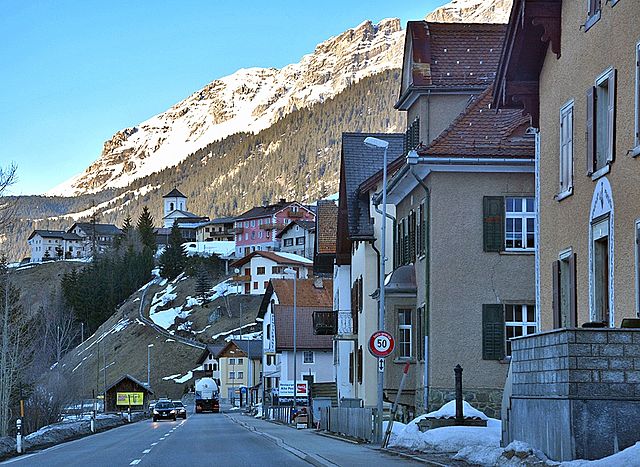
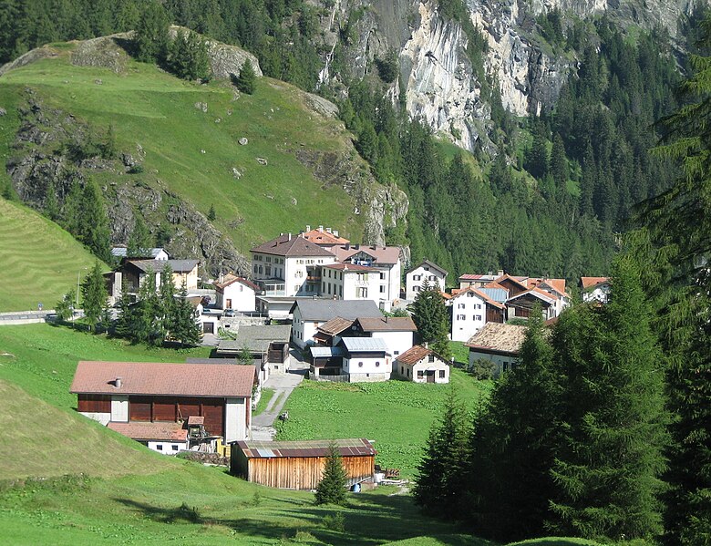
Savognin is a picturesque village located in the Surses valley of the Swiss Alps, and it's a fantastic destination for hiking enthusiasts. The region offers a variety of trails that cater to different skill levels, from easy walks suitable for families to more challenging hikes for seasoned adventurers.
Highlights of Hiking in Savognin:
-
Scenic Landscapes: The area is characterized by stunning alpine scenery, which includes lush meadows, sparkling lakes, and panoramic mountain views. The unique flora and fauna make it a great spot for nature lovers.
-
Well-Marked Trails: Savognin features an extensive network of well-marked hiking trails. The paths are maintained, and information boards can often be found along the routes to guide hikers.
-
Variety of Trails:
- Family-Friendly Hikes: Trails like the "Via Surses" offer relatively easy routes with gentle ascents, making them suitable for families with children.
- Moderate Hikes: For those seeking a bit more of a challenge, trails leading to viewpoints or higher elevations provide rewarding panoramas.
- Challenging Routes: Experienced hikers can take on more demanding trails that venture into the higher elevations, where technical skills and proper gear may be required.
-
Mountain Lakes: Explore the nearby alpine lakes such as the Lago di Savognin, where you can take breaks and enjoy the serene surroundings.
-
Cultural Experiences: Along the hiking routes, you might encounter traditional Swiss huts or experience local culture, including Swiss gastronomy in mountain restaurants.
-
Seasonal Activities: While summer is particularly popular for hiking, Savognin also offers winter hiking and snowshoeing opportunities, allowing for year-round exploration.
-
Wildlife Watching: Keep your eyes peeled for local wildlife, including marmots, chamois, and various bird species, particularly in more secluded areas.
Tips for Hiking in Savognin:
- Weather Awareness: The weather can change rapidly in the mountains, so always check conditions before heading out and be prepared for sudden changes.
- Proper Gear: Wear sturdy hiking boots and dress in layers to adjust to changing temperatures.
- Hydration and Nutrition: Carry enough water and snacks to keep your energy up during your hike.
- Trail Maps: Consider obtaining a trail map or using a hiking app to help navigate the area and ensure you’re on the right path.
- Local Guidance: If you're unfamiliar with the area, consider joining a guided hike or attending local hiking events to benefit from expert knowledge.
Whether you're a beginner or an experienced hiker, Savognin offers an unforgettable hiking experience surrounded by the stunning beauty of the Swiss Alps!
- Страна:

- Почтовый код: 7460
- Телефонный код: 081
- Код автомобильного номера: GR
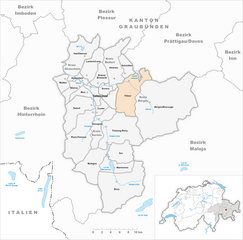
- Координаты: 46° 34' 53" N, 9° 36' 8" E


- GPS треки (wikiloc): [Ссылка]
- Высота над уровнем моря: 1453 м m
- Площадь: 22.24 кв.км
- Веб сайт: http://www.savognin.ch
- Википедия русская: wiki(ru)
- Википедия английская: wiki(en)
- Википедия национальная: wiki(de)
- Хранилище Wikidata: Wikidata: Q65096
- Катеория в википедии: [Ссылка]
- код Freebase: [/m/0dzb_r]
- код GeoNames: Альт: [7287066]
- код VIAF: Альт: [246655785]
- идентификатор HDS: [1429]
- код швейцарского муниципалитета: [3539]
Граничит с регионами:


Кунтер
Hiking in Кунтер
Cunter, a small village in the Grisons region of Switzerland, is an excellent destination for hiking enthusiasts. Nestled amidst stunning landscapes, the area offers a variety of trails suitable for different skill levels, from leisurely walks to more challenging hikes....
- Страна:
- Почтовый код: 7452
- Телефонный код: 081
- Код автомобильного номера: GR
- Координаты: 46° 35' 59" N, 9° 34' 59" E
- GPS треки (wikiloc): [Ссылка]
- Высота над уровнем моря: 1182 м m
- Площадь: 7.12 кв.км
- Население: 215
- Веб сайт: [Ссылка]


Тифенкастель
Hiking in Тифенкастель
Tiefencastel is a small village located in the beautiful region of Graubünden in Switzerland, known for its stunning landscapes and excellent hiking opportunities. Here’s an overview of what to expect when hiking in and around Tiefencastel:...
- Страна:
- Почтовый код: 7450
- Телефонный код: 081
- Код автомобильного номера: GR
- Координаты: 46° 38' 42" N, 9° 36' 47" E
- GPS треки (wikiloc): [Ссылка]
- Высота над уровнем моря: 1716 м m
- Площадь: 14.85 кв.км
- Веб сайт: [Ссылка]


Риом-Парсонц
Hiking in Риом-Парсонц
Riom-Parsonz is a picturesque village located in the canton of Graubünden in Switzerland, known for its stunning natural scenery and excellent hiking opportunities. The region offers a combination of lush valleys, alpine meadows, and striking mountain views, making it a fantastic destination for hikers of all levels....
- Страна:
- Почтовый код: 7464; 7463
- Телефонный код: 081
- Код автомобильного номера: GR
- Координаты: 46° 35' 59" N, 9° 33' 59" E
- GPS треки (wikiloc): [Ссылка]
- Высота над уровнем моря: 1257 м m
- Площадь: 55.97 кв.км
- Веб сайт: [Ссылка]

Тиницонг-Рона
Hiking in Тиницонг-Рона
Tinizong-Rona is a beautiful area located in the canton of Graubünden in Switzerland, known for its stunning landscapes and rich natural biodiversity. Hiking in this region offers a plethora of trails suitable for various skill levels, ranging from beginners to advanced hikers. Here's an overview of what you can expect when hiking in Tinizong-Rona:...
- Страна:
- Почтовый код: 7453
- Телефонный код: 081
- Код автомобильного номера: GR
- Координаты: 46° 35' 0" N, 9° 37' 0" E
- GPS треки (wikiloc): [Ссылка]
- Высота над уровнем моря: 1232 м m
- Площадь: 54.30 кв.км

Мулегнс
Hiking in Мулегнс
Mulegns, a picturesque village nestled in the Swiss Alps, offers fantastic hiking opportunities for outdoor enthusiasts. It is known for its stunning alpine scenery, lush meadows, and well-marked trails suitable for various skill levels. Here are some highlights of hiking in Mulegns:...
- Страна:
- Почтовый код: 7455
- Телефонный код: 081
- Код автомобильного номера: GR
- Координаты: 46° 30' 16" N, 9° 34' 46" E
- GPS треки (wikiloc): [Ссылка]
- Высота над уровнем моря: 1952 м m
- Площадь: 33.79 кв.км

Филизур
Hiking in Филизур
Filisur is a picturesque village located in the canton of Graubünden, Switzerland. It is nestled in the Albula Valley and is known for its stunning landscapes, traditional Swiss architecture, and access to numerous hiking trails. Here are some highlights and tips for hiking in and around Filisur:...
- Страна:
- Почтовый код: 7477
- Телефонный код: 081
- Код автомобильного номера: GR
- Координаты: 46° 40' 20" N, 9° 41' 15" E
- GPS треки (wikiloc): [Ссылка]
- Высота над уровнем моря: 1032 м m
- Площадь: 44.58 кв.км
- Население: 434
- Веб сайт: [Ссылка]