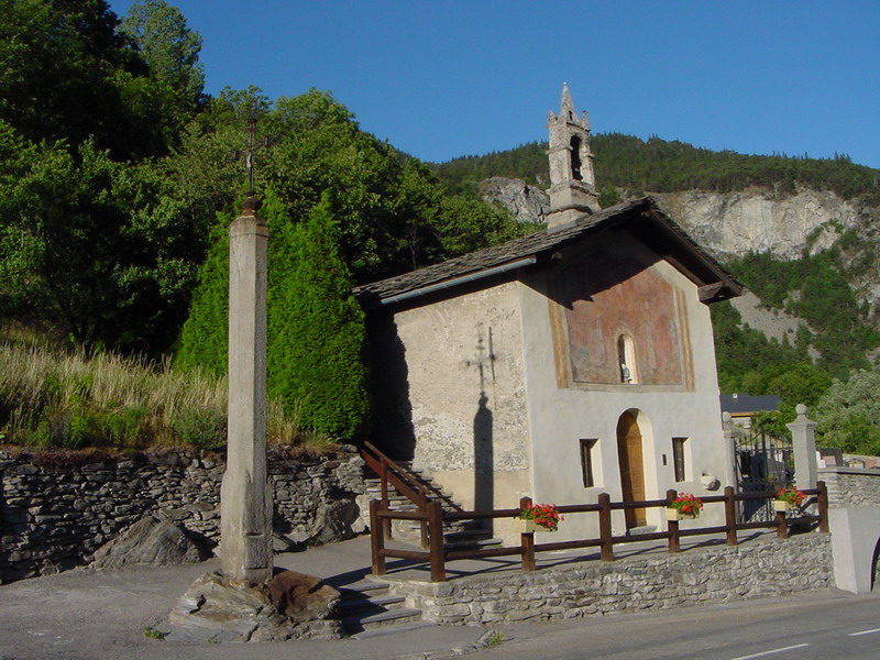
Freney (Freney)

- коммуна во Франции
 Hiking in Freney
Freney, often associated with the broader region of the French Alps, offers stunning scenery and a variety of hiking opportunities. The area is known for its striking mountain landscapes, glacial lakes, and picturesque valleys. Here are some key highlights and tips for hiking in and around Freney:
Hiking Trails:
-
Lac de la Girotte: A beautiful hike that leads you to this serene lake, which provides breathtaking views, especially during sunrise and sunset. The trail is moderate and suitable for most hikers.
-
Mont Aiguille: This is a more challenging hike that rewards you with spectacular views. The trail involves some scrambles, so it’s ideal for experienced hikers looking for a thrill.
-
Les Écrins National Park: Just a short distance from Freney, this national park offers numerous trails ranging from easy walks to strenuous hikes. Popular trails include those leading to the Glacier de la Meije and the Refuge de l'Aigle.
Best Time to Hike:
- Summer (June to September): This is the ideal season for hiking as the weather is usually stable, and the snow has melted from most trails.
- Autumn (September to October): Offers beautiful fall colors, but be mindful of shorter daylight hours and possible early snowfalls.
Tips:
- Gear Up: Wear sturdy hiking boots and dress in layers. The weather can change rapidly in the mountains.
- Hydration: Carry enough water, as well as some snacks, to keep your energy up during the hike.
- Navigation: Have a reliable map or GPS device. Some trails can be less marked, and it’s easy to lose your way.
- Safety: Always inform someone of your hiking plans and estimated return time. It’s also a good idea to check the weather forecast before heading out.
Local Wildlife and Flora:
Keep an eye out for local wildlife, including chamois, marmots, and a variety of birds. The region also features unique alpine flora, which adds to the beauty of the trails.
Overall, hiking in Freney is an adventure filled with natural beauty and diverse trails for all skill levels. Enjoy your exploration!
- Страна:

- Почтовый код: 73500
- Координаты: 45° 11' 38" N, 6° 37' 37" E


- GPS треки (wikiloc): [Ссылка]
- Площадь: 11.13 кв.км
- Население: 105
- Википедия английская: wiki(en)
- Википедия национальная: wiki(fr)
- Хранилище Wikidata: Wikidata: Q1217260
- Катеория в википедии: [Ссылка]
- код Freebase: [/m/03qlmfx]
- код GeoNames: Альт: [6454646]
- номер SIREN: [217301191]
- код BNF: [152740536]
- код муниципалитета INSEE: 73119
Граничит с регионами:

Saint-André
Hiking in Saint-André
Saint-André, located in the Savoie region of the French Alps, is an excellent destination for hiking enthusiasts. With its stunning alpine scenery, diverse trails, and rich natural biodiversity, the area offers various hiking opportunities suitable for all skill levels....
- Страна:
- Почтовый код: 73500
- Координаты: 45° 12' 4" N, 6° 37' 9" E
- GPS треки (wikiloc): [Ссылка]
- Площадь: 30.84 кв.км
- Население: 476
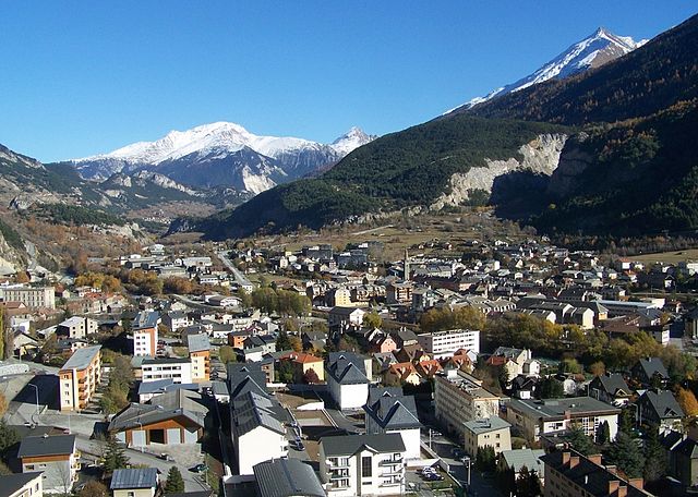

Модан
- коммуна во Франции
Hiking in Модан
Modane is a picturesque town located in the Savoie region of the French Alps, known for its stunning landscapes and proximity to various outdoor activities, including hiking. Here are some key points to consider if you're planning to hike in and around Modane:...
- Страна:
- Почтовый код: 73500
- Координаты: 45° 12' 5" N, 6° 40' 24" E
- GPS треки (wikiloc): [Ссылка]
- Высота над уровнем моря: 1000 м m
- Площадь: 71.04 кв.км
- Население: 3180
- Веб сайт: [Ссылка]


Fourneaux
Hiking in Fourneaux
Fourneaux, located in the Savoie region of the French Alps, offers a variety of hiking opportunities for outdoor enthusiasts. The area is characterized by stunning alpine scenery, including mountains, valleys, and lush forests. Here are some key points to consider if you're planning a hiking trip in Fourneaux:...
- Страна:
- Почтовый код: 73500
- Координаты: 45° 11' 29" N, 6° 39' 6" E
- GPS треки (wikiloc): [Ссылка]
- Площадь: 5.04 кв.км
- Население: 666


Orelle
- коммуна во Франции
Hiking in Orelle
Orelle, a picturesque village located in the French Alps, is an excellent destination for hiking enthusiasts. It is situated near the Maurienne Valley and provides access to a variety of trails that cater to all skill levels, from beginners to advanced hikers....
- Страна:
- Почтовый код: 73140
- Координаты: 45° 12' 33" N, 6° 32' 13" E
- GPS треки (wikiloc): [Ссылка]
- Площадь: 69.25 кв.км
- Население: 352