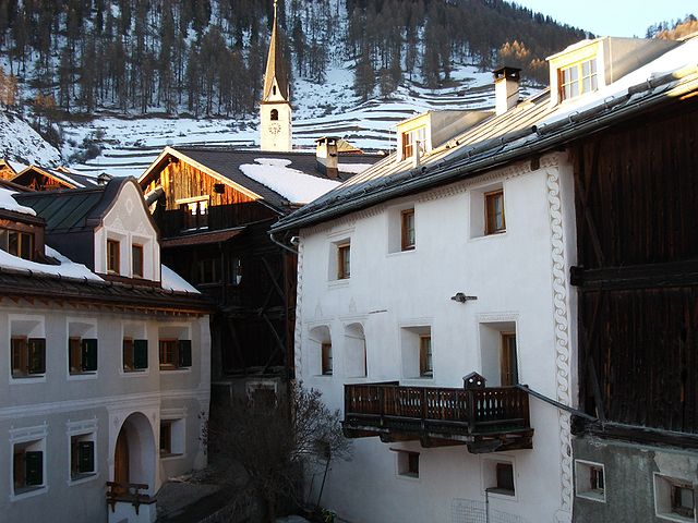
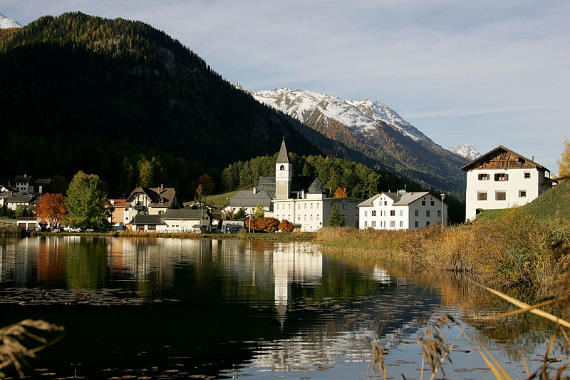
Фтан (Ftan, Ftan)

 Hiking in Фтан
Ftan is a picturesque village located in the Swiss Alps, specifically in the canton of Graubünden. It's renowned for its stunning landscapes and offers a variety of hiking trails suitable for different skill levels. Here's what you should know about hiking in Ftan:
Trails and Routes
-
Ftan to Scuol: This trail offers breathtaking views of the Lower Engadine Valley. The picturesque path leads you through meadows and forests, with opportunities to see local wildlife.
-
Ftan Mountain Trails: There are several trails that take you to the surrounding peaks, offering panoramic views of the Alps. These routes can vary in difficulty, catering to both leisure hikers and more experienced adventurers.
-
Munt Baselgia: A popular hike that takes you to Munt Baselgia, providing excellent views and a refreshing experience in nature. The trails are well-marked.
-
Rhaetian Railway Trail: This is a scenic long-distance trail that intersects Ftan, giving hikers a taste of the historical railway while enjoying stunning vistas.
Best Time to Hike
- Summer (June to September): The weather is generally mild and trails are mostly accessible. This is the ideal time for day hikes.
- Autumn (October): The foliage can be stunning, but be prepared for cooler temperatures and the potential for early snow at higher elevations.
Preparation
- Gear: Sturdy hiking boots and weather-appropriate clothing are essential. Trekking poles can also be beneficial, particularly on steep or uneven terrain.
- Navigation: Most trails are well-marked, but having a map or GPS device is advisable for safety.
Local Experiences
Ftan is also known for its charming atmosphere. After a day of hiking, you can enjoy local cuisine at one of the village restaurants or visit cultural sites. The region has a rich history and breathtaking architecture that can enhance your overall experience.
Safety Tips
- Always check the weather forecast before heading out.
- Start early in the day to allow for ample time to complete your hike before it gets dark.
- Inform someone of your hiking plans, especially if you're going on longer or less-traveled routes.
No matter your hiking level, Ftan and its surrounding areas offer a delightful experience for nature lovers and adventure seekers alike. Enjoy your hikes!
- Страна:

- Почтовый код: 7551
- Телефонный код: 081
- Код автомобильного номера: GR
- Координаты: 46° 49' 33" N, 10° 13' 41" E


- GPS треки (wikiloc): [Ссылка]
- Высота над уровнем моря: 2751 м m
- Площадь: 43.08 кв.км
- Веб сайт: http://www.ftan.ch
- Википедия русская: wiki(ru)
- Википедия английская: wiki(en)
- Википедия национальная: wiki(de)
- Хранилище Wikidata: Wikidata: Q65375
- Галерея изображений в википедии: [Ссылка]
- Катеория в википедии: [Ссылка]
- код Freebase: [/m/0bvvjp]
- код GeoNames: Альт: [7285874]
- идентификатор HDS: [1529]
- код швейцарского муниципалитета: [3761]
Граничит с регионами:

Ардец
Hiking in Ардец
Ardez is a picturesque village located in the Swiss Alps, specifically in the Lower Engadine region of Switzerland. Surrounded by stunning mountain landscapes, Ardez is an excellent destination for hiking enthusiasts. Here are some things to consider for hiking in and around Ardez:...
- Страна:
- Почтовый код: 7546
- Телефонный код: 081
- Код автомобильного номера: GR
- Координаты: 46° 46' 29" N, 10° 12' 3" E
- GPS треки (wikiloc): [Ссылка]
- Высота над уровнем моря: 1362 м m
- Площадь: 61.39 кв.км
- Веб сайт: [Ссылка]


Рамош
Hiking in Рамош
Ramosch is a charming village in the Swiss canton of Graubünden, nestled in the picturesque Lower Engadine Valley. The area is famous for its stunning landscapes, rich cultural heritage, and extensive hiking trails, making it a fantastic destination for hiking enthusiasts....
- Страна:
- Почтовый код: 7556
- Телефонный код: 081
- Код автомобильного номера: GR
- Координаты: 46° 49' 59" N, 10° 23' 0" E
- GPS треки (wikiloc): [Ссылка]
- Высота над уровнем моря: 1236 м m
- Площадь: 84.02 кв.км
- Веб сайт: [Ссылка]

Тарасп
Hiking in Тарасп
Tarasp is a beautiful village in the Lower Engadine region of Switzerland, renowned for its stunning landscapes and rich cultural heritage. It’s an excellent destination for hiking enthusiasts, offering trails that cater to various skill levels, from easy walks to challenging hikes....
- Страна:
- Почтовый код: 7553
- Телефонный код: 081
- Код автомобильного номера: GR
- Координаты: 46° 46' 40" N, 10° 15' 37" E
- GPS треки (wikiloc): [Ссылка]
- Высота над уровнем моря: 2658 м m
- Площадь: 46.99 кв.км
- Веб сайт: [Ссылка]


Скуоль
Hiking in Скуоль
Scuol, located in the Swiss Engadin Valley, is a stunning destination for hiking enthusiasts. The area is known for its beautiful landscapes, picturesque alpine villages, and rich cultural heritage. Here are some highlights and tips for hiking in Scuol:...
- Страна:
- Почтовый код: 7550
- Телефонный код: 081
- Код автомобильного номера: GR
- Координаты: 46° 47' 49" N, 10° 17' 58" E
- GPS треки (wikiloc): [Ссылка]
- Высота над уровнем моря: 2368 м m
- Площадь: 438.63 кв.км
- Население: 4598
- Веб сайт: [Ссылка]


Зент
Hiking in Зент
Sent, a charming village located in the Upper Engadin region of Switzerland, is known for its stunning landscapes, well-marked hiking trails, and rich culture. Here’s an overview of what you can expect when hiking in Sent:...
- Страна:
- Почтовый код: 7554
- Телефонный код: 081
- Код автомобильного номера: GR
- Координаты: 46° 49' 0" N, 10° 20' 0" E
- GPS треки (wikiloc): [Ссылка]
- Высота над уровнем моря: 1440 м m
- Площадь: 111.74 кв.км
- Веб сайт: [Ссылка]