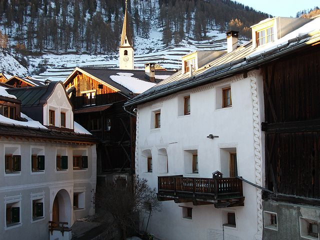
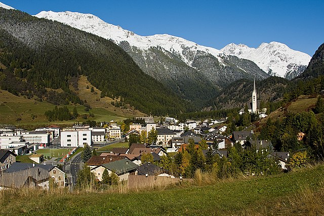
Тарасп (Tarasp, Tarasp)

 Hiking in Тарасп
Tarasp is a beautiful village in the Lower Engadine region of Switzerland, renowned for its stunning landscapes and rich cultural heritage. It’s an excellent destination for hiking enthusiasts, offering trails that cater to various skill levels, from easy walks to challenging hikes.
Hiking Trails
-
Tarasp - Scuol:
- Difficulty: Easy to moderate
- Distance: About 10 km
- Description: This trail connects Tarasp to the nearby village of Scuol, taking you through lush meadows and offering breathtaking views of the surrounding mountains. It’s suitable for families and those looking for a less strenuous hike.
-
Hike to the Tarasp Castle:
- Difficulty: Moderate
- Duration: 1 hour (one way)
- Description: The route to Tarasp Castle is steep but rewarding. The castle dates back to the 12th century and provides panoramic views of the Engadine valley. The trail is well-marked and the historical aspect adds a cultural experience to your hike.
-
Val d'Uina:
- Difficulty: Moderate to challenging
- Duration: 5-6 hours
- Description: This trail takes you through the dramatic Valley of Uina, known for its unique rock formations and stunning natural beauty. The hike involves some elevation gain and can be more demanding, but the landscapes, including waterfalls and alpine meadows, are worth the effort.
-
Mot tail Val Sinestra:
- Difficulty: Moderate
- Duration: 3-4 hours
- Description: The trail leads to the picturesque Val Sinestra, a secluded valley with scenic views. It’s a great option for those looking to escape the busier trails and experience tranquility in nature.
Essentials to Bring
- Proper Footwear: Hiking boots with good grip and ankle support are recommended.
- Weather Gear: The weather can change rapidly in the Alps, so bring a waterproof jacket and layers.
- Hydration: Carry sufficient water, especially for longer hikes.
- Snacks: Energy bars or trail mix are great for keeping your energy levels up.
- Navigation: A map or GPS device can help keep you on track.
Best Time to Visit
The ideal time for hiking in Tarasp is from late spring to early autumn (May to October). During this period, the trails are usually well marked and accessible. The summer months are particularly popular due to pleasant weather and vibrant alpine flora.
Additional Tips
- Local Guides: If you're unfamiliar with the area, consider hiring a local guide for a more informative experience.
- Cultural Aspects: Take the time to explore Tarasp’s cultural sites, such as the castle and local churches, which provide insight into the region’s history.
Whether you're an experienced hiker or just looking for a scenic walk, Tarasp has something to offer everyone. Enjoy your hiking adventure in this beautiful part of Switzerland!
- Страна:

- Почтовый код: 7553
- Телефонный код: 081
- Код автомобильного номера: GR
- Координаты: 46° 46' 40" N, 10° 15' 37" E


- GPS треки (wikiloc): [Ссылка]
- Высота над уровнем моря: 2658 м m
- Площадь: 46.99 кв.км
- Веб сайт: http://www.tarasp.ch
- Википедия русская: wiki(ru)
- Википедия английская: wiki(en)
- Википедия национальная: wiki(de)
- Хранилище Wikidata: Wikidata: Q68372
- Катеория в википедии: [Ссылка]
- код Freebase: [/m/0bpv9v]
- код GeoNames: Альт: [7287279]
- код VIAF: Альт: [240799458]
- идентификатор местоположения ArchINFORM: [9732]
- идентификатор HDS: [1524]
- код швейцарского муниципалитета: [3745]
Граничит с регионами:

Ардец
Hiking in Ардец
Ardez is a picturesque village located in the Swiss Alps, specifically in the Lower Engadine region of Switzerland. Surrounded by stunning mountain landscapes, Ardez is an excellent destination for hiking enthusiasts. Here are some things to consider for hiking in and around Ardez:...
- Страна:
- Почтовый код: 7546
- Телефонный код: 081
- Код автомобильного номера: GR
- Координаты: 46° 46' 29" N, 10° 12' 3" E
- GPS треки (wikiloc): [Ссылка]
- Высота над уровнем моря: 1362 м m
- Площадь: 61.39 кв.км
- Веб сайт: [Ссылка]

Цернец
Hiking in Цернец
Zernez is a beautiful village located in the Swiss National Park in the Engadin Valley, known for its stunning natural landscapes, diverse ecosystems, and a variety of hiking trails that cater to different skill levels. Here are some highlights and tips for hiking in Zernez:...
- Страна:
- Почтовый код: 7530
- Телефонный код: 081
- Код автомобильного номера: GR
- Координаты: 46° 41' 59" N, 10° 5' 59" E
- GPS треки (wikiloc): [Ссылка]
- Высота над уровнем моря: 2216 м m
- Площадь: 344.04 кв.км
- Население: 1532
- Веб сайт: [Ссылка]


Фтан
Hiking in Фтан
Ftan is a picturesque village located in the Swiss Alps, specifically in the canton of Graubünden. It's renowned for its stunning landscapes and offers a variety of hiking trails suitable for different skill levels. Here's what you should know about hiking in Ftan:...
- Страна:
- Почтовый код: 7551
- Телефонный код: 081
- Код автомобильного номера: GR
- Координаты: 46° 49' 33" N, 10° 13' 41" E
- GPS треки (wikiloc): [Ссылка]
- Высота над уровнем моря: 2751 м m
- Площадь: 43.08 кв.км
- Веб сайт: [Ссылка]


Скуоль
Hiking in Скуоль
Scuol, located in the Swiss Engadin Valley, is a stunning destination for hiking enthusiasts. The area is known for its beautiful landscapes, picturesque alpine villages, and rich cultural heritage. Here are some highlights and tips for hiking in Scuol:...
- Страна:
- Почтовый код: 7550
- Телефонный код: 081
- Код автомобильного номера: GR
- Координаты: 46° 47' 49" N, 10° 17' 58" E
- GPS треки (wikiloc): [Ссылка]
- Высота над уровнем моря: 2368 м m
- Площадь: 438.63 кв.км
- Население: 4598
- Веб сайт: [Ссылка]