.jpg)
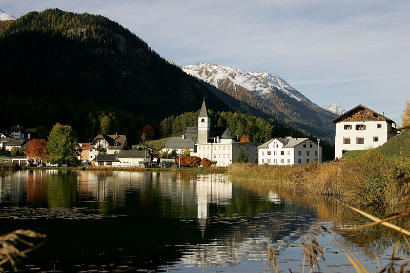
Скуоль (Scuol, Scuol)

 Hiking in Скуоль
Scuol, located in the Swiss Engadin Valley, is a stunning destination for hiking enthusiasts. The area is known for its beautiful landscapes, picturesque alpine villages, and rich cultural heritage. Here are some highlights and tips for hiking in Scuol:
Trails and Routes
-
National Park Trails: The Swiss National Park is nearby and offers a variety of trails that range from easy walks to challenging hikes. The park is known for its diverse flora and fauna, as well as breathtaking mountain views.
-
Lower Engadin Trails: Scuol has several well-marked trails in the Lower Engadin region. Options include routes that lead to traditional huts, waterfalls, and scenic viewpoints.
-
Motta Naluns: This area can be accessed via a cable car and features several trails that vary in difficulty, with stunning views over the valley and surrounding peaks.
-
The Via Engiadina: A long-distance trail that runs through the whole Engadin Valley, offering both leisurely and challenging sections.
Recommendations
-
Season: The best time for hiking in Scuol is during the summer months, typically from late June to September, when the weather is more stable, and the trails are fully accessible.
-
Equipment: Bring proper hiking gear, including sturdy boots, weather-appropriate clothing, and a good backpack. Trekking poles can also be helpful on some of the more challenging trails.
-
Water and Food: Ensure you carry enough water and snacks. While some routes have mountain huts, it’s best to be prepared, especially for the longer hikes.
-
Navigation: Make sure to have a good map or GPS app, as some trails might not be as marked, especially in more remote areas.
Cultural Highlights
While hiking, take the opportunity to explore local cultures, such as the Romansh language and architecture. Scuol has charming villages with traditional Engadine houses, and you may encounter local artisans and cuisine along the way.
Safety Considerations
Always check the weather forecast before heading out, and inform someone about your hiking plans. Mountain weather can change rapidly. It’s also wise to stay on marked trails to preserve nature and ensure your safety.
With its breathtaking scenery and well-maintained trails, Scuol offers an unforgettable hiking experience for outdoor lovers of all levels. Enjoy your adventure!
- Страна:

- Почтовый код: 7550
- Телефонный код: 081
- Код автомобильного номера: GR
- Координаты: 46° 47' 49" N, 10° 17' 58" E


- GPS треки (wikiloc): [Ссылка]
- Высота над уровнем моря: 2368 м m
- Площадь: 438.63 кв.км
- Население: 4598
- Веб сайт: http://www.scuol.net/
- Википедия русская: wiki(ru)
- Википедия английская: wiki(en)
- Википедия национальная: wiki(de)
- Хранилище Wikidata: Wikidata: Q69079
- Катеория в википедии: [Ссылка]
- код Freebase: [/m/0bpvfh]
- код GeoNames: Альт: [7287130]
- код BNF: [119646012]
- код VIAF: Альт: [235911607]
- ID отношения в OpenStreetMap: [4447223]
- идентификатор местоположения ArchINFORM: [43574]
- место в MusicBrainz: [d9d18aa7-eaa2-4b1e-8d4d-9143745160ed]
- идентификатор HDS: [1530]
- код швейцарского муниципалитета: [3762]
Граничит с регионами:


Маллес-Веноста
- коммуна Италии
Hiking in Маллес-Веноста
Mals, located in the Vinschgau Valley in South Tyrol, Italy, is a fantastic spot for hiking enthusiasts. Surrounded by stunning landscapes, picturesque villages, and a rich cultural heritage, it offers a variety of trails suitable for different skill levels....
- Страна:

- Почтовый код: 39024
- Телефонный код: 0473
- Код автомобильного номера: BZ
- Координаты: 46° 41' 16" N, 10° 32' 48" E
- GPS треки (wikiloc): [Ссылка]
- Высота над уровнем моря: 1051 м m
- Площадь: 247.43 кв.км
- Население: 5225
- Веб сайт: [Ссылка]


Тубре
- коммуна в Италии
Hiking in Тубре
Taufers im Münstertal, located in the Bavarian Alps in South Tyrol, Italy, offers a stunning backdrop for hiking enthusiasts of all levels. The area is characterized by its picturesque valleys, lush forests, and panoramic mountain views, making it an ideal destination for nature lovers....
- Страна:
- Почтовый код: 39020
- Телефонный код: 0473
- Код автомобильного номера: BZ
- Координаты: 46° 38' 39" N, 10° 27' 48" E
- GPS треки (wikiloc): [Ссылка]
- Высота над уровнем моря: 1240 м m
- Площадь: 46.27 кв.км
- Население: 981
- Веб сайт: [Ссылка]


Фтан
Hiking in Фтан
Ftan is a picturesque village located in the Swiss Alps, specifically in the canton of Graubünden. It's renowned for its stunning landscapes and offers a variety of hiking trails suitable for different skill levels. Here's what you should know about hiking in Ftan:...
- Страна:
- Почтовый код: 7551
- Телефонный код: 081
- Код автомобильного номера: GR
- Координаты: 46° 49' 33" N, 10° 13' 41" E
- GPS треки (wikiloc): [Ссылка]
- Высота над уровнем моря: 2751 м m
- Площадь: 43.08 кв.км
- Веб сайт: [Ссылка]

Тарасп
Hiking in Тарасп
Tarasp is a beautiful village in the Lower Engadine region of Switzerland, renowned for its stunning landscapes and rich cultural heritage. It’s an excellent destination for hiking enthusiasts, offering trails that cater to various skill levels, from easy walks to challenging hikes....
- Страна:
- Почтовый код: 7553
- Телефонный код: 081
- Код автомобильного номера: GR
- Координаты: 46° 46' 40" N, 10° 15' 37" E
- GPS треки (wikiloc): [Ссылка]
- Высота над уровнем моря: 2658 м m
- Площадь: 46.99 кв.км
- Веб сайт: [Ссылка]


Зент
Hiking in Зент
Sent, a charming village located in the Upper Engadin region of Switzerland, is known for its stunning landscapes, well-marked hiking trails, and rich culture. Here’s an overview of what you can expect when hiking in Sent:...
- Страна:
- Почтовый код: 7554
- Телефонный код: 081
- Код автомобильного номера: GR
- Координаты: 46° 49' 0" N, 10° 20' 0" E
- GPS треки (wikiloc): [Ссылка]
- Высота над уровнем моря: 1440 м m
- Площадь: 111.74 кв.км
- Веб сайт: [Ссылка]