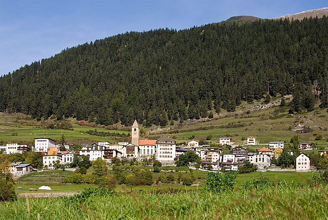
Зент (Sent, Sent)

 Hiking in Зент
Sent, a charming village located in the Upper Engadin region of Switzerland, is known for its stunning landscapes, well-marked hiking trails, and rich culture. Here’s an overview of what you can expect when hiking in Sent:
Hiking Trails
-
Variety of Difficulty Levels: Sent offers trails suitable for all levels of hikers, from easy walks to challenging mountain hikes. Whether you’re a beginner or an experienced hiker, you’ll find something that fits your skill level.
-
Scenic Routes: The trails provide breathtaking views of the Swiss Alps, lush meadows, and picturesque landscapes. Many routes offer panoramic views of the surrounding regions, including the well-known Lakes of the Engadin.
-
Cultural Experience: Hiking in Sent is not just about nature; it’s also a cultural journey. The village has preserved some traditional buildings and offers insight into the local customs and heritage. You might encounter local artisans or farmers during your hike.
-
Themed Trails: Some trails focus on specific themes, such as nature, history, or culture, which can enrich your hiking experience. These may include information boards along the paths to educate hikers about the local flora, fauna, and history.
Important Tips
-
Check the Weather: The weather in the Alps can change rapidly, so it’s essential to check the forecast before heading out.
-
Gear Up Appropriately: Wear sturdy hiking boots and bring layers, as temperatures can vary significantly depending on altitude and time of day.
-
Stay Hydrated and Nourished: Bring enough water and snacks, especially for more extended hikes where services may not be available.
-
Respect Nature: Follow marked trails, take your trash with you, and be mindful of wildlife and vegetation.
Accessibility
- Sent is accessible via public transportation, making it easy to reach for a day hike or a longer stay.
- The village also has facilities, such as restaurants and accommodations, providing convenience for hikers.
Seasonal Considerations
- Summer is peak hiking season, with most trails being accessible.
- In late spring and autumn, some higher trails may have snow or be closed, so always check local trail conditions.
Recommendations
For a unique experience, consider taking part in guided hikes or local events, which can provide additional insight into the region's biodiversity and culture. Enjoy your hiking in Sent!
- Страна:

- Почтовый код: 7554
- Телефонный код: 081
- Код автомобильного номера: GR
- Координаты: 46° 49' 0" N, 10° 20' 0" E


- GPS треки (wikiloc): [Ссылка]
- Высота над уровнем моря: 1440 м m
- Площадь: 111.74 кв.км
- Веб сайт: http://www.sent-online.ch
- Википедия русская: wiki(ru)
- Википедия английская: wiki(en)
- Википедия национальная: wiki(de)
- Хранилище Wikidata: Wikidata: Q69709
- Галерея изображений в википедии: [Ссылка]
- Катеория в википедии: [Ссылка]
- код Freebase: [/m/07kkd0]
- код GeoNames: Альт: [7287153]
- код VIAF: Альт: [132201907]
- идентификатор местоположения ArchINFORM: [5970]
- место в MusicBrainz: [e142ae4e-5002-4da9-8a20-ef9df0881159]
- идентификатор HDS: [1531]
- код швейцарского муниципалитета: [3763]
Граничит с регионами:


Курон-Веноста
- коммуна Италии
Hiking in Курон-Веноста
Graun im Vinschgau, located in the beautiful Vinschgau Valley of South Tyrol, Italy, is a fantastic destination for hikers. Surrounded by stunning alpine scenery, including the Ortler Alps and the Texel Group Nature Park, it offers a variety of trails suitable for all skill levels. Here are some highlights and tips for hiking in this region:...
- Страна:

- Почтовый код: 39020
- Телефонный код: 0473
- Код автомобильного номера: BZ
- Координаты: 46° 48' 30" N, 10° 32' 34" E
- GPS треки (wikiloc): [Ссылка]
- Высота над уровнем моря: 1520 м m
- Площадь: 209.65 кв.км
- Население: 2381
- Веб сайт: [Ссылка]


Маллес-Веноста
- коммуна Италии
Hiking in Маллес-Веноста
Mals, located in the Vinschgau Valley in South Tyrol, Italy, is a fantastic spot for hiking enthusiasts. Surrounded by stunning landscapes, picturesque villages, and a rich cultural heritage, it offers a variety of trails suitable for different skill levels....
- Страна:
- Почтовый код: 39024
- Телефонный код: 0473
- Код автомобильного номера: BZ
- Координаты: 46° 41' 16" N, 10° 32' 48" E
- GPS треки (wikiloc): [Ссылка]
- Высота над уровнем моря: 1051 м m
- Площадь: 247.43 кв.км
- Население: 5225
- Веб сайт: [Ссылка]


Рамош
Hiking in Рамош
Ramosch is a charming village in the Swiss canton of Graubünden, nestled in the picturesque Lower Engadine Valley. The area is famous for its stunning landscapes, rich cultural heritage, and extensive hiking trails, making it a fantastic destination for hiking enthusiasts....
- Страна:
- Почтовый код: 7556
- Телефонный код: 081
- Код автомобильного номера: GR
- Координаты: 46° 49' 59" N, 10° 23' 0" E
- GPS треки (wikiloc): [Ссылка]
- Высота над уровнем моря: 1236 м m
- Площадь: 84.02 кв.км
- Веб сайт: [Ссылка]


Фтан
Hiking in Фтан
Ftan is a picturesque village located in the Swiss Alps, specifically in the canton of Graubünden. It's renowned for its stunning landscapes and offers a variety of hiking trails suitable for different skill levels. Here's what you should know about hiking in Ftan:...
- Страна:
- Почтовый код: 7551
- Телефонный код: 081
- Код автомобильного номера: GR
- Координаты: 46° 49' 33" N, 10° 13' 41" E
- GPS треки (wikiloc): [Ссылка]
- Высота над уровнем моря: 2751 м m
- Площадь: 43.08 кв.км
- Веб сайт: [Ссылка]


Скуоль
Hiking in Скуоль
Scuol, located in the Swiss Engadin Valley, is a stunning destination for hiking enthusiasts. The area is known for its beautiful landscapes, picturesque alpine villages, and rich cultural heritage. Here are some highlights and tips for hiking in Scuol:...
- Страна:
- Почтовый код: 7550
- Телефонный код: 081
- Код автомобильного номера: GR
- Координаты: 46° 47' 49" N, 10° 17' 58" E
- GPS треки (wikiloc): [Ссылка]
- Высота над уровнем моря: 2368 м m
- Площадь: 438.63 кв.км
- Население: 4598
- Веб сайт: [Ссылка]

Valsot
Hiking in Valsot
Valsot is a picturesque mountain area located in the Swiss Alps, renowned for its stunning landscapes and extensive network of hiking trails. Here’s an overview of what you can expect when hiking in Valsot:...
- Страна:
- Почтовый код: 7556, 7559
- Телефонный код: 081
- Код автомобильного номера: GR
- Координаты: 46° 50' 0" N, 10° 23' 0" E
- GPS треки (wikiloc): [Ссылка]
- Высота над уровнем моря: 1236 м m
- Площадь: 158.96 кв.км
- Население: 859
- Веб сайт: [Ссылка]