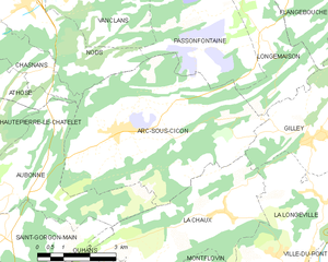
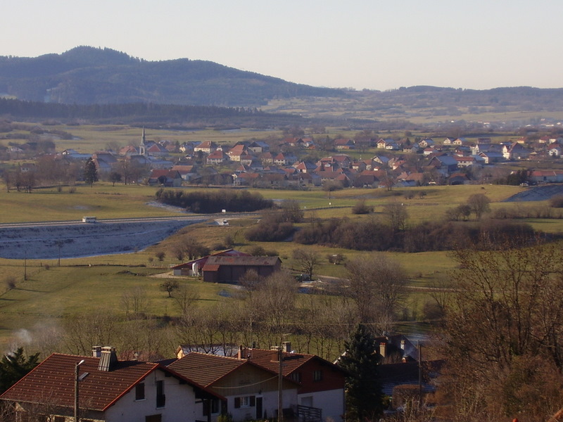
Gilley (Gilley)

 Hiking in Gilley
Gilley is a charming village located in the Doubs department of the Bourgogne-Franche-Comté region in eastern France. It’s a great spot for hiking enthusiasts, offering picturesque landscapes, lush forests, and scenic views of the surrounding Jura mountains.
Here are some highlights and recommendations for hiking in Gilley:
Trails
-
Circuit de Gilley: This is a popular hiking loop that starts in the village and explores the surrounding countryside. It typically features a mix of forest paths and open fields, providing a great opportunity to enjoy the natural beauty and local flora and fauna.
-
Jura Mountain Trails: Many trails lead from Gilley into the larger Jura region. Depending on your skill level, you can find routes that are easy to moderate, suitable for families or more challenging hikes for experienced hikers.
-
Nearby Lakes: Consider hikes that take you to nearby lakes such as Lake Malbuisson or Lake Saint-Point, both offering stunning views and areas to relax or picnic.
Tips for Hiking in Gilley
-
Seasonal Considerations: Spring and summer are ideal for hiking, as the weather is mild and the scenery is vibrant. Autumn offers beautiful foliage, while winter can bring snow, opening up opportunities for snowshoeing or winter hiking.
-
Equipment: Wear suitable hiking shoes and clothing. It’s also advisable to carry water, snacks, and a map or GPS device, especially if you're venturing into less marked trails.
-
Local Regulations: Respect local wildlife and plant life and adhere to any posted regulations regarding camping and trail access.
Experience the Local Culture
Aside from hiking, take advantage of the local culture in Gilley. The region is known for its cheese production (like Comté) and offers charming architecture and local markets to explore.
With its beautiful landscape and variety of hiking paths, Gilley is a delightful destination for outdoor enthusiasts looking to experience the beauty of the French countryside. Enjoy your hiking adventure!
- Страна:

- Почтовый код: 25650
- Координаты: 47° 2' 51" N, 6° 29' 4" E


- GPS треки (wikiloc): [Ссылка]
- Площадь: 17.27 кв.км
- Население: 1615
- Веб сайт: http://www.gilley.fr/
- Википедия английская: wiki(en)
- Википедия национальная: wiki(fr)
- Хранилище Wikidata: Wikidata: Q477767
- Катеория в википедии: [Ссылка]
- код Freebase: [/m/03nnjtf]
- код Freebase: [/m/03nnjtf]
- код GeoNames: Альт: [6429803]
- код GeoNames: Альт: [6429803]
- номер SIREN: [212502710]
- номер SIREN: [212502710]
- код BNF: [152524971]
- код BNF: [152524971]
- код муниципалитета INSEE: 25271
- код муниципалитета INSEE: 25271
Граничит с регионами:


Orchamps-Vennes
- коммуна во Франции
Hiking in Orchamps-Vennes
Orchamps-Vennes is a charming village located in the Doubs department of the Bourgogne-Franche-Comté region in eastern France. This area offers a variety of hiking opportunities that cater to different experience levels, from casual walkers to more experienced hikers....
- Страна:
- Почтовый код: 25390
- Координаты: 47° 8' 3" N, 6° 31' 31" E
- GPS треки (wikiloc): [Ссылка]
- Площадь: 24.79 кв.км
- Население: 2085

Arc-sous-Cicon
- коммуна во Франции
Hiking in Arc-sous-Cicon
Arc-sous-Cicon is a picturesque village located in the Doubs department of the Bourgogne-Franche-Comté region in eastern France. This area is known for its scenic landscapes, rolling hills, forests, and recreational opportunities, particularly for hiking enthusiasts....
- Страна:
- Почтовый код: 25520
- Координаты: 47° 3' 9" N, 6° 22' 52" E
- GPS треки (wikiloc): [Ссылка]
- Площадь: 28.49 кв.км
- Население: 676


Longemaison
- коммуна во Франции
Hiking in Longemaison
Longemaison is a small commune located in the Jura department in east-central France, known for its beautiful natural landscapes and outdoor activities, including hiking. Here are some highlights and tips for hiking in and around Longemaison:...
- Страна:
- Почтовый код: 25690
- Координаты: 47° 4' 54" N, 6° 27' 34" E
- GPS треки (wikiloc): [Ссылка]
- Площадь: 9.63 кв.км
- Население: 146

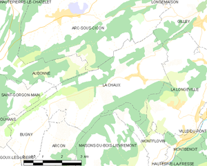
La Chaux
- коммуна во Франции
Hiking in La Chaux
La Chaux is a picturesque region in the Doubs department of France, known for its stunning natural landscapes, including rolling hills, dense forests, and scenic viewpoints. It's a great destination for hiking enthusiasts of all levels. Here are some key points to consider when hiking in La Chaux:...
- Страна:
- Почтовый код: 25650
- Координаты: 47° 1' 23" N, 6° 25' 57" E
- GPS треки (wikiloc): [Ссылка]
- Площадь: 16.94 кв.км
- Население: 497


Les Combes
- коммуна во Франции
Hiking in Les Combes
Les Combes is a charming area perfect for hiking, situated in various regions across Europe. If you mean a specific Les Combes, such as the one in the French Alps or another location, please specify. Generally, hiking in Les Combes offers beautiful natural scenery, diverse trails, and varying levels of difficulty suitable for all kinds of hikers....
- Страна:
- Почтовый код: 25500
- Координаты: 47° 3' 33" N, 6° 32' 40" E
- GPS треки (wikiloc): [Ссылка]
- Площадь: 17.58 кв.км
- Население: 726


Fournets-Luisans
- коммуна во Франции
Hiking in Fournets-Luisans
Fournets-Luisans is a picturesque village located in the Doubs department of the Bourgogne-Franche-Comté region in eastern France. The area around Fournets-Luisans offers a variety of hiking opportunities that cater to different skill levels, making it a great destination for outdoor enthusiasts....
- Страна:
- Почтовый код: 25390
- Координаты: 47° 6' 42" N, 6° 33' 45" E
- GPS треки (wikiloc): [Ссылка]
- Высота над уровнем моря: 913 м m
- Площадь: 27.71 кв.км
- Население: 668


La Longeville
- коммуна во Франции
Hiking in La Longeville
La Longeville is a picturesque area that offers wonderful hiking opportunities, often characterized by its beautiful landscapes, diversity of terrain, and rich natural surroundings. Though specific trails can vary based on the exact location within the area, here are some general aspects to consider when hiking in La Longeville:...
- Страна:
- Почтовый код: 25650
- Координаты: 47° 0' 27" N, 6° 27' 27" E
- GPS треки (wikiloc): [Ссылка]
- Площадь: 15.66 кв.км
- Население: 778
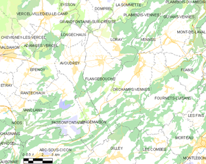
Flangebouche
- коммуна во Франции
Hiking in Flangebouche
Flangebouche, located in the Jura Mountains of France, is a hidden gem for hikers looking for beautiful landscapes, diverse terrain, and a mix of natural and cultural experiences. The region offers numerous trails suitable for all levels of hikers, from beginners to experienced trekkers....
- Страна:
- Почтовый код: 25390
- Координаты: 47° 8' 24" N, 6° 28' 18" E
- GPS треки (wikiloc): [Ссылка]
- Площадь: 23.27 кв.км
- Население: 749