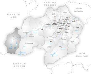
Гуртнеллен (Gurtnellen, Gurtnellen)

- коммуна в Швейцарии
 Hiking in Гуртнеллен
Gurtnellen, located in the picturesque Uri region of Switzerland, is a great destination for hiking enthusiasts. Nestled in the heart of the Swiss Alps, it offers stunning views, varied terrain, and a range of hiking trails suited for different skill levels.
Highlights of Hiking in Gurtnellen:
-
Scenic Views: The area is surrounded by majestic mountains, deep valleys, and lush forests, providing breathtaking panoramas. The combination of natural beauty and tranquility makes hiking here a memorable experience.
-
Trail Variety: You can find a mix of easy to challenging trails. For beginners, there are leisurely walks and well-maintained paths that are suitable for families. More experienced hikers can tackle steeper and more rugged routes that lead to higher elevations.
-
Notable Trails:
- Gurtnellen to the Sustenpass: This popular trail offers beautiful views and varying landscapes. It's a great way to experience the diverse flora and fauna of the region.
- Via Piora: A longer trek that connects Gurtnellen to the Piora Valley, it features impressive alpine scenery and is ideal for those looking for a more extended hiking experience.
- Waterfall Trails: Some shorter trails lead to stunning waterfalls, perfect for a quick hike with scenic rewards.
-
Wildlife: The region is home to diverse wildlife, including ibex, chamois, and various bird species. With a bit of patience, you might spot some of these animals along your hike.
-
Accessibility: Gurtnellen is well-connected by public transportation, making it accessible for hikers coming from nearby towns or cities.
-
Local Culture and Hospitality: After a day of hiking, you can enjoy the local cuisine at mountain restaurants or lodges. The warmth and hospitality of the locals add to the charm of your hiking trip.
Tips for Hiking in Gurtnellen:
- Check Weather Conditions: The weather can change rapidly in the mountains. Always check local forecasts before heading out.
- Dress Appropriately: Wear suitable hiking boots and layers that you can adjust according to the temperature.
- Stay Hydrated and Snack Smart: Carry enough water and packed snacks to keep your energy levels up.
- Follow Trail Markings: Trails are usually well-marked, but it's a good idea to have a map or GPS device to ensure you stay on track.
- Wildlife Safety: Keep a respectful distance from wildlife and avoid feeding animals.
Best Time to Visit:
The hiking season in Gurtnellen typically runs from late spring to early autumn, with the best conditions usually experienced from June to September. Late spring offers blooming wildflowers, while autumn showcases vibrant foliage.
Overall, Gurtnellen is a fantastic hiking destination that combines natural beauty, adventure, and a touch of Swiss culture. Whether you're a casual hiker or an experienced mountaineer, you'll find a trail that suits your interests and skill level. Enjoy your adventure!
- Страна:

- Почтовый код: 6482
- Телефонный код: 041
- Код автомобильного номера: UR
- Координаты: 46° 44' 37" N, 8° 37' 26" E


- GPS треки (wikiloc): [Ссылка]
- Высота над уровнем моря: 1104 м m
- Площадь: 83.35 кв.км
- Население: 558
- Веб сайт: http://www.gurtnellen.ch
- Википедия русская: wiki(ru)
- Википедия английская: wiki(en)
- Википедия национальная: wiki(de)
- Хранилище Wikidata: Wikidata: Q65450
- Катеория в википедии: [Ссылка]
- код Freebase: [/m/0fwq6t]
- код GeoNames: Альт: [7286010]
- код VIAF: Альт: [315579478]
- ID отношения в OpenStreetMap: [1683078]
- идентификатор HDS: [698]
- код швейцарского муниципалитета: [1209]
Граничит с регионами:


Андерматт
- коммуна в Швейцарии
Hiking in Андерматт
Andermatt, nestled in the Swiss Alps, is a captivating hub for hiking enthusiasts. Known for its stunning alpine scenery, Andermatt offers a wide range of trails suitable for various skill levels, from beginners to seasoned hikers....
- Страна:
- Почтовый код: 6490
- Телефонный код: 041
- Код автомобильного номера: UR
- Координаты: 46° 37' 14" N, 8° 37' 53" E
- GPS треки (wikiloc): [Ссылка]
- Высота над уровнем моря: 1753 м m
- Площадь: 62.2 кв.км
- Население: 1354
- Веб сайт: [Ссылка]

Туеч
Hiking in Туеч
Tujetsch is a beautiful municipality located in the canton of Graubünden in Switzerland, known for its stunning landscapes and outdoor recreational opportunities. Hiking in Tujetsch offers a variety of trails suitable for different skill levels, ranging from leisurely walks to more challenging hikes. Here are some highlights and tips for hiking in this picturesque region:...
- Страна:
- Почтовый код: 7188
- Телефонный код: 081
- Код автомобильного номера: GR
- Координаты: 46° 40' 59" N, 8° 46' 0" E
- GPS треки (wikiloc): [Ссылка]
- Высота над уровнем моря: 1450 м m
- Площадь: 134 кв.км
- Население: 1256
- Веб сайт: [Ссылка]

Зиленен
- коммуна в Швейцарии, в кантоне Ури
Hiking in Зиленен
Silenen, a charming municipality in the canton of Uri, Switzerland, is an excellent destination for hiking enthusiasts. Nestled in a picturesque valley, Silenen offers breathtaking views of the surrounding mountains and is a great starting point for various hiking trails suitable for all levels of experience....
- Страна:
- Почтовый код: 6473
- Телефонный код: 041
- Код автомобильного номера: UR
- Координаты: 46° 47' 28" N, 8° 40' 9" E
- GPS треки (wikiloc): [Ссылка]
- Высота над уровнем моря: 510 м m
- Площадь: 144.78 кв.км
- Население: 1991
- Веб сайт: [Ссылка]


Вассен
- коммуна в Швейцарии
Hiking in Вассен
Wassen, located in the beautiful Swiss canton of Uri, is a charming village that serves as a gateway to stunning alpine landscapes and diverse hiking trails. The region is known for its breathtaking mountain scenery, lush meadows, and rich cultural heritage....
- Страна:
- Почтовый код: 6484
- Телефонный код: 041
- Код автомобильного номера: UR
- Координаты: 46° 43' 29" N, 8° 32' 0" E
- GPS треки (wikiloc): [Ссылка]
- Высота над уровнем моря: 1889 м m
- Площадь: 96.89 кв.км
- Население: 422
- Веб сайт: [Ссылка]


Гёшенен
- коммуна в Швейцарии
Hiking in Гёшенен
Göschenen is a picturesque village in the Uri canton of Switzerland, located at the entrance to the Gotthard region, and it offers a variety of hiking opportunities for outdoor enthusiasts. Here are some highlights:...
- Страна:
- Почтовый код: 6487
- Телефонный код: 041
- Код автомобильного номера: UR
- Координаты: 46° 39' 50" N, 8° 29' 56" E
- GPS треки (wikiloc): [Ссылка]
- Высота над уровнем моря: 2430 м m
- Площадь: 10431 кв.км
- Население: 462
- Веб сайт: [Ссылка]


Эрстфельд
- коммуна в Швейцарии
Hiking in Эрстфельд
Erstfeld, located in the canton of Uri in Switzerland, is an excellent destination for hiking enthusiasts. The region is known for its stunning alpine scenery, charming villages, and diverse trails that cater to various skill levels. Here are some highlights of hiking in Erstfeld:...
- Страна:
- Почтовый код: 6472
- Телефонный код: 041
- Код автомобильного номера: UR
- Координаты: 46° 48' 45" N, 8° 35' 58" E
- GPS треки (wikiloc): [Ссылка]
- Высота над уровнем моря: 1067 м m
- Площадь: 59.2 кв.км
- Население: 3781
- Веб сайт: [Ссылка]