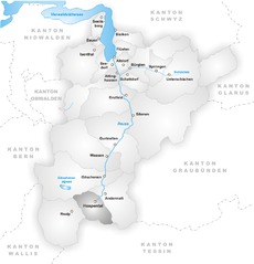
Гёшенен (Göschenen, Göschenen)

- коммуна в Швейцарии
 Hiking in Гёшенен
Göschenen is a picturesque village in the Uri canton of Switzerland, located at the entrance to the Gotthard region, and it offers a variety of hiking opportunities for outdoor enthusiasts. Here are some highlights:
Hiking Trails
-
Gotthard Panorama Trail: This trail is well-known for its stunning views and historical significance, tracing the old routes used by pilgrims and traders. It traverses diverse landscapes, from forests to alpine meadows.
-
Göschenen to the Göscheneralp: This is a popular route that takes you on a scenic hike through the picturesque landscapes of the valley toward the Göscheneralp lake. The trail is accessible for various skill levels.
-
Gämsstock: For those seeking a challenge, hiking to the summit of Gämsstock offers breathtaking panoramic views of the surrounding peaks and valleys. The trail can be more strenuous, so proper preparation is recommended.
-
Alp Vorderberg: A more moderate hike that takes you to charming alpine pastures. This is a great choice for families and those looking for a leisurely stroll with beautiful views.
Tips for Hiking in Göschenen
- Weather: Always check the weather conditions before heading out, as they can change rapidly in the mountains.
- Gear: Ensure you have suitable hiking boots, clothing layers, and enough water and snacks for your hike.
- Navigation: Familiarize yourself with a map or download hiking apps since some trails may not be well marked.
- Wildlife: Keep an eye out for local wildlife, but maintain a safe and respectful distance.
Accessibility and Seasonality
Göschenen is accessible by train and car, making it a convenient base for outdoor activities. The best time for hiking in this region is generally from late spring to early autumn, when trails are clear of snow and weather conditions are favorable.
Whether you're an experienced hiker or just looking for a scenic walk, Göschenen provides a fantastic gateway to the natural beauty of the Swiss Alps.
- Страна:

- Почтовый код: 6487
- Телефонный код: 041
- Код автомобильного номера: UR
- Координаты: 46° 39' 50" N, 8° 29' 56" E


- GPS треки (wikiloc): [Ссылка]
- Высота над уровнем моря: 2430 м m
- Площадь: 10431 кв.км
- Население: 462
- Веб сайт: http://www.goeschenen.ch
- Википедия русская: wiki(ru)
- Википедия английская: wiki(en)
- Википедия национальная: wiki(de)
- Хранилище Wikidata: Wikidata: Q69639
- Катеория в википедии: [Ссылка]
- код Freebase: [/m/037b9c]
- код GeoNames: Альт: [7285944]
- код VIAF: Альт: [246608656]
- ID отношения в OpenStreetMap: [1683079]
- код GND: Альт: [4232484-1]
- идентификатор HDS: [697]
- код швейцарского муниципалитета: [1208]
Граничит с регионами:


Андерматт
- коммуна в Швейцарии
Hiking in Андерматт
Andermatt, nestled in the Swiss Alps, is a captivating hub for hiking enthusiasts. Known for its stunning alpine scenery, Andermatt offers a wide range of trails suitable for various skill levels, from beginners to seasoned hikers....
- Страна:
- Почтовый код: 6490
- Телефонный код: 041
- Код автомобильного номера: UR
- Координаты: 46° 37' 14" N, 8° 37' 53" E
- GPS треки (wikiloc): [Ссылка]
- Высота над уровнем моря: 1753 м m
- Площадь: 62.2 кв.км
- Население: 1354
- Веб сайт: [Ссылка]


Гуртнеллен
- коммуна в Швейцарии
Hiking in Гуртнеллен
Gurtnellen, located in the picturesque Uri region of Switzerland, is a great destination for hiking enthusiasts. Nestled in the heart of the Swiss Alps, it offers stunning views, varied terrain, and a range of hiking trails suited for different skill levels....
- Страна:
- Почтовый код: 6482
- Телефонный код: 041
- Код автомобильного номера: UR
- Координаты: 46° 44' 37" N, 8° 37' 26" E
- GPS треки (wikiloc): [Ссылка]
- Высота над уровнем моря: 1104 м m
- Площадь: 83.35 кв.км
- Население: 558
- Веб сайт: [Ссылка]

Хоспенталь
- коммуна в Швейцарии
Hiking in Хоспенталь
Hospental is a picturesque village located in the Ursern Valley of the Swiss canton of Uri, nestled within the stunning landscapes of the Swiss Alps. Hiking in and around Hospental offers a range of options for all ability levels, from easy, family-friendly trails to more challenging alpine hikes. Here are some highlights and tips about hiking in this beautiful region:...
- Страна:
- Почтовый код: 6493
- Телефонный код: 041
- Код автомобильного номера: UR
- Координаты: 46° 37' 14" N, 8° 34' 12" E
- GPS треки (wikiloc): [Ссылка]
- Высота над уровнем моря: 1493 м m
- Площадь: 35.0 кв.км
- Население: 191
- Веб сайт: [Ссылка]


Реальп
- коммуна в Швейцарии
Hiking in Реальп
Realp is a charming village located in the Uri canton of Switzerland, nestled in the heart of the Swiss Alps. It's an excellent destination for hiking enthusiasts, offering a variety of trails that cater to different skill levels and preferences. Here are some highlights for hiking in and around Realp:...
- Страна:
- Почтовый код: 6491
- Телефонный код: 041
- Код автомобильного номера: UR
- Координаты: 46° 35' 55" N, 8° 30' 11" E
- GPS треки (wikiloc): [Ссылка]
- Высота над уровнем моря: 1538 м m
- Площадь: 78.04 кв.км
- Население: 151
- Веб сайт: [Ссылка]


Гадмен
Hiking in Гадмен
Gadmen is a charming village located in the canton of Bern, Switzerland, and it serves as a fantastic base for a variety of hiking adventures in the surrounding mountainous region of the Central Alps. Here are some key points about hiking in Gadmen:...
- Страна:
- Почтовый код: 3863
- Телефонный код: 033
- Код автомобильного номера: BE
- Координаты: 46° 43' 59" N, 8° 19' 59" E
- GPS треки (wikiloc): [Ссылка]
- Высота над уровнем моря: 1205 м m
- Площадь: 116.4 кв.км
- Веб сайт: [Ссылка]


Вассен
- коммуна в Швейцарии
Hiking in Вассен
Wassen, located in the beautiful Swiss canton of Uri, is a charming village that serves as a gateway to stunning alpine landscapes and diverse hiking trails. The region is known for its breathtaking mountain scenery, lush meadows, and rich cultural heritage....
- Страна:
- Почтовый код: 6484
- Телефонный код: 041
- Код автомобильного номера: UR
- Координаты: 46° 43' 29" N, 8° 32' 0" E
- GPS треки (wikiloc): [Ссылка]
- Высота над уровнем моря: 1889 м m
- Площадь: 96.89 кв.км
- Население: 422
- Веб сайт: [Ссылка]