
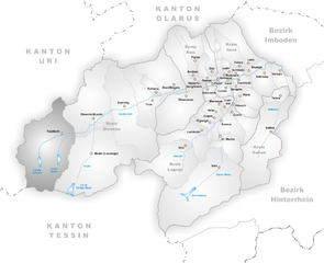
Андерматт (Andermatt, Andermatt)

- коммуна в Швейцарии
 Hiking in Андерматт
Andermatt, nestled in the Swiss Alps, is a captivating hub for hiking enthusiasts. Known for its stunning alpine scenery, Andermatt offers a wide range of trails suitable for various skill levels, from beginners to seasoned hikers.
Key Features of Hiking in Andermatt:
-
Diverse Trails: There are numerous marked trails in the region, including both easy strolls and challenging mountain paths. Some popular routes include:
- Gemstock Hike: This trail takes you to the Gemstock mountain, offering breathtaking views of the surrounding peaks.
- Urserental Valley: A picturesque hike through lush pastures and alongside alpine streams, perfect for a family outing.
- Schöllenen Gorge: This short but intense hike features dramatic rock formations and historic sites.
-
Breathtaking Scenery: Hikers can enjoy stunning landscapes, including rugged mountains, crystal-clear lakes, and lush valleys. The contrasts between the green meadows and the stark mountain peaks make for incredible photographs.
-
Wildlife Watching: The region is home to diverse fauna, such as ibexes, chamois, and various bird species. Hiking quietly enhances your chances of spotting these animals in their natural habitat.
-
Accessibility: Andermatt is well-connected by public transport and has ample facilities for hikers, including accommodation and restaurants. The hiking season typically runs from late spring to early autumn, providing good weather conditions.
-
Guided Tours: For those looking to enhance their experience, guided hiking tours are available, which can provide insight into the local flora, fauna, and geology, as well as tips for safe hiking practices.
-
Altitude and Weather: Be mindful of altitude sickness if you plan to hike at higher elevations. Weather can change rapidly in the mountains, so dressing in layers and being prepared for varying conditions is essential.
-
Safety Tips: Always carry a detailed map or GPS device, inform someone about your hiking plans, and ensure you have enough water and snacks. Check local conditions and trail availability before heading out.
Conclusion
Hiking in Andermatt is a rewarding experience that combines stunning landscapes with the adventure of exploring the Swiss Alps. Whether you are looking for a leisurely walk or an exhilarating climb, Andermatt has something to offer every hiking enthusiast. Always respect nature, follow local guidelines, and most importantly, enjoy your adventure!
- Страна:

- Почтовый код: 6490
- Телефонный код: 041
- Код автомобильного номера: UR
- Координаты: 46° 37' 14" N, 8° 37' 53" E


- GPS треки (wikiloc): [Ссылка]
- Высота над уровнем моря: 1753 м m
- Площадь: 62.2 кв.км
- Население: 1354
- Веб сайт: http://www.gemeinde-andermatt.ch
- Википедия русская: wiki(ru)
- Википедия английская: wiki(en)
- Википедия национальная: wiki(de)
- Хранилище Wikidata: Wikidata: Q64019
- Катеория в википедии: [Ссылка]
- код Freebase: [/m/05znc9]
- код GeoNames: Альт: [7285077]
- код VIAF: Альт: [125952855]
- ID отношения в OpenStreetMap: [1683057]
- идентификатор местоположения ArchINFORM: [18181]
- код LCNAF: Альт: [nr97022561]
- код в Большой каталанской энциклопедии: [0003819]
- идентификатор HDS: [691]
- код швейцарского муниципалитета: [1202]
Граничит с регионами:

Туеч
Hiking in Туеч
Tujetsch is a beautiful municipality located in the canton of Graubünden in Switzerland, known for its stunning landscapes and outdoor recreational opportunities. Hiking in Tujetsch offers a variety of trails suitable for different skill levels, ranging from leisurely walks to more challenging hikes. Here are some highlights and tips for hiking in this picturesque region:...
- Страна:
- Почтовый код: 7188
- Телефонный код: 081
- Код автомобильного номера: GR
- Координаты: 46° 40' 59" N, 8° 46' 0" E
- GPS треки (wikiloc): [Ссылка]
- Высота над уровнем моря: 1450 м m
- Площадь: 134 кв.км
- Население: 1256
- Веб сайт: [Ссылка]


Гуртнеллен
- коммуна в Швейцарии
Hiking in Гуртнеллен
Gurtnellen, located in the picturesque Uri region of Switzerland, is a great destination for hiking enthusiasts. Nestled in the heart of the Swiss Alps, it offers stunning views, varied terrain, and a range of hiking trails suited for different skill levels....
- Страна:
- Почтовый код: 6482
- Телефонный код: 041
- Код автомобильного номера: UR
- Координаты: 46° 44' 37" N, 8° 37' 26" E
- GPS треки (wikiloc): [Ссылка]
- Высота над уровнем моря: 1104 м m
- Площадь: 83.35 кв.км
- Население: 558
- Веб сайт: [Ссылка]

Хоспенталь
- коммуна в Швейцарии
Hiking in Хоспенталь
Hospental is a picturesque village located in the Ursern Valley of the Swiss canton of Uri, nestled within the stunning landscapes of the Swiss Alps. Hiking in and around Hospental offers a range of options for all ability levels, from easy, family-friendly trails to more challenging alpine hikes. Here are some highlights and tips about hiking in this beautiful region:...
- Страна:
- Почтовый код: 6493
- Телефонный код: 041
- Код автомобильного номера: UR
- Координаты: 46° 37' 14" N, 8° 34' 12" E
- GPS треки (wikiloc): [Ссылка]
- Высота над уровнем моря: 1493 м m
- Площадь: 35.0 кв.км
- Население: 191
- Веб сайт: [Ссылка]

Airolo
Hiking in Airolo
Airolo, located in the Ticino canton of Switzerland, is an excellent destination for hiking enthusiasts. It sits at the foot of the Gotthard Pass and offers a variety of trails that cater to different skill levels, from leisurely walks to more challenging treks....
- Страна:
- Почтовый код: 6781; 6780
- Телефонный код: 091
- Код автомобильного номера: TI
- Координаты: 46° 32' 0" N, 8° 37' 0" E
- GPS треки (wikiloc): [Ссылка]
- Высота над уровнем моря: 2132 м m
- Площадь: 94.5 кв.км
- Население: 1527
- Веб сайт: [Ссылка]


Гёшенен
- коммуна в Швейцарии
Hiking in Гёшенен
Göschenen is a picturesque village in the Uri canton of Switzerland, located at the entrance to the Gotthard region, and it offers a variety of hiking opportunities for outdoor enthusiasts. Here are some highlights:...
- Страна:
- Почтовый код: 6487
- Телефонный код: 041
- Код автомобильного номера: UR
- Координаты: 46° 39' 50" N, 8° 29' 56" E
- GPS треки (wikiloc): [Ссылка]
- Высота над уровнем моря: 2430 м m
- Площадь: 10431 кв.км
- Население: 462
- Веб сайт: [Ссылка]