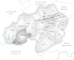
Туеч (Tujetsch, Tujetsch)


 Hiking in Туеч
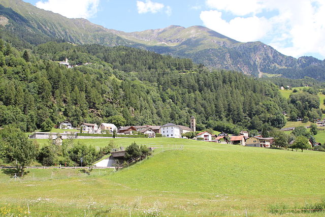
Tujetsch is a beautiful municipality located in the canton of Graubünden in Switzerland, known for its stunning landscapes and outdoor recreational opportunities. Hiking in Tujetsch offers a variety of trails suitable for different skill levels, ranging from leisurely walks to more challenging hikes. Here are some highlights and tips for hiking in this picturesque region:
Scenic Trails
-
Disentis-Mustér: Many hiking routes start from Disentis, a nearby village, leading you through lush valleys and up to panoramic viewpoints. The region is characterized by its rugged mountains, alpine meadows, and serene lakes.
-
Caminada de Via Mala: This scenic trail offers stunning views of the Rhine gorge, making it a fantastic option for those looking for a mix of adventure and beauty.
-
Lake of Toma: A hike to this sparkling alpine lake is ideal for those seeking tranquility. It’s a more moderate hike, with breathtaking scenery perfect for photo opportunities.
-
Parc Ela: The largest nature park in Switzerland is adjacent to Tujetsch and offers numerous hiking trails. You can experience diverse flora and fauna while enjoying the beautiful landscapes.
Trail Difficulty
- Easy Trails: Perfect for families and beginners. These trails are usually well-marked and have gentle slopes.
- Moderate Trails: Ideal for those with some hiking experience. Expect some elevation gain and varied terrain but generally manageable routes.
- Difficult Trails: Suitable for experienced hikers. Be prepared for more rugged paths, steep ascents, and potential exposure to high altitudes.
Best Time to Hike
- Summer (June to September): Enjoy mild weather and fully accessible trails. This is the peak hiking season, so be prepared for more foot traffic.
- Autumn (October): Experience stunning fall foliage, fewer crowds, and crisp, clear weather. However, some trails may start to close due to early snowfall.
- Winter (December to March): While not ideal for traditional hiking, many trails are great for snowshoeing and winter hikes with proper gear.
Preparation Tips
- Gear: Wear sturdy hiking boots, and dress in layers. It can be cooler at higher elevations. Bring a good backpack, sufficient water, snacks, and a basic first-aid kit.
- Navigation: Familiarize yourself with trail maps and markers before heading out. Download offline maps if possible, as cell reception can be spotty in remote areas.
- Safety: Always inform someone about your hiking plans, especially if you're venturing into more isolated areas. Be aware of weather conditions and know your limits.
Local Information
- Guided Tours: Consider joining a guided hiking tour if you're unfamiliar with the area. Local guides can provide valuable insights about the region’s history and wildlife.
- Accommodations: There are various options for staying overnight, from hotels to mountain huts, making it easy to explore multiple trails.
Overall, Tujetsch offers a fantastic hiking experience for nature lovers and outdoor enthusiasts alike. Whether it’s peaceful lakes, majestic mountains, or vibrant wildlife, you’ll find plenty to enjoy while hiking in this stunning part of Switzerland.
- Страна:

- Почтовый код: 7188
- Телефонный код: 081
- Код автомобильного номера: GR
- Координаты: 46° 40' 59" N, 8° 46' 0" E


- GPS треки (wikiloc): [Ссылка]
- Высота над уровнем моря: 1450 м m
- Площадь: 134 кв.км
- Население: 1256
- Веб сайт: http://www.tujetsch.ch
- Википедия русская: wiki(ru)
- Википедия английская: wiki(en)
- Википедия национальная: wiki(de)
- Хранилище Wikidata: Wikidata: Q64280
- Катеория в википедии: [Ссылка]
- код Freebase: [/m/026gmfl]
- код GeoNames: Альт: [7287351]
- код VIAF: Альт: [233920224]
- ID отношения в OpenStreetMap: [1684197]
- идентификатор местоположения ArchINFORM: [43572]
- идентификатор HDS: [1618]
- код швейцарского муниципалитета: [3986]
- LIR: [2956]
Граничит с регионами:


Андерматт
- коммуна в Швейцарии
Hiking in Андерматт
Andermatt, nestled in the Swiss Alps, is a captivating hub for hiking enthusiasts. Known for its stunning alpine scenery, Andermatt offers a wide range of trails suitable for various skill levels, from beginners to seasoned hikers....
- Страна:
- Почтовый код: 6490
- Телефонный код: 041
- Код автомобильного номера: UR
- Координаты: 46° 37' 14" N, 8° 37' 53" E
- GPS треки (wikiloc): [Ссылка]
- Высота над уровнем моря: 1753 м m
- Площадь: 62.2 кв.км
- Население: 1354
- Веб сайт: [Ссылка]

Медель
Hiking in Медель
Medel, located in the municipality of Lucmagn in the Canton of Graubünden, Switzerland, is a stunning area for hiking enthusiasts. The region is characterized by its picturesque landscapes, including dramatic mountains, lush valleys, and tranquil lakes. Here are some key points to consider when planning your hiking trip to Medel:...
- Страна:
- Почтовый код: 7184
- Телефонный код: 081
- Код автомобильного номера: GR
- Координаты: 46° 37' 59" N, 8° 49' 59" E
- GPS треки (wikiloc): [Ссылка]
- Высота над уровнем моря: 1332 м m
- Площадь: 136.22 кв.км
- Население: 384
- Веб сайт: [Ссылка]


Гуртнеллен
- коммуна в Швейцарии
Hiking in Гуртнеллен
Gurtnellen, located in the picturesque Uri region of Switzerland, is a great destination for hiking enthusiasts. Nestled in the heart of the Swiss Alps, it offers stunning views, varied terrain, and a range of hiking trails suited for different skill levels....
- Страна:
- Почтовый код: 6482
- Телефонный код: 041
- Код автомобильного номера: UR
- Координаты: 46° 44' 37" N, 8° 37' 26" E
- GPS треки (wikiloc): [Ссылка]
- Высота над уровнем моря: 1104 м m
- Площадь: 83.35 кв.км
- Население: 558
- Веб сайт: [Ссылка]

Quinto
Hiking in Quinto
Quinto is a picturesque village located in the southern part of Switzerland, specifically in the Ticino canton. This area is renowned for its stunning landscapes, rich natural diversity, and variety of hiking trails. Here are some highlights for hiking in and around Quinto:...
- Страна:
- Почтовый код: 6777
- Телефонный код: 091
- Код автомобильного номера: TI
- Координаты: 46° 31' 0" N, 8° 42' 0" E
- GPS треки (wikiloc): [Ссылка]
- Высота над уровнем моря: 1915 м m
- Площадь: 75.2 кв.км
- Население: 1044
- Веб сайт: [Ссылка]


Дисентис
- курорт в Швейцарии
Hiking in Дисентис
Disentis, located in the Swiss Canton of Graubünden, is a fantastic destination for hiking enthusiasts. This region is known for its breathtaking Alpine scenery, diverse landscapes, and rich cultural heritage. Here are some key points to consider when planning a hiking trip in Disentis:...
- Страна:
- Почтовый код: 7180
- Телефонный код: 081
- Код автомобильного номера: GR
- Координаты: 46° 44' 3" N, 8° 50' 51" E
- GPS треки (wikiloc): [Ссылка]
- Высота над уровнем моря: 1130 м m
- Площадь: 90.98 кв.км
- Население: 2092
- Веб сайт: [Ссылка]

Зиленен
- коммуна в Швейцарии, в кантоне Ури
Hiking in Зиленен
Silenen, a charming municipality in the canton of Uri, Switzerland, is an excellent destination for hiking enthusiasts. Nestled in a picturesque valley, Silenen offers breathtaking views of the surrounding mountains and is a great starting point for various hiking trails suitable for all levels of experience....
- Страна:
- Почтовый код: 6473
- Телефонный код: 041
- Код автомобильного номера: UR
- Координаты: 46° 47' 28" N, 8° 40' 9" E
- GPS треки (wikiloc): [Ссылка]
- Высота над уровнем моря: 510 м m
- Площадь: 144.78 кв.км
- Население: 1991
- Веб сайт: [Ссылка]

Airolo
Hiking in Airolo
Airolo, located in the Ticino canton of Switzerland, is an excellent destination for hiking enthusiasts. It sits at the foot of the Gotthard Pass and offers a variety of trails that cater to different skill levels, from leisurely walks to more challenging treks....
- Страна:
- Почтовый код: 6781; 6780
- Телефонный код: 091
- Код автомобильного номера: TI
- Координаты: 46° 32' 0" N, 8° 37' 0" E
- GPS треки (wikiloc): [Ссылка]
- Высота над уровнем моря: 2132 м m
- Площадь: 94.5 кв.км
- Население: 1527
- Веб сайт: [Ссылка]