Хафен-Сити (HafenCity, HafenCity)

- квартал в Гамбурге, Германия
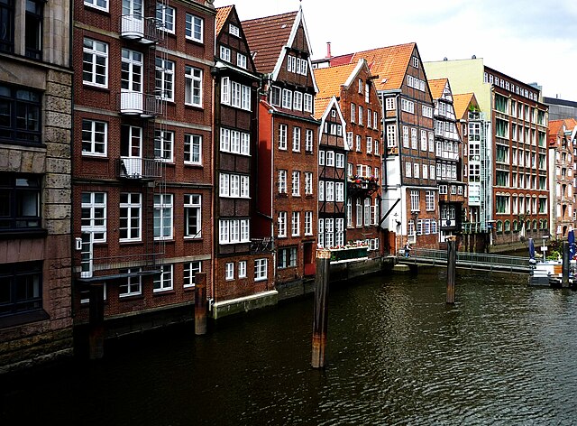
 Hiking in Хафен-Сити
HafenCity is primarily known as a modern urban development project in Hamburg, Germany, rather than a traditional hiking destination. This area features a mix of residential, commercial, and recreational spaces along the waterfront. While it may not offer typical hiking trails like those found in natural parks or mountainous regions, there are still plenty of opportunities for walking and exploring.
Here are a few highlights for exploring HafenCity on foot:
-
Landungsbrücken: Start your journey at the historical Landungsbrücken (Dockland) area. This lively spot offers stunning views of the harbor and is the gateway to explore the waterfront.
-
HafenCity Public Spaces: The development features several parks and promenades. You can stroll along the Elbpromenade, which runs alongside the water and provides scenic views of the harbor, modern architecture, and ship traffic.
-
Dancing Towers (Twisted Pair): As you walk through HafenCity, don't miss the unique architecture, including the famous Dancing Towers. This area is filled with innovative buildings that reflect Hamburg's maritime history and modern design.
-
Elbtunnel: For a unique experience, you can walk through the historic Old Elbe Tunnel (Alter Elbtunnel) that provides a fascinating passage under the Elbe River. It connects the mainland with the southern banks of the river and has pedestrian walkways.
-
Cultural Attractions: HafenCity is home to the Elbphilharmonie, a concert hall with a stunning rooftop plaza that provides panoramic views of the city. Make sure to include this in your walking itinerary.
While HafenCity may not be a hiking destination in the traditional sense, walking around this vibrant urban area can still provide a refreshing experience amid contemporary architecture and waterfront views. If you’re looking for a more natural hiking experience, consider venturing to nearby parks or nature reserves in Hamburg, such as Stadtpark or the nearby Lüneburg Heath.
- Страна:

- Телефонный код: 040
- Координаты: 53° 32' 30" N, 9° 59' 36" E


- GPS треки (wikiloc): [Ссылка]
- Высота над уровнем моря: 8 м m
- Площадь: 2.4 кв.км
- Википедия английская: wiki(en)
- Википедия национальная: wiki(de)
- Хранилище Wikidata: Wikidata: Q1561
- Галерея изображений в википедии: [Ссылка]
- Катеория в википедии: [Ссылка]
- Карты в википедии: [Ссылка]
- код Freebase: [/m/03d940p]
- код GeoNames: Альт: [7932379]
- код VIAF: Альт: [246998764]
- ID отношения в OpenStreetMap: [28931]
- код GND: Альт: [7612107-0]
- идентификатор местоположения ArchINFORM: [16543]
- код LCNAF: Альт: [no2013092798]
- идентификатор Structurae: [10001220]
Граничит с регионами:

Альтштадт
- квартал в Гамбурге
Hiking in Альтштадт
While Hamburg is more renowned for its vibrant culture and historic architecture than for traditional hiking trails, there are still some great opportunities for walking and exploring the city, especially in and around Altstadt (the Old Town)....
- Страна:
- Координаты: 53° 33' 0" N, 10° 0' 0" E
- GPS треки (wikiloc): [Ссылка]
- Высота над уровнем моря: 8 м m
- Площадь: 1.2 кв.км
- Население: 2257
- Веб сайт: [Ссылка]


Нойштадт
- квартал Гамбурга
Hiking in Нойштадт
Neustadt, located within the city limits of Hamburg, is primarily an urban area known for its historical architecture, cultural attractions, and vibrant atmosphere. While Neustadt itself is not typically known for traditional hiking as one might find in national parks or rural settings, there are plenty of opportunities for walking, exploring, and enjoying the outdoors in and around the district....
- Страна:
- Почтовый код: 20459; 20457; 20359; 20355; 20354
- Координаты: 53° 33' 7" N, 9° 59' 8" E
- GPS треки (wikiloc): [Ссылка]
- Высота над уровнем моря: 10 м m
- Площадь: 2.2 кв.км
- Население: 12657
- Веб сайт: [Ссылка]


Малый Грасброк
- квартал Гамбурга, Германия
Hiking in Малый Грасброк
Kleiner Grasbrook is a small island located in the harbor area of Hamburg, Germany. While it may not be a traditional hiking destination like national parks or mountain regions, it does offer opportunities for walking and enjoying the waterfront scenery. Here are a few highlights about the area:...
- Страна:
- Координаты: 53° 31' 52" N, 9° 59' 37" E
- GPS треки (wikiloc): [Ссылка]
- Высота над уровнем моря: 6 м m
- Площадь: 4.5 кв.км
- Население: 1218


Ротенбургсорт
- квартал Гамбурга, Германия
Hiking in Ротенбургсорт
Rothenburgsort is a neighborhood in Hamburg, Germany, and while it isn't primarily known for hiking like more rural areas or national parks, there are still opportunities for walking and exploring the outdoors....
- Страна:
- Координаты: 53° 32' 6" N, 10° 2' 27" E
- GPS треки (wikiloc): [Ссылка]
- Высота над уровнем моря: 3 м m
- Площадь: 7.4 кв.км


Штайнвердер
- квартал Гамбурга, Германия
Hiking in Штайнвердер
Steinwerder is a district in Hamburg, Germany, located on the south banks of the River Elbe. While it may not be a traditional hiking destination with extensive trails, it does offer some opportunities for outdoor activities, particularly along the waterfront and in nearby parks....
- Страна:
- Координаты: 53° 32' 4" N, 9° 57' 26" E
- GPS треки (wikiloc): [Ссылка]
- Высота над уровнем моря: 2 м m
- Площадь: 10.4 кв.км
- Население: 38


Веддель
- район Гамбурга, Германия
Hiking in Веддель
Veddel is a district in Hamburg, Germany, primarily known for its urban environment, so it may not be a traditional hiking destination. However, there are opportunities for pleasant walks and explorations in and around the area. Here are some suggestions for enjoying outdoor activities near Veddel:...
- Страна:
- Координаты: 53° 31' 0" N, 10° 2' 0" E
- GPS треки (wikiloc): [Ссылка]
- Высота над уровнем моря: 25 м m
- Площадь: 4.4 кв.км
- Население: 4632
- Веб сайт: [Ссылка]