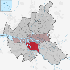
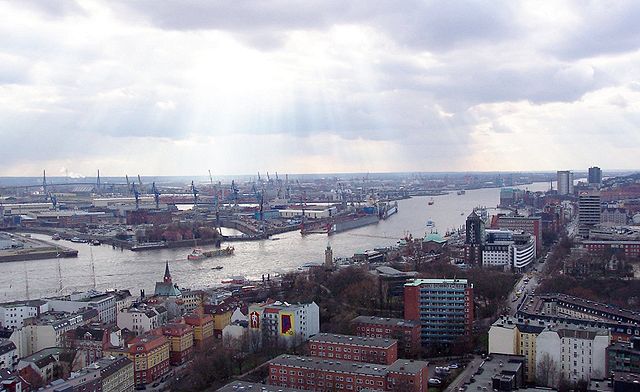
Штайнвердер (Steinwerder, Steinwerder)

- квартал Гамбурга, Германия
 Hiking in Штайнвердер
Steinwerder is a district in Hamburg, Germany, located on the south banks of the River Elbe. While it may not be a traditional hiking destination with extensive trails, it does offer some opportunities for outdoor activities, particularly along the waterfront and in nearby parks.
Here are a few highlights for hiking or walking in the Steinwerder area:
-
Elbe River Walk: You can enjoy scenic walks along the banks of the Elbe, where you might find paths that provide beautiful views of the river and the Hamburg skyline. The riverside promenades are perfect for leisurely strolls.
-
Parks and Green Spaces: In the surrounding areas, you can find several parks that offer green spaces for walking or picnicking. Exploring local parks can allow for a pleasant hike without venturing far from urban amenities.
-
Nearby Attractions: If you're up for a short trip, consider taking a short ferry ride to nearby districts or exploring the picturesque scenery at the Elbe beaches.
-
Bike and Hike: Since the area is relatively flat, it's also great for biking. Combining hiking and biking can allow you to cover more ground while enjoying the scenic Elbe views.
-
Urban Hiking: Steinwerder is part of a larger urban area, so exploring the architecture and urban landscapes can also be fulfilling. This can include walking through different neighborhoods and taking in local culture along the way.
While Steinwerder may not offer extensive hiking trails, it can be a pleasant area to explore on foot, especially for those who appreciate waterfront views and urban environments. Just be sure to wear comfortable shoes and stay hydrated while exploring!
- Страна:

- Координаты: 53° 32' 4" N, 9° 57' 26" E


- GPS треки (wikiloc): [Ссылка]
- Высота над уровнем моря: 2 м m
- Площадь: 10.4 кв.км
- Население: 38
- Википедия английская: wiki(en)
- Википедия национальная: wiki(de)
- Хранилище Wikidata: Wikidata: Q1582
- Галерея изображений в википедии: [Ссылка]
- Катеория в википедии: [Ссылка]
- Карты в википедии: [Ссылка]
- код VIAF: Альт: [238143841]
- ID отношения в OpenStreetMap: [2073754]
Граничит с регионами:

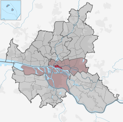
Вильгельмсбург
- район в Гамбурге, Германия
Hiking in Вильгельмсбург
Wilhelmsburg, a district in Hamburg, Germany, is known for its unique blend of nature and urban life. While it may not be a traditional hiking destination like the Alps or national parks, there are still several opportunities for outdoor adventures and exploring scenic routes....
- Страна:
- Координаты: 53° 29' 42" N, 10° 0' 40" E
- GPS треки (wikiloc): [Ссылка]
- Высота над уровнем моря: -2 м m
- Площадь: 35.3 кв.км


Нойштадт
- квартал Гамбурга
Hiking in Нойштадт
Neustadt, located within the city limits of Hamburg, is primarily an urban area known for its historical architecture, cultural attractions, and vibrant atmosphere. While Neustadt itself is not typically known for traditional hiking as one might find in national parks or rural settings, there are plenty of opportunities for walking, exploring, and enjoying the outdoors in and around the district....
- Страна:
- Почтовый код: 20459; 20457; 20359; 20355; 20354
- Координаты: 53° 33' 7" N, 9° 59' 8" E
- GPS треки (wikiloc): [Ссылка]
- Высота над уровнем моря: 10 м m
- Площадь: 2.2 кв.км
- Население: 12657
- Веб сайт: [Ссылка]

Санкт-Паули
- квартал Гамбурга
Hiking in Санкт-Паули
St. Pauli is primarily known as a vibrant and eclectic neighborhood in Hamburg, Germany, famous for its nightlife, cultural scene, and historic sites, rather than traditional hiking areas. However, if you're looking for outdoor activities, there are nearby parks and green spaces ideal for walking and exploring the urban environment. Here are a few options:...
- Страна:
- Координаты: 53° 33' 25" N, 9° 57' 50" E
- GPS треки (wikiloc): [Ссылка]
- Высота над уровнем моря: 17 м m
- Площадь: 2.6 кв.км

Хафен-Сити
- квартал в Гамбурге, Германия
Hiking in Хафен-Сити
HafenCity is primarily known as a modern urban development project in Hamburg, Germany, rather than a traditional hiking destination. This area features a mix of residential, commercial, and recreational spaces along the waterfront. While it may not offer typical hiking trails like those found in natural parks or mountainous regions, there are still plenty of opportunities for walking and exploring....
- Страна:
- Телефонный код: 040
- Координаты: 53° 32' 30" N, 9° 59' 36" E
- GPS треки (wikiloc): [Ссылка]
- Высота над уровнем моря: 8 м m
- Площадь: 2.4 кв.км


Малый Грасброк
- квартал Гамбурга, Германия
Hiking in Малый Грасброк
Kleiner Grasbrook is a small island located in the harbor area of Hamburg, Germany. While it may not be a traditional hiking destination like national parks or mountain regions, it does offer opportunities for walking and enjoying the waterfront scenery. Here are a few highlights about the area:...
- Страна:
- Координаты: 53° 31' 52" N, 9° 59' 37" E
- GPS треки (wikiloc): [Ссылка]
- Высота над уровнем моря: 6 м m
- Площадь: 4.5 кв.км
- Население: 1218


Вальтерсхоф
- квартал в Гамбурге, Германия
Hiking in Вальтерсхоф
Waltershof, located in Germany, is a picturesque area that offers a variety of hiking opportunities. While specifics about trails may vary, here are some general insights for anyone looking to explore hiking in Waltershof:...
- Страна:
- Координаты: 53° 31' 40" N, 9° 54' 2" E
- GPS треки (wikiloc): [Ссылка]
- Высота над уровнем моря: -2 м m
- Площадь: 9.2 кв.км


Альтона-Альтшадт
- район в округе Альтона, Гамбург, Германия
Hiking in Альтона-Альтшадт
Altona-Altstadt is a district in Hamburg, Germany, that offers a mix of urban and natural landscapes, making it an interesting place for hiking. While it may not have extensive hiking trails like more rural areas, there are still opportunities for walking and exploring scenic sites in and around the area....
- Страна:
- Координаты: 53° 32' 56" N, 9° 56' 52" E
- GPS треки (wikiloc): [Ссылка]
- Площадь: 2.8 кв.км