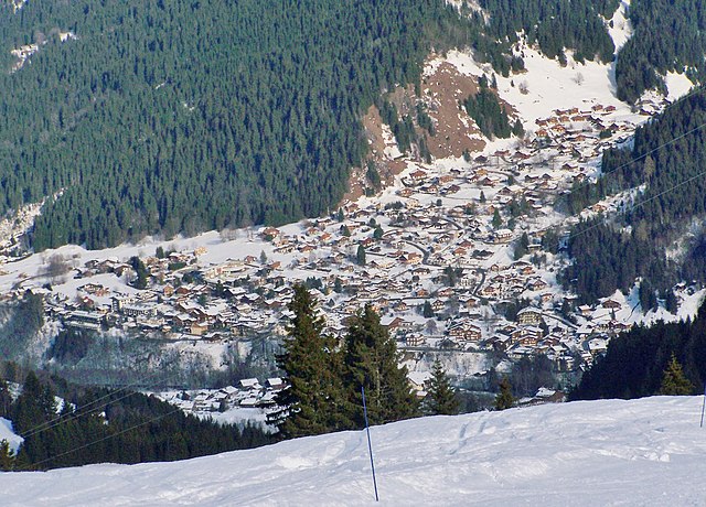
Hauteluce (Hauteluce)

- коммуна во Франции
 Hiking in Hauteluce
Hauteluce is a beautiful commune located in the Savoie region of the French Alps. It's part of the Beaufortain massif, which is known for its stunning landscapes, rich natural environment, and a variety of hiking opportunities. Here’s an overview of what you can expect when hiking in Hauteluce:
Scenic Trails and Routes
-
Beaufortain Regional Nature Park: Many hiking trails in Hauteluce are located within this park, offering a mix of landscapes, including alpine meadows, forests, and stunning views of the surrounding mountains.
-
Lac de la Girotte: This hike takes you to a lovely mountain lake surrounded by splendid scenery. The path is relatively accessible and offers a great option for families and moderate hikers.
-
Col du Joly: This popular hiking route provides breathtaking panoramic views. Depending on the season, you might be greeted by wildflowers or snow-capped peaks.
-
Les Contamines-Montjoie: Just a short distance from Hauteluce, this area offers extensive hiking opportunities with marked trails leading through beautiful scenery.
Hiking Difficulty Levels
- Easy: Many trails around Hauteluce are suitable for beginners and families, featuring gentle slopes and moderate distances.
- Moderate: There are numerous trails for those looking for a challenge, with steeper ascents that reward hikers with exceptional views.
- Difficult: For experienced hikers, the region offers challenging routes that may include significant elevation changes and rugged terrain.
Best Times to Hike
- Summer (June to September): This is the peak hiking season when most trails are clear of snow and the weather is typically warm and pleasant.
- Autumn (Late September to October): The fall foliage adds stunning colors to the landscape, but be prepared for cooler temperatures and potential early snow.
- Winter: While many trails are not accessible during the winter months due to snow, the area is popular for winter sports like skiing and snowshoeing.
Tips for Hiking in Hauteluce
- Prepare for Weather Changes: Mountain weather can be unpredictable. Always check the forecast and dress in layers.
- Stay Hydrated: Bring enough water, especially on longer hikes where access to streams may not be available.
- Navigation: While many trails are well-marked, consider carrying a map or GPS device. MOBILE RECEPTION can be spotty in the mountains.
- Wildlife Awareness: Keep an eye out for local wildlife, but remember to observe from a distance and not feed the animals.
Local Amenities
Hauteluce has various accommodations, restaurants, and shops catering to hikers and tourists. Depending on the season, you can also find local markets selling regional cheeses and other products.
In summary, Hauteluce is a stunning hiking destination for all levels of adventurers, blending natural beauty with various trails that showcase the best of the French Alps. Enjoy your hiking experiences there!
- Страна:

- Почтовый код: 73620
- Координаты: 45° 45' 4" N, 6° 35' 9" E


- GPS треки (wikiloc): [Ссылка]
- Площадь: 62.39 кв.км
- Население: 767
- Википедия английская: wiki(en)
- Википедия национальная: wiki(fr)
- Хранилище Wikidata: Wikidata: Q1093011
- Катеория в википедии: [Ссылка]
- код Freebase: [/m/03npg_p]
- код GeoNames: Альт: [6442806]
- номер SIREN: [217301324]
- код BNF: [15274066j]
- код TGN: [1033419]
- код муниципалитета INSEE: 73132
Граничит с регионами:


Beaufort
Hiking in Beaufort
Beaufort, located in the Savoie region of the French Alps, offers a stunning backdrop for hiking enthusiasts. Known for its picturesque alpine landscapes, the area is characterized by rolling hills, lush meadows, and rugged mountain terrain. Here are some highlights and tips for hiking in Beaufort:...
- Страна:
- Почтовый код: 73270
- Координаты: 45° 43' 5" N, 6° 34' 30" E
- GPS треки (wikiloc): [Ссылка]
- Площадь: 149.53 кв.км
- Население: 2088
Виллар-сюр-Дорон
- коммуна во Франции
Hiking in Виллар-сюр-Дорон
Villard-sur-Doron is a charming village located in the Savoie region of the French Alps, providing a great base for hiking enthusiasts. Nestled in a picturesque valley, it serves as an excellent spot for exploring the natural beauty of the surrounding mountains....
- Страна:
- Почтовый код: 73270
- Координаты: 45° 43' 36" N, 6° 31' 42" E
- GPS треки (wikiloc): [Ссылка]
- Площадь: 22.21 кв.км
- Население: 698
- Веб сайт: [Ссылка]


Межев
- коммуна во Франции
Hiking in Межев
Megève, located in the French Alps, is a charming alpine village that offers a variety of hiking opportunities amidst stunning scenery. With its picturesque mountainous landscapes, lush valleys, and an array of well-marked trails, Megève is a great destination for hikers of all levels....
- Страна:
- Почтовый код: 74120
- Координаты: 45° 51' 25" N, 6° 37' 3" E
- GPS треки (wikiloc): [Ссылка]
- Площадь: 44.11 кв.км
- Население: 3210
- Веб сайт: [Ссылка]

Les Contamines-Montjoie
- коммуна во Франции
Hiking in Les Contamines-Montjoie
Les Contamines-Montjoie is a beautiful alpine village located in the French Alps, known for its stunning mountain scenery, diverse trails, and rich natural environment. Here’s an overview of what you can expect when hiking in this region:...
- Страна:
- Почтовый код: 74170
- Координаты: 45° 49' 18" N, 6° 43' 45" E
- GPS треки (wikiloc): [Ссылка]
- Площадь: 81.35 кв.км
- Население: 1196
- Веб сайт: [Ссылка]


Crest-Voland
- коммуна во Франции
Hiking in Crest-Voland
Crest-Voland is a charming alpine village located in the Savoie region of the French Alps. It offers a fantastic hiking experience due to its stunning mountain landscapes, diverse trails, and the proximity to the Mont Blanc massif. Here are some highlights of hiking in Crest-Voland:...
- Страна:
- Почтовый код: 73590
- Координаты: 45° 47' 42" N, 6° 30' 20" E
- GPS треки (wikiloc): [Ссылка]
- Площадь: 9.96 кв.км
- Население: 374


Cohennoz
- коммуна во Франции
Hiking in Cohennoz
Cohennoz, located in the Savoie region of the French Alps, offers a picturesque setting for hiking enthusiasts. Nestled between valleys and mountains, it features a variety of trails that cater to different experience levels. Here are some key points about hiking in Cohennoz:...
- Страна:
- Почтовый код: 73400
- Координаты: 45° 45' 27" N, 6° 28' 53" E
- GPS треки (wikiloc): [Ссылка]
- Площадь: 13.78 кв.км
- Население: 159


Praz-sur-Arly
- коммуна во Франции
Hiking in Praz-sur-Arly
Praz-sur-Arly is a charming alpine village located in the Haute-Savoie region of France, close to Mont Blanc and the numerous ski resorts of the area. It offers a unique blend of stunning mountain scenery and a variety of outdoor activities, making it an excellent destination for hiking enthusiasts....
- Страна:
- Почтовый код: 74120
- Координаты: 45° 50' 14" N, 6° 34' 12" E
- GPS треки (wikiloc): [Ссылка]
- Площадь: 22.64 кв.км
- Население: 1266


Notre-Dame-de-Bellecombe
- коммуна во Франции
Hiking in Notre-Dame-de-Bellecombe
Notre-Dame-de-Bellecombe, located in the French Alps, is a beautiful destination for hiking with stunning landscapes and a variety of trails suitable for different skill levels. The region is characterized by its lush meadows, alpine flora, and panoramic views of the surrounding mountain ranges....
- Страна:
- Почтовый код: 73590
- Координаты: 45° 48' 34" N, 6° 31' 8" E
- GPS треки (wikiloc): [Ссылка]
- Площадь: 21.45 кв.км
- Население: 486
- Веб сайт: [Ссылка]