%20(cropped).jpg)
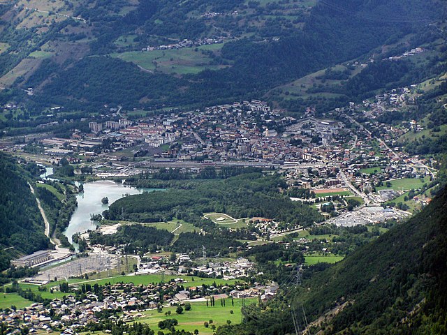
Les Contamines-Montjoie (Les Contamines-Montjoie)

- коммуна во Франции
 Hiking in Les Contamines-Montjoie
Les Contamines-Montjoie is a beautiful alpine village located in the French Alps, known for its stunning mountain scenery, diverse trails, and rich natural environment. Here’s an overview of what you can expect when hiking in this region:
Scenic Trails
- Variety of Routes: Les Contamines offers a range of hiking trails that cater to different skill levels, from leisurely walks to challenging mountain hikes.
- Mont Joly: A popular hike is to Mont Joly, providing panoramic views of the Mont Blanc massif. The trail can be accessed via the Pertuis gondola, making it more accessible for a wider range of hikers.
- Les Contamines Nature Reserve: Explore the rich biodiversity within the nature reserve, where you can often spot unique flora and fauna.
Best Seasons
- Summer (June to September): This is the most popular time for hiking. The trails are clear of snow, and wildflowers bloom, offering colorful vistas.
- Autumn (October): While hiking can still be enjoyable, be prepared for cooler temperatures and potential snowfall as the season progresses.
Preparation
- Pack Essentials: Always carry sufficient water, snacks, a first-aid kit, proper clothing for changing weather, and a map or GPS device.
- Weather Awareness: Mountain weather can change rapidly, so it’s crucial to check forecasts and be prepared for varying conditions.
Local Culture and Amenities
- Mountain Huts: Along the trails, you’ll find mountain huts where you can rest and enjoy traditional French cuisine.
- Cultural Experience: Les Contamines-Montjoie also has a rich local culture with opportunities to learn about alpine traditions and practices.
Guided Tours
For those new to hiking or wanting more in-depth knowledge about the area, consider joining guided tours. Local guides can enhance your experience by sharing insights about the landscape, wildlife, and history.
Before you set off on your hike, make sure to check local maps and trail conditions, as these can help ensure a safe and enjoyable hiking experience. Enjoy the breathtaking beauty of the Alps in Les Contamines-Montjoie!
- Страна:

- Почтовый код: 74170
- Координаты: 45° 49' 18" N, 6° 43' 45" E


- GPS треки (wikiloc): [Ссылка]
- Площадь: 81.35 кв.км
- Население: 1196
- Веб сайт: http://www.mairie-lescontamines.com
- Википедия английская: wiki(en)
- Википедия национальная: wiki(fr)
- Хранилище Wikidata: Wikidata: Q477987
- Катеория в википедии: [Ссылка]
- код Freebase: [/m/08mdqr]
- код GeoNames: Альт: [3001336]
- номер SIREN: [217400852]
- код BNF: [152743442]
- код VIAF: Альт: [158518748]
- код LCNAF: Альт: [n2010069325]
- код муниципалитета INSEE: 74085
Граничит с регионами:


Hauteluce
- коммуна во Франции
Hiking in Hauteluce
Hauteluce is a beautiful commune located in the Savoie region of the French Alps. It's part of the Beaufortain massif, which is known for its stunning landscapes, rich natural environment, and a variety of hiking opportunities. Here’s an overview of what you can expect when hiking in Hauteluce:...
- Страна:
- Почтовый код: 73620
- Координаты: 45° 45' 4" N, 6° 35' 9" E
- GPS треки (wikiloc): [Ссылка]
- Площадь: 62.39 кв.км
- Население: 767


Beaufort
Hiking in Beaufort
Beaufort, located in the Savoie region of the French Alps, offers a stunning backdrop for hiking enthusiasts. Known for its picturesque alpine landscapes, the area is characterized by rolling hills, lush meadows, and rugged mountain terrain. Here are some highlights and tips for hiking in Beaufort:...
- Страна:
- Почтовый код: 73270
- Координаты: 45° 43' 5" N, 6° 34' 30" E
- GPS треки (wikiloc): [Ссылка]
- Площадь: 149.53 кв.км
- Население: 2088

Бур-Сен-Морис
- коммуна во Франции
Hiking in Бур-Сен-Морис
Bourg-Saint-Maurice, located in the Savoie region of the French Alps, is a fantastic destination for hikers. It offers stunning alpine scenery, a variety of trails suitable for different skill levels, and access to some of the most beautiful landscapes in the region, including the Vanoise National Park....
- Страна:
- Почтовый код: 73700
- Координаты: 45° 37' 0" N, 6° 46' 7" E
- GPS треки (wikiloc): [Ссылка]
- Высота над уровнем моря: 744 м m
- Площадь: 179.07 кв.км
- Население: 7228
- Веб сайт: [Ссылка]

Курмайёр
- коммуна Италии
Hiking in Курмайёр
Courmayeur, located in the Aosta Valley of Italy, is a fantastic destination for hikers. Nestled at the foot of Mont Blanc, the area offers a variety of trails that cater to all skill levels, from leisurely walks to challenging alpine hikes. Here are some highlights for hiking in Courmayeur:...
- Страна:

- Почтовый код: 11013
- Телефонный код: 0165
- Код автомобильного номера: AO
- Координаты: 45° 47' 0" N, 6° 58' 0" E
- GPS треки (wikiloc): [Ссылка]
- Высота над уровнем моря: 1224 м m
- Площадь: 210 кв.км
- Население: 2798
- Веб сайт: [Ссылка]


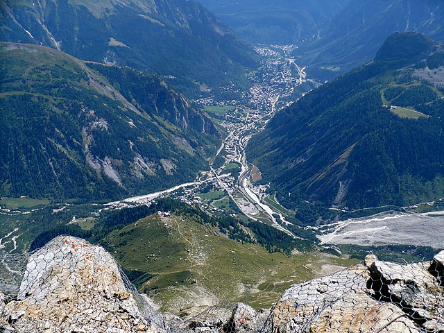
Сен-Жерве-ле-Бен
- коммуна во Франции
Hiking in Сен-Жерве-ле-Бен
Saint-Gervais-les-Bains, located in the Haute-Savoie region of the French Alps, is a fantastic destination for hiking enthusiasts. This charming alpine town is not only known for its ski resort but also offers a myriad of hiking trails suitable for all levels, from beginners to experienced hikers....
- Страна:
- Почтовый код: 74190
- Координаты: 45° 53' 33" N, 6° 42' 49" E
- GPS треки (wikiloc): [Ссылка]
- Площадь: 63.63 кв.км
- Население: 5534
- Веб сайт: [Ссылка]