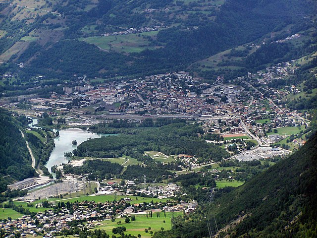
Beaufort (Beaufort)

 Hiking in Beaufort
Beaufort, located in the Savoie region of the French Alps, offers a stunning backdrop for hiking enthusiasts. Known for its picturesque alpine landscapes, the area is characterized by rolling hills, lush meadows, and rugged mountain terrain. Here are some highlights and tips for hiking in Beaufort:
Trails and Routes:
-
Beaufortine Trail: This is a well-marked trail that takes you through beautiful alpine pastures and offers spectacular views of the Mont Blanc massif. It's suitable for all levels and provides options for shorter or longer hikes.
-
Mont Beaufort: A hike to Mont Beaufort rewards you with panoramic views of the surrounding peaks and valleys. The ascent can be challenging, so it's best for those with a moderate level of fitness.
-
Lacs de la Tempête: This hike leads you to picturesque mountain lakes where you can relax and enjoy the tranquility of nature. The route is family-friendly and is great for beginners.
-
From Beaufort to Arêches: This scenic route connects Beaufort to the charming village of Arêches, taking you through forests and offering breathtaking views of the Beaufortain mountains.
Best Time to Hike:
- Summer (June to September): This is the prime hiking season, as the trails are generally clear of snow, and the weather is more stable. Wildflowers bloom, adding vibrant colors to the landscape.
- Early Autumn (September to October): The fall colors can be stunning, and the trails are less crowded, providing a more peaceful hiking experience.
Tips for Hiking in Beaufort:
- Local Weather: Always check the weather forecast before heading out, as alpine weather can change rapidly. Dress in layers to accommodate temperature fluctuations.
- Navigation: While many trails are well-marked, carrying a local hiking map or a GPS device is advisable, especially if you're venturing into less populated areas.
- Safety: Ensure you carry enough water, snacks, and a first-aid kit. Inform someone of your hiking plans if you're going off-grid.
- Wildlife: The region is home to diverse flora and fauna, so be mindful and respectful of the wildlife. Keep a safe distance from animals and do not feed them.
Local Attractions:
Besides hiking, the Beaufort area is famous for its cheese (Beaufort cheese), local architecture, and charming villages. Taking a break from hiking to visit a cheese farm or explore local markets is a rewarding experience.
Always remember to leave no trace, respecting the environment to keep this stunning region beautiful for future generations. Happy hiking!
- Страна:

- Почтовый код: 73270
- Координаты: 45° 43' 5" N, 6° 34' 30" E


- GPS треки (wikiloc): [Ссылка]
- Площадь: 149.53 кв.км
- Население: 2088
- Википедия английская: wiki(en)
- Википедия национальная: wiki(fr)
- Хранилище Wikidata: Wikidata: Q1158013
- Катеория в википедии: [Ссылка]
- код Freebase: [/m/03qllyd]
- код GeoNames: Альт: [6614295]
- номер SIREN: [217300342]
- код BNF: [152739701]
- код LCNAF: Альт: [nr95033320]
- код муниципалитета INSEE: 73034
Граничит с регионами:


Hauteluce
- коммуна во Франции
Hiking in Hauteluce
Hauteluce is a beautiful commune located in the Savoie region of the French Alps. It's part of the Beaufortain massif, which is known for its stunning landscapes, rich natural environment, and a variety of hiking opportunities. Here’s an overview of what you can expect when hiking in Hauteluce:...
- Страна:
- Почтовый код: 73620
- Координаты: 45° 45' 4" N, 6° 35' 9" E
- GPS треки (wikiloc): [Ссылка]
- Площадь: 62.39 кв.км
- Население: 767


La Côte-d'Aime
- коммуна во Франции
Hiking in La Côte-d'Aime
La Côte-d'Aime is a charming commune located in the Savoie region of the French Alps, nestled in the heart of the Tarentaise Valley. This area is known for its breathtaking mountain scenery and a variety of outdoor activities, making it a great destination for hikers. Here are some key points to consider when hiking in La Côte-d'Aime:...
- Страна:
- Почтовый код: 73210
- Координаты: 45° 34' 4" N, 6° 40' 7" E
- GPS треки (wikiloc): [Ссылка]
- Площадь: 26.26 кв.км
- Население: 824
Tours-en-Savoie
- коммуна во Франции
Hiking in Tours-en-Savoie
Tours-en-Savoie is a picturesque commune located in the Savoie department in the Auvergne-Rhône-Alpes region of southeastern France. It serves as a gateway to several hiking opportunities in the stunning landscapes of the French Alps. Here are some key points and recommendations for hiking in and around Tours-en-Savoie:...
- Страна:
- Почтовый код: 73790
- Координаты: 45° 39' 19" N, 6° 26' 24" E
- GPS треки (wikiloc): [Ссылка]
- Площадь: 15.37 кв.км
- Население: 949


Queige
- коммуна во Франции
Hiking in Queige
Queige is a picturesque village located in the French Alps, close to the Beaufortain massif. It offers beautiful landscapes, charming scenery, and a variety of hiking opportunities suitable for different skill levels....
- Страна:
- Почтовый код: 73720
- Координаты: 45° 43' 11" N, 6° 27' 33" E
- GPS треки (wikiloc): [Ссылка]
- Площадь: 32.61 кв.км
- Население: 825
- Веб сайт: [Ссылка]


Granier
- коммуна во Франции
Hiking in Granier
Hiking in Granier, located in the Savoie region of the French Alps, offers a beautiful experience surrounded by stunning landscapes, including lush forests, alpine meadows, and impressive mountain views. Granier is particularly known for its access to the Chartreuse Regional Natural Park and the Bauges Regional Natural Park, which provide a variety of trails suitable for different skill levels....
- Страна:
- Почтовый код: 73210
- Координаты: 45° 34' 21" N, 6° 39' 3" E
- GPS треки (wikiloc): [Ссылка]
- Площадь: 30.31 кв.км
- Население: 364
Виллар-сюр-Дорон
- коммуна во Франции
Hiking in Виллар-сюр-Дорон
Villard-sur-Doron is a charming village located in the Savoie region of the French Alps, providing a great base for hiking enthusiasts. Nestled in a picturesque valley, it serves as an excellent spot for exploring the natural beauty of the surrounding mountains....
- Страна:
- Почтовый код: 73270
- Координаты: 45° 43' 36" N, 6° 31' 42" E
- GPS треки (wikiloc): [Ссылка]
- Площадь: 22.21 кв.км
- Население: 698
- Веб сайт: [Ссылка]


La Léchère
- коммуна во Франции
Hiking in La Léchère
La Léchère, located in the French Alps, is a beautiful destination for hiking enthusiasts. The region is known for its stunning landscapes, which include alpine meadows, serene lakes, and striking mountain peaks. Here are some highlights and tips for hiking in La Léchère:...
- Страна:
- Почтовый код: 73260
- Координаты: 45° 31' 56" N, 6° 28' 24" E
- GPS треки (wikiloc): [Ссылка]
- Площадь: 134.54 кв.км
- Население: 1823


Aime-la-Plagne
Hiking in Aime-la-Plagne
Aime-la-Plagne, located in the French Alps, is a fantastic destination for hiking enthusiasts of all skill levels. Nestled within the Paradiski ski area, this region offers breathtaking views, diverse trails, and a rich Alpine landscape, making it an excellent choice for summer hiking....
- Страна:
- Почтовый код: 73210
- Координаты: 45° 33' 35" N, 6° 39' 6" E
- GPS треки (wikiloc): [Ссылка]
- Площадь: 94.67 кв.км
- Веб сайт: [Ссылка]

Бур-Сен-Морис
- коммуна во Франции
Hiking in Бур-Сен-Морис
Bourg-Saint-Maurice, located in the Savoie region of the French Alps, is a fantastic destination for hikers. It offers stunning alpine scenery, a variety of trails suitable for different skill levels, and access to some of the most beautiful landscapes in the region, including the Vanoise National Park....
- Страна:
- Почтовый код: 73700
- Координаты: 45° 37' 0" N, 6° 46' 7" E
- GPS треки (wikiloc): [Ссылка]
- Высота над уровнем моря: 744 м m
- Площадь: 179.07 кв.км
- Население: 7228
- Веб сайт: [Ссылка]

Les Contamines-Montjoie
- коммуна во Франции
Hiking in Les Contamines-Montjoie
Les Contamines-Montjoie is a beautiful alpine village located in the French Alps, known for its stunning mountain scenery, diverse trails, and rich natural environment. Here’s an overview of what you can expect when hiking in this region:...
- Страна:
- Почтовый код: 74170
- Координаты: 45° 49' 18" N, 6° 43' 45" E
- GPS треки (wikiloc): [Ссылка]
- Площадь: 81.35 кв.км
- Население: 1196
- Веб сайт: [Ссылка]


La Bâthie
- коммуна во Франции
Hiking in La Bâthie
La Bâthie is a charming area located in the Savoie region of France, nestled in the heart of the French Alps. It offers a variety of hiking opportunities suitable for various skill levels, making it a great destination for outdoor enthusiasts....
- Страна:
- Почтовый код: 73540
- Координаты: 45° 37' 37" N, 6° 26' 58" E
- GPS треки (wikiloc): [Ссылка]
- Площадь: 22.45 кв.км
- Население: 2184


Cevins
- коммуна во Франции
Hiking in Cevins
It seems like there may be a typo in your request, as "Cevins" doesn't correspond to a known hiking destination. However, if you meant "Cevins" in the context of a specific region or park, I would be happy to help you with information about that area....
- Страна:
- Почтовый код: 73730
- Координаты: 45° 35' 29" N, 6° 27' 23" E
- GPS треки (wikiloc): [Ссылка]
- Площадь: 32.66 кв.км
- Население: 726
- Веб сайт: [Ссылка]


Les Chapelles
- коммуна во Франции
Hiking in Les Chapelles
Les Chapelles is a picturesque area, often associated with beautiful landscapes and varied hiking opportunities. While it might not be a well-known name compared to other hiking destinations, the region boasts charming trails that reflect the natural beauty and cultural heritage of the surrounding areas....
- Страна:
- Почтовый код: 73700
- Координаты: 45° 35' 24" N, 6° 43' 47" E
- GPS треки (wikiloc): [Ссылка]
- Площадь: 17.31 кв.км
- Население: 556