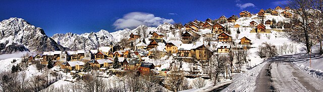
Юэ (Huez, Huez)

- коммуна во Франции
 Hiking in Юэ
Alpe d'Huez, situated in the French Alps, is well-known for its winter sports, but it offers excellent hiking opportunities during the summer months. Here are some highlights and tips for hiking in the Huez area:
Trails and Routes
-
Les Deux Alpes Trail: This trail offers stunning views of the glacier and surrounding mountains. It's a moderate hike that can be enjoyed by most fitness levels.
-
Lac Noir: A beautiful lake hike that takes you through meadows and offers scenic views. The trail can be challenging, but the crystal-clear waters of the lake are a rewarding sight.
-
Pic Blanc: There is a route that leads to Pic Blanc, which is one of the highest peaks in the region. The views from the summit are breathtaking and definitely worth the effort.
-
Alpe d'Huez – Villard-Reculas Trail: This is a more leisurely hike that connects the two villages and features panoramic views and charming landscapes.
Hiking Season
- Summer months (June to September) are ideal for hiking, with the best weather and fully accessible trails. Be mindful that conditions can change rapidly in the mountains, so always check the weather forecast before heading out.
Difficulty Levels
The trails vary in difficulty from easy family-friendly paths to challenging routes that may require a good level of fitness and hiking experience. It's important to choose a trail that matches your ability and fitness level.
Safety Tips
- Gear Up: Wear hiking boots and carry a good backpack with essential gear (water, snacks, first aid kit).
- Stay Hydrated: Always take enough water, as the altitude can be dehydrating.
- Navigation: Use maps or a GPS app, as trails can sometimes be poorly marked.
- Weather Awareness: Be prepared for changing weather conditions; temperatures can drop quickly at higher altitudes.
Other Activities
In addition to hiking, Alpe d'Huez offers mountain biking, paragliding, and via ferrata, making it a great destination for outdoor enthusiasts.
Conclusion
Hiking in Alpe d'Huez can be an unforgettable experience, offering spectacular Alpine scenery and a variety of trails suited to different skill levels. Make sure to plan accordingly, respect local wildlife, and enjoy your adventure in the mountains!
- Страна:

- Почтовый код: 38750
- Координаты: 45° 4' 57" N, 6° 3' 33" E


- GPS треки (wikiloc): [Ссылка]
- Площадь: 14.16 кв.км
- Население: 1335
- Веб сайт: http://www.alpedhuez-mairie.fr
- Википедия русская: wiki(ru)
- Википедия английская: wiki(en)
- Википедия национальная: wiki(fr)
- Хранилище Wikidata: Wikidata: Q1339530
- Катеория в википедии: [Ссылка]
- код Freebase: [/m/03g_6m3]
- код GeoNames: Альт: [6433213]
- номер SIREN: [213801913]
- код BNF: [152580098]
- код VIAF: Альт: [240539670]
- код муниципалитета INSEE: 38191
Граничит с регионами:
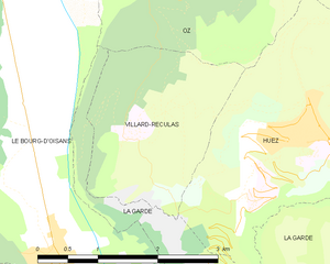
Виллар-Рекюла
- коммуна во Франции
Hiking in Виллар-Рекюла
Villard-Reculas is a charming alpine village located in the French Alps, part of the larger Alpe d'Huez ski area. It’s a fantastic destination for hiking enthusiasts, offering a variety of trails that cater to different levels of experience. Here are some key features and tips for hiking in Villard-Reculas:...
- Страна:
- Почтовый код: 38114
- Координаты: 45° 5' 32" N, 6° 1' 54" E
- GPS треки (wikiloc): [Ссылка]
- Площадь: 4.99 кв.км
- Население: 57
- Веб сайт: [Ссылка]
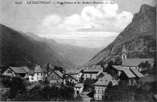

Оз (Изер)
- коммуна во Франции
Hiking in Оз (Изер)
Hiking in Oz, a charming alpine village located in the Isère department of France, offers exhilarating experiences amidst breathtaking scenery. Situated within the Grandes Rousses mountains in the French Alps, Oz is part of the Alpe d'Huez ski area, which transforms into a hiker's paradise during the summer months....
- Страна:
- Почтовый код: 38114
- Координаты: 45° 8' 27" N, 6° 3' 7" E
- GPS треки (wikiloc): [Ссылка]
- Площадь: 16.81 кв.км
- Население: 246
- Веб сайт: [Ссылка]


Ле-Френе-д'Уазан
- коммуна во Франции
Hiking in Ле-Френе-д'Уазан
Le Freney-d'Oisans is a charming village located in the Auvergne-Rhône-Alpes region of France, nestled in the French Alps. It's a fantastic location for hiking enthusiasts due to its stunning natural scenery, diverse trails, and proximity to other outdoor activities....
- Страна:
- Почтовый код: 38142
- Координаты: 45° 2' 41" N, 6° 7' 32" E
- GPS треки (wikiloc): [Ссылка]
- Площадь: 14.54 кв.км
- Население: 252
- Веб сайт: [Ссылка]


Ла-Гард
Hiking in Ла-Гард
La Garde is a charming commune located in the Isère department in southeastern France, nestled in the picturesque landscape of the French Alps. It's a great destination for hiking enthusiasts, offering a variety of trails that cater to different skill levels....
- Страна:
- Почтовый код: 38520
- Координаты: 45° 4' 8" N, 6° 2' 45" E
- GPS треки (wikiloc): [Ссылка]
- Высота над уровнем моря: 982 м m
- Площадь: 9.09 кв.км
- Население: 100
- Веб сайт: [Ссылка]


Ори
- коммуна во Франции
Hiking in Ори
Auris, located in the Isère department of the Auvergne-Rhône-Alpes region in France, offers stunning hiking opportunities, especially for those looking to explore the beautiful landscapes of the French Alps. Here’s a guide to hiking in Auris:...
- Страна:
- Почтовый код: 38142
- Координаты: 45° 2' 47" N, 6° 5' 12" E
- GPS треки (wikiloc): [Ссылка]
- Площадь: 11.21 кв.км
- Население: 201
- Веб сайт: [Ссылка]