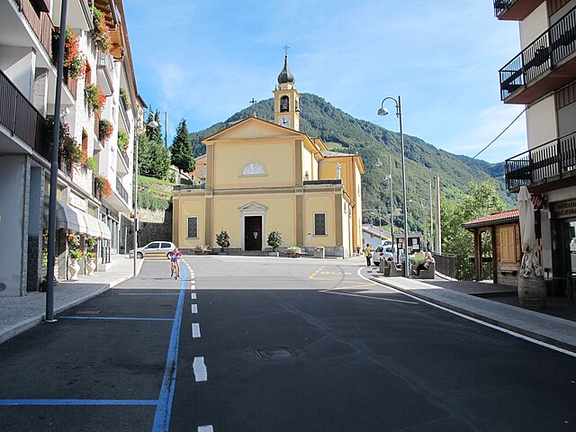
Интробьо (Introbio, Introbio)
.svg)
- коммуна Италии
 Hiking in Интробьо
Introbio is a picturesque village located in the Valtorta area of Italy, nestled in the Lombardy region. It serves as a gateway to some beautiful hiking trails and offers wonderful nature experiences for outdoor enthusiasts.
Key Points for Hiking in Introbio:
-
Diverse Trails: The area features a variety of trails suitable for all skill levels. Whether you’re a beginner or an experienced hiker, you can find routes that match your ability.
-
Scenic Views: The trails around Introbio often provide spectacular views of the surrounding mountains, valleys, and forests. The area is rich in natural beauty, with opportunities to see wildlife and various plant species.
-
Popular Routes:
- Sentiero dei Fiori (Flower Trail): A beautiful hike featuring a variety of wildflowers during the spring and summer months.
- Val Biandino: A stunning valley with several paths that lead to breathtaking lakes and mountain scenery.
- Monte Muggio: A hike that provides a more challenging ascent with rewarding panoramic views from the summit.
-
Access and Facilities: Introbio is accessible by car, and there are parking areas available. The village itself has basic facilities, such as restaurants and shops, where hikers can restock supplies or enjoy a meal after their hike.
-
Best Time to Hike: The ideal hiking season is typically from late spring to early autumn (May to October) when the weather is generally pleasant and trails are more accessible.
-
Preparation and Safety: As with any hiking adventure, it’s essential to prepare adequately. Carry water, snacks, suitable clothing, and a map or GPS device. Always check the weather forecast and be mindful of your fitness level.
-
Guided Tours: If you're new to hiking or the area, consider joining a guided group. Local guides can provide insight into the landscape, flora, and fauna, enhancing your hiking experience.
Remember to follow Leave No Trace principles to preserve the natural beauty of Introbio for future hikers. Enjoy your adventure!
- Страна:

- Почтовый код: 23815
- Телефонный код: 0341
- Код автомобильного номера: LC
- Координаты: 45° 58' 0" N, 9° 27' 0" E


- GPS треки (wikiloc): [Ссылка]
- Высота над уровнем моря: 586 м m
- Площадь: 26.03 кв.км
- Население: 1996
- Веб сайт: http://www.comune.introbio.lc.it/
- Википедия русская: wiki(ru)
- Википедия английская: wiki(en)
- Википедия национальная: wiki(it)
- Хранилище Wikidata: Wikidata: Q42856
- Катеория в википедии: [Ссылка]
- код Freebase: [/m/0gr3xt]
- код GeoNames: Альт: [6542107]
- код VIAF: Альт: [247865373]
- ID отношения в OpenStreetMap: [46631]
- UN/LOCODE: [ITZKU]
- код ISTAT: 097040
- кадастровый код Италии: E305
- LombardiaBeniCulturali toponym ID: 5000177
Граничит с регионами:


Вальторта
- коммуна Италии
Hiking in Вальторта
Valtorta is a beautiful area in Lombardy, Italy, particularly popular for hiking enthusiasts looking for stunning alpine landscapes. Nestled in the Bergamasque Alps, Valtorta offers a variety of trails that range in difficulty, making it a suitable destination for both beginners and experienced hikers....
- Страна:
- Почтовый код: 24010
- Телефонный код: 0345
- Код автомобильного номера: BG
- Координаты: 45° 58' 39" N, 9° 32' 5" E
- GPS треки (wikiloc): [Ссылка]
- Высота над уровнем моря: 935 м m
- Площадь: 30.9 кв.км
- Население: 270
- Веб сайт: [Ссылка]
Джерола-Альта
- коммуна Италии
Hiking in Джерола-Альта
Gerola Alta is a beautiful destination for hiking enthusiasts, located in the Lombardy region of Italy, specifically in the province of Sondrio. Known for its stunning mountain scenery, this area offers a variety of trails that cater to different skill levels, making it suitable for both novice and experienced hikers....
- Страна:
- Почтовый код: 23010
- Телефонный код: 0342
- Код автомобильного номера: SO
- Координаты: 46° 4' 0" N, 9° 34' 0" E
- GPS треки (wikiloc): [Ссылка]
- Высота над уровнем моря: 1050 м m
- Площадь: 37.43 кв.км
- Население: 174
- Веб сайт: [Ссылка]


Пастуро
- коммуна Италии
Hiking in Пастуро
Pasturo is a charming village located in the Lombardy region of Italy, nestled within the beautiful landscapes of the Valsassina valley. It's a great destination for hiking enthusiasts, offering various trails that showcase the natural beauty of the area, including stunning views of mountains, lush forests, and local wildlife....
- Страна:
- Почтовый код: 23818
- Телефонный код: 0341
- Код автомобильного номера: LC
- Координаты: 45° 57' 0" N, 9° 26' 0" E
- GPS треки (wikiloc): [Ссылка]
- Высота над уровнем моря: 641 м m
- Площадь: 21.78 кв.км
- Население: 1993
- Веб сайт: [Ссылка]
Прималуна
- коммуна Италии
Hiking in Прималуна
Primaluna is a picturesque village located in the heart of the Valsassina valley in Italy, nestled in the foothills of the Alps. It's a great destination for hiking enthusiasts due to its stunning landscapes, charming villages, and rich natural diversity. Here are some highlights for hiking in and around Primaluna:...
- Страна:
- Почтовый код: 23819
- Телефонный код: 0341
- Код автомобильного номера: LC
- Координаты: 45° 58' 0" N, 9° 26' 0" E
- GPS треки (wikiloc): [Ссылка]
- Высота над уровнем моря: 550 м m
- Площадь: 22.43 кв.км
- Население: 2258
- Веб сайт: [Ссылка]

Премана
- коммуна Италии
Hiking in Премана
Premana is a charming town located in the province of Lecco, in the Lombardy region of northern Italy. It's situated in the heart of the Alps, making it an ideal destination for hiking enthusiasts. The surrounding landscape is characterized by breathtaking mountains, lush valleys, and pristine nature, offering a variety of hiking trails suited for all levels of hikers....
- Страна:
- Почтовый код: 23834
- Телефонный код: 0341
- Код автомобильного номера: LC
- Координаты: 46° 3' 7" N, 9° 25' 23" E
- GPS треки (wikiloc): [Ссылка]
- Высота над уровнем моря: 1000 м m
- Площадь: 33.64 кв.км
- Население: 2262
- Веб сайт: [Ссылка]


Барцио
- коммуна Италии
Hiking in Барцио
Barzio is a charming town located in the Lombardy region of Italy, nestled in the heart of the Italian Alps. It is popular for its beautiful landscapes, abundant hiking trails, and outdoor activities. Here are some key points to consider when hiking in Barzio:...
- Страна:
- Почтовый код: 23816
- Телефонный код: 0341
- Код автомобильного номера: LC
- Координаты: 45° 57' 0" N, 9° 28' 0" E
- GPS треки (wikiloc): [Ссылка]
- Высота над уровнем моря: 769 м m
- Площадь: 21.35 кв.км
- Население: 1338
- Веб сайт: [Ссылка]