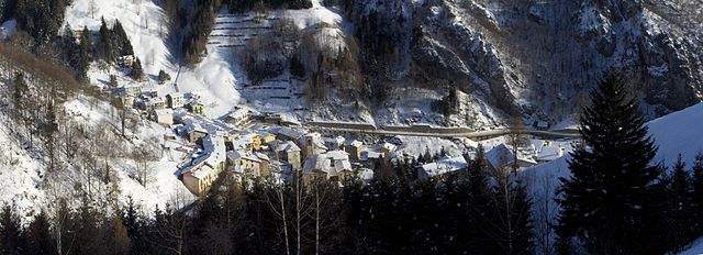
Джерола-Альта (Gerola Alta, Gerola Alta)
.svg)
- коммуна Италии
 Hiking in Джерола-Альта
Gerola Alta is a beautiful destination for hiking enthusiasts, located in the Lombardy region of Italy, specifically in the province of Sondrio. Known for its stunning mountain scenery, this area offers a variety of trails that cater to different skill levels, making it suitable for both novice and experienced hikers.
Hiking Trails
-
Sentiero dei Fiori: This scenic trail takes you through lush meadows and offers breathtaking views of the surrounding peaks. It’s particularly beautiful during the spring and summer months when the wildflowers are in bloom.
-
Val Gerola: Starting from Gerola Alta, this valley trail allows hikers to explore the natural beauty of the area, with opportunities to see waterfalls and local wildlife. The path is well-marked and provides several vantage points for photography.
-
Monte Bitto: For those looking for a challenge, hiking to the summit of Monte Bitto is highly rewarding. The ascent is steep but the panoramic views from the top are truly spectacular.
Tips for Hiking in Gerola Alta
-
Best Time to Visit: The hiking season typically runs from late spring through early autumn (May to October), with the best weather generally occurring in July and August.
-
Gear and Preparation: Make sure to wear proper hiking boots and carry essential gear such as a map, compass, water, snacks, and a first-aid kit. Sun protection is also important, as the altitude can mean stronger UV exposure.
-
Stay Hydrated: Always carry enough water, particularly on warmer days, as some trails may not have accessible water sources.
-
Respect Nature: Follow Leave No Trace principles by taking your trash with you and staying on marked paths to preserve the area’s natural beauty.
Local Culture and Attractions
Alongside hiking, Gerola Alta is rich in local culture, with traditional Alpine architecture and cuisine. Don’t miss the chance to enjoy local dishes, such as polenta and various cheese specialties, in one of the quaint restaurants or agriturismos.
Hiking in Gerola Alta can provide a fantastic experience for those looking to immerse themselves in nature, explore breathtaking landscapes, and enjoy the charm of the Italian Alps.
- Страна:

- Почтовый код: 23010
- Телефонный код: 0342
- Код автомобильного номера: SO
- Координаты: 46° 4' 0" N, 9° 34' 0" E


- GPS треки (wikiloc): [Ссылка]
- Высота над уровнем моря: 1050 м m
- Площадь: 37.43 кв.км
- Население: 174
- Веб сайт: http://www.comune.gerolaalta.so.it/
- Википедия русская: wiki(ru)
- Википедия английская: wiki(en)
- Википедия национальная: wiki(it)
- Хранилище Wikidata: Wikidata: Q40127
- Галерея изображений в википедии: [Ссылка]
- Катеория в википедии: [Ссылка]
- код Freebase: [/m/0gj32_]
- код GeoNames: Альт: [6541521]
- ID отношения в OpenStreetMap: [46707]
- код ISTAT: 014031
- кадастровый код Италии: D990
Граничит с регионами:


Кузио
- коммуна Италии
Hiking in Кузио
Cusio, located in the Lombardy region of Italy, is a picturesque area known for its stunning landscapes, including parts of Lake Orta and the surrounding mountains. This region offers a variety of hiking opportunities that cater to different skill levels, from leisurely walks along the shores of the lake to more challenging mountain trails....
- Страна:
- Почтовый код: 24010
- Телефонный код: 0345
- Код автомобильного номера: BG
- Координаты: 45° 59' 27" N, 9° 36' 9" E
- GPS треки (wikiloc): [Ссылка]
- Высота над уровнем моря: 1050 м m
- Площадь: 9.41 кв.км
- Население: 278
- Веб сайт: [Ссылка]

Орника
- коммуна Италии
Hiking in Орника
Ornica is a small village in the Lombardy region of northern Italy, situated in the Bergamasque Alps. It offers a beautiful natural setting for hikers and outdoor enthusiasts. Here are some highlights and important information regarding hiking in Ornica:...
- Страна:
- Почтовый код: 24010
- Телефонный код: 0345
- Код автомобильного номера: BG
- Координаты: 45° 59' 18" N, 9° 34' 45" E
- GPS треки (wikiloc): [Ссылка]
- Высота над уровнем моря: 922 м m
- Площадь: 15.1 кв.км
- Население: 152
- Веб сайт: [Ссылка]


Санта-Бриджида
- коммуна Италии
Hiking in Санта-Бриджида
Santa Brigida, located in the Lombardy region of northern Italy, is a wonderful destination for hiking enthusiasts. It is nestled in the Bergamo Alps, providing stunning landscapes, rich flora and fauna, and various trail options for different skill levels....
- Страна:
- Почтовый код: 24010
- Телефонный код: 0345
- Код автомобильного номера: BG
- Координаты: 45° 59' 0" N, 9° 37' 0" E
- GPS треки (wikiloc): [Ссылка]
- Высота над уровнем моря: 805 м m
- Площадь: 13.8 кв.км
- Население: 549
- Веб сайт: [Ссылка]


Вальторта
- коммуна Италии
Hiking in Вальторта
Valtorta is a beautiful area in Lombardy, Italy, particularly popular for hiking enthusiasts looking for stunning alpine landscapes. Nestled in the Bergamasque Alps, Valtorta offers a variety of trails that range in difficulty, making it a suitable destination for both beginners and experienced hikers....
- Страна:
- Почтовый код: 24010
- Телефонный код: 0345
- Код автомобильного номера: BG
- Координаты: 45° 58' 39" N, 9° 32' 5" E
- GPS треки (wikiloc): [Ссылка]
- Высота над уровнем моря: 935 м m
- Площадь: 30.9 кв.км
- Население: 270
- Веб сайт: [Ссылка]

Педезина
- коммуна Италии
Hiking in Педезина
Pedesina is a small and picturesque village located in the Valtellina region of northern Italy, nestled in the Alps. It offers stunning natural beauty and a variety of hiking opportunities for outdoor enthusiasts. Here are some highlights for hiking in and around Pedesina:...
- Страна:
- Почтовый код: 23010
- Телефонный код: 0342
- Код автомобильного номера: SO
- Координаты: 46° 5' 0" N, 9° 33' 0" E
- GPS треки (wikiloc): [Ссылка]
- Высота над уровнем моря: 1032 м m
- Площадь: 6.3 кв.км
- Население: 41
- Веб сайт: [Ссылка]
Бема
- коммуна Италии
Hiking in Бема
Bema, located in the Lombardy region of Italy, is a beautiful destination for hiking enthusiasts. Nestled in the mountainous area of the Valtellina valley, it offers stunning views, diverse landscapes, and rich flora and fauna. Here are some highlights and tips for hiking in Bema:...
- Страна:
- Почтовый код: 23010
- Телефонный код: 0342
- Код автомобильного номера: SO
- Координаты: 46° 7' 0" N, 9° 34' 0" E
- GPS треки (wikiloc): [Ссылка]
- Высота над уровнем моря: 800 м m
- Площадь: 19.22 кв.км
- Население: 116
- Веб сайт: [Ссылка]

Премана
- коммуна Италии
Hiking in Премана
Premana is a charming town located in the province of Lecco, in the Lombardy region of northern Italy. It's situated in the heart of the Alps, making it an ideal destination for hiking enthusiasts. The surrounding landscape is characterized by breathtaking mountains, lush valleys, and pristine nature, offering a variety of hiking trails suited for all levels of hikers....
- Страна:
- Почтовый код: 23834
- Телефонный код: 0341
- Код автомобильного номера: LC
- Координаты: 46° 3' 7" N, 9° 25' 23" E
- GPS треки (wikiloc): [Ссылка]
- Высота над уровнем моря: 1000 м m
- Площадь: 33.64 кв.км
- Население: 2262
- Веб сайт: [Ссылка]


Интробьо
- коммуна Италии
Hiking in Интробьо
Introbio is a picturesque village located in the Valtorta area of Italy, nestled in the Lombardy region. It serves as a gateway to some beautiful hiking trails and offers wonderful nature experiences for outdoor enthusiasts....
- Страна:
- Почтовый код: 23815
- Телефонный код: 0341
- Код автомобильного номера: LC
- Координаты: 45° 58' 0" N, 9° 27' 0" E
- GPS треки (wikiloc): [Ссылка]
- Высота над уровнем моря: 586 м m
- Площадь: 26.03 кв.км
- Население: 1996
- Веб сайт: [Ссылка]

Аверара
- коммуна Италии
Hiking in Аверара
Averara is a beautiful destination for hiking enthusiasts, nestled in the Bergamo Alps in the Lombardy region of Italy. This picturesque village offers a range of hiking trails suitable for various skill levels, set against the backdrop of stunning mountain scenery, lush forests, and vibrant flora....
- Страна:
- Почтовый код: 24010
- Телефонный код: 0345
- Код автомобильного номера: BG
- Координаты: 45° 59' 20" N, 9° 37' 53" E
- GPS треки (wikiloc): [Ссылка]
- Высота над уровнем моря: 650 м m
- Площадь: 10.69 кв.км
- Население: 178
- Веб сайт: [Ссылка]