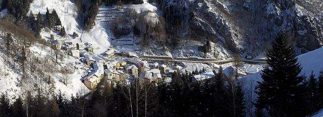
Вальторта (Valtorta, Lombardy, Valtorta)
.svg)
- коммуна Италии
 Hiking in Вальторта
Valtorta is a beautiful area in Lombardy, Italy, particularly popular for hiking enthusiasts looking for stunning alpine landscapes. Nestled in the Bergamasque Alps, Valtorta offers a variety of trails that range in difficulty, making it a suitable destination for both beginners and experienced hikers.
Key Features:
-
Scenic Trails: Valtorta features numerous well-marked hiking paths that take you through lush forests, picturesque meadows, and alongside clear streams. The views of the surrounding mountains are breathtaking, especially during the spring and autumn seasons.
-
Diverse Terrain: The area boasts a mix of terrain, from easy walks to more challenging ascents. You can choose flat routes that are suitable for families or opt for rigorous climbs that reward you with panoramic views.
-
Wildlife and Flora: While hiking in Valtorta, you might encounter various wildlife species, including deer, foxes, and a multitude of bird species. The region is also home to diverse plant life, with many wildflowers blooming during the warmer months.
-
Cultural Insights: Along the trails, you may come across several quaint villages, traditional farms, and old churches that reflect the local culture and history. These spots provide great opportunities for rest, refreshments, or simply enjoying the local landscape.
-
Seasonal Activities: In addition to summer hiking, Valtorta is known for winter sports, including skiing and snowshoeing. The landscape transforms beautifully during winter, offering a different experience for outdoor enthusiasts.
-
Accessibility: Valtorta is accessible from major cities like Milan and Bergamo, making it a convenient destination for day hikes or weekend trips.
Safety and Preparation:
- Trail Maps: Always carry a detailed map or use a GPS device, as some trails may not be well marked.
- Gear: Wear appropriate hiking footwear and carry essential gear, including water, snacks, a first-aid kit, and sun protection.
- Weather: Be mindful of the weather conditions, as they can change rapidly in the mountains. Check forecast updates before heading out.
Popular Hikes:
- Path of the Beech Trees: An easier walk through beautiful beech groves and offering stunning views of the surrounding peaks.
- Monte Verta: A more challenging hike, leading to a summit with sweeping views worth the effort.
Whether you are seeking a peaceful walk to enjoy nature or a rigorous adventure to test your hiking skills, Valtorta has something to offer all hiking enthusiasts.
- Страна:

- Почтовый код: 24010
- Телефонный код: 0345
- Код автомобильного номера: BG
- Координаты: 45° 58' 39" N, 9° 32' 5" E


- GPS треки (wikiloc): [Ссылка]
- Высота над уровнем моря: 935 м m
- Площадь: 30.9 кв.км
- Население: 270
- Веб сайт: http://www.comune.valtorta.bg.it
- Википедия русская: wiki(ru)
- Википедия английская: wiki(en)
- Википедия национальная: wiki(it)
- Хранилище Wikidata: Wikidata: Q101718
- Галерея изображений в википедии: [Ссылка]
- Катеория в википедии: [Ссылка]
- код Freebase: [/m/0gjfn6]
- код GeoNames: Альт: [6536162]
- код VIAF: Альт: [158446187]
- ID отношения в OpenStreetMap: [46600]
- код ISTAT: 016229
- кадастровый код Италии: L655
Граничит с регионами:


Кассильо
- коммуна Италии
Hiking in Кассильо
Cassiglio is a picturesque village located in the province of Bergamo, in the Lombardy region of Italy. It lies in the heart of the Italian Alps, making it a fantastic destination for hiking enthusiasts. Here are some key points about hiking in and around Cassiglio:...
- Страна:
- Почтовый код: 24010
- Телефонный код: 0345
- Код автомобильного номера: BG
- Координаты: 45° 58' 0" N, 9° 36' 44" E
- GPS треки (wikiloc): [Ссылка]
- Высота над уровнем моря: 602 м m
- Площадь: 13.68 кв.км
- Население: 110
- Веб сайт: [Ссылка]

Орника
- коммуна Италии
Hiking in Орника
Ornica is a small village in the Lombardy region of northern Italy, situated in the Bergamasque Alps. It offers a beautiful natural setting for hikers and outdoor enthusiasts. Here are some highlights and important information regarding hiking in Ornica:...
- Страна:
- Почтовый код: 24010
- Телефонный код: 0345
- Код автомобильного номера: BG
- Координаты: 45° 59' 18" N, 9° 34' 45" E
- GPS треки (wikiloc): [Ссылка]
- Высота над уровнем моря: 922 м m
- Площадь: 15.1 кв.км
- Население: 152
- Веб сайт: [Ссылка]


Ведезета
- коммуна Италии
Hiking in Ведезета
Vedeseta is a picturesque village located in the province of Bergamo in Lombardy, Italy, known for its stunning natural landscapes and hiking opportunities. The area is surrounded by the Italian Alps and offers various trails suitable for different skill levels, making it an attractive destination for hikers....
- Страна:
- Почтовый код: 24010
- Телефонный код: 0345
- Код автомобильного номера: BG
- Координаты: 45° 53' 27" N, 9° 32' 23" E
- GPS треки (wikiloc): [Ссылка]
- Высота над уровнем моря: 820 м m
- Площадь: 19.29 кв.км
- Население: 205
- Веб сайт: [Ссылка]
Джерола-Альта
- коммуна Италии
Hiking in Джерола-Альта
Gerola Alta is a beautiful destination for hiking enthusiasts, located in the Lombardy region of Italy, specifically in the province of Sondrio. Known for its stunning mountain scenery, this area offers a variety of trails that cater to different skill levels, making it suitable for both novice and experienced hikers....
- Страна:
- Почтовый код: 23010
- Телефонный код: 0342
- Код автомобильного номера: SO
- Координаты: 46° 4' 0" N, 9° 34' 0" E
- GPS треки (wikiloc): [Ссылка]
- Высота над уровнем моря: 1050 м m
- Площадь: 37.43 кв.км
- Население: 174
- Веб сайт: [Ссылка]


Барцио
- коммуна Италии
Hiking in Барцио
Barzio is a charming town located in the Lombardy region of Italy, nestled in the heart of the Italian Alps. It is popular for its beautiful landscapes, abundant hiking trails, and outdoor activities. Here are some key points to consider when hiking in Barzio:...
- Страна:
- Почтовый код: 23816
- Телефонный код: 0341
- Код автомобильного номера: LC
- Координаты: 45° 57' 0" N, 9° 28' 0" E
- GPS треки (wikiloc): [Ссылка]
- Высота над уровнем моря: 769 м m
- Площадь: 21.35 кв.км
- Население: 1338
- Веб сайт: [Ссылка]


Интробьо
- коммуна Италии
Hiking in Интробьо
Introbio is a picturesque village located in the Valtorta area of Italy, nestled in the Lombardy region. It serves as a gateway to some beautiful hiking trails and offers wonderful nature experiences for outdoor enthusiasts....
- Страна:
- Почтовый код: 23815
- Телефонный код: 0341
- Код автомобильного номера: LC
- Координаты: 45° 58' 0" N, 9° 27' 0" E
- GPS треки (wikiloc): [Ссылка]
- Высота над уровнем моря: 586 м m
- Площадь: 26.03 кв.км
- Население: 1996
- Веб сайт: [Ссылка]