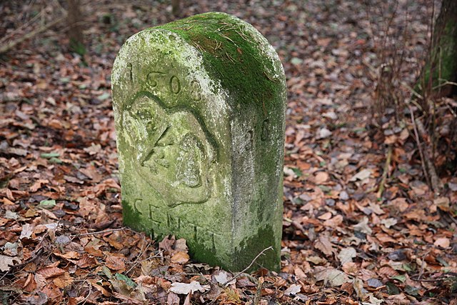
Лихтенфельс (Lichtenfels, Landkreis Lichtenfels)

- Район в Германии
 Hiking in Лихтенфельс
Lichtenfels is a district in Bavaria, Germany, known for its picturesque landscapes and scenic hiking trails. Nestled in the heart of the Franconian region, it offers a variety of hiking opportunities suitable for different skill levels and preferences. Here are some key points about hiking in Lichtenfels:
1.
- Diverse Routes: The district features diverse hiking routes that range from easy, leisurely walks to more challenging hikes for experienced trekkers.
- Natural Beauty: Hikers can enjoy beautiful forests, rolling hills, and scenic valleys. The landscape is characterized by its lush greenery and charming Franconian villages.
2.
- Giechburg: This hill offers trails with stunning views over the surrounding countryside. The Giechburg Castle ruins are a popular destination for hikers, providing a historical element to the hike.
- Fränkische Schweiz (Franconian Switzerland): Lichtenfels is close to this famous hiking region, known for its striking limestone formations, caves, and traditional Franconian villages.
3.
- The trails are well-marked with signage in accordance with local hiking standards, making navigation easier for hikers. Look for the standard color-coded markers for different trail types.
4.
- Spring and Autumn: These seasons are particularly beautiful for hiking, with blooming flora in spring and vibrant fall colors.
- Winter Hiking: Some trails may be suitable for winter hiking, but ensure you check the conditions before heading out and be prepared for potential snow or icy paths.
5.
- Footwear: Good hiking boots are recommended due to varying terrain.
- Supplies: Carry enough water, snacks, and a basic first-aid kit. It's also helpful to have a map or a hiking app on your phone for navigation.
6.
- There are various small towns and villages where hikers can rest, enjoy a meal, or stay overnight. Local eateries often serve traditional Bavarian cuisine, providing a perfect way to recharge after a long day of hiking.
7.
- For those unfamiliar with the area, consider joining a guided tour which can offer insights into the local wildlife, history, and geology.
Whether you are an experienced hiker or just starting out, Lichtenfels offers a wealth of opportunities to explore the great outdoors and enjoy the beauty of the Bavarian countryside. Remember always to respect nature and follow local guidelines while hiking.
- Страна:

- Столица: Лихтенфельс
- Код автомобильного номера: STE; LIF
- Координаты: 50° 6' 36" N, 11° 7' 12" E


- GPS треки (wikiloc): [Ссылка]
- Высота над уровнем моря: 422 м m
- Площадь: 552.00 кв.км
- Население: 65602
- Веб сайт: http://www.landkreis-lichtenfels.de/
- Википедия русская: wiki(ru)
- Википедия английская: wiki(en)
- Википедия национальная: wiki(de)
- Хранилище Wikidata: Wikidata: Q10442
- Катеория в википедии: [Ссылка]
- Карты в википедии: [Ссылка]
- код Freebase: [/m/020cj0]
- код GeoNames: Альт: [3220852]
- код VIAF: Альт: [126749191]
- ID отношения в OpenStreetMap: [62515]
- код GND: Альт: [4099608-6]
- идентификатор местоположения ArchINFORM: [3375]
- код LCNAF: Альт: [n86018252]
- код TGN: [7077100]
- код Historical Gazetteer: [adm_139478]
- Bavarikon ID: [ODB_A00002130]
- код NUTS: [DE24C]
- код BabelNet: [03066066n]
- код района Германии: 09478
Включает регионы:

Neuensorger Forst
Hiking in Neuensorger Forst
Neuensorger Forst, located in Germany, is a forested area that offers a variety of hiking opportunities. Here are some key points to consider when planning a hike in Neuensorger Forst:...
- Страна:
- Координаты: 50° 11' 0" N, 11° 6' 0" E
- GPS треки (wikiloc): [Ссылка]

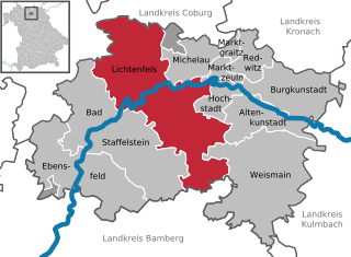
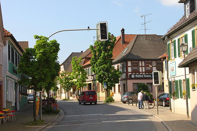
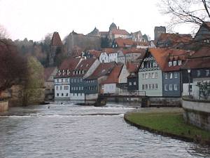
Лихтенфельс
- город в Баварии
Hiking in Лихтенфельс
Lichtenfels is a beautiful town located in Bavaria, Germany, and offers a variety of hiking opportunities that showcase the region's scenic landscapes, forests, and cultural landmarks. Here’s an overview of what you can expect when hiking in and around Lichtenfels:...
- Страна:
- Почтовый код: 96215
- Телефонный код: 09571
- Код автомобильного номера: LIF
- Координаты: 50° 8' 0" N, 11° 2' 0" E
- GPS треки (wikiloc): [Ссылка]
- Высота над уровнем моря: 271 м m
- Площадь: 122.27 кв.км
- Население: 20080
- Веб сайт: [Ссылка]


Бургунштадт
Hiking in Бургунштадт
Burgkunstadt, located in Bavaria, Germany, offers a variety of hiking opportunities for outdoor enthusiasts. The landscape in this region is characterized by rolling hills, lush forests, and scenic views of the surrounding countryside, making it an excellent destination for both casual walkers and dedicated hikers....
- Страна:
- Почтовый код: 96224
- Телефонный код: 09572
- Код автомобильного номера: LIF
- Координаты: 50° 7' 0" N, 11° 15' 0" E
- GPS треки (wikiloc): [Ссылка]
- Высота над уровнем моря: 304 м m
- Площадь: 40.59 кв.км
- Население: 6384
- Веб сайт: [Ссылка]


Альтенкунштадт
Hiking in Альтенкунштадт
Altenkunstadt is a quaint town located in Bavaria, Germany, surrounded by picturesque landscapes that make it a great destination for hiking enthusiasts. The region features a variety of trails that cater to different experience levels, from leisurely walks to more challenging hikes....
- Страна:
- Почтовый код: 96264
- Телефонный код: 09572
- Код автомобильного номера: LIF
- Координаты: 50° 7' 0" N, 11° 15' 0" E
- GPS треки (wikiloc): [Ссылка]
- Высота над уровнем моря: 292 м m
- Площадь: 32.91 кв.км
- Население: 5380
- Веб сайт: [Ссылка]


Вайсмайн
Hiking in Вайсмайн
Weismain is a charming town located in Bavaria, Germany, surrounded by stunning landscapes that are ideal for hiking enthusiasts. The region around Weismain is characterized by its picturesque hills, lush forests, and scenic valleys, making it a great destination for outdoor activities....
- Страна:
- Почтовый код: 96260
- Телефонный код: 09576; 09575; 09504; 09220
- Код автомобильного номера: LIF
- Координаты: 50° 4' 0" N, 11° 13' 0" E
- GPS треки (wikiloc): [Ссылка]
- Высота над уровнем моря: 316 м m
- Площадь: 90.14 кв.км
- Население: 4675
- Веб сайт: [Ссылка]


Марктграйц
Hiking in Марктграйц
Marktgraitz is a charming village located in Bavaria, Germany, and offers pleasant hiking opportunities amidst beautiful rural landscapes and natural scenery. The region is characterized by rolling hills, forests, and fields, making it a great destination for outdoor enthusiasts....
- Страна:
- Почтовый код: 96257
- Телефонный код: 09574
- Код автомобильного номера: LIF
- Координаты: 50° 10' 0" N, 11° 11' 0" E
- GPS треки (wikiloc): [Ссылка]
- Высота над уровнем моря: 292 м m
- Площадь: 3.75 кв.км
- Население: 1251
- Веб сайт: [Ссылка]

Эбенсфельд
Hiking in Эбенсфельд
Ebensfeld, located in Bavaria, Germany, provides a charming backdrop for hiking enthusiasts. The region is characterized by its picturesque landscapes, including rolling hills, forests, and a variety of trails suitable for different skill levels....
- Страна:
- Почтовый код: 96250
- Телефонный код: 09533; 09547; 09573
- Код автомобильного номера: LIF
- Координаты: 50° 4' 0" N, 10° 56' 59" E
- GPS треки (wikiloc): [Ссылка]
- Высота над уровнем моря: 255 м m
- Площадь: 68.72 кв.км
- Население: 5281
- Веб сайт: [Ссылка]

Хохштадт-на-Майне
Hiking in Хохштадт-на-Майне
Hochstadt am Main is a charming village located in Bavaria, Germany, and is nestled along the Main River. It's a great destination for hiking enthusiasts due to its scenic landscapes, rich history, and the serene beauty of the surrounding countryside. Here are some highlights and tips for hiking in the area:...
- Страна:
- Почтовый код: 96272
- Телефонный код: 09574
- Код автомобильного номера: LIF
- Координаты: 50° 9' 0" N, 11° 10' 16" E
- GPS треки (wikiloc): [Ссылка]
- Высота над уровнем моря: 283 м m
- Площадь: 13.78 кв.км
- Население: 1679
- Веб сайт: [Ссылка]

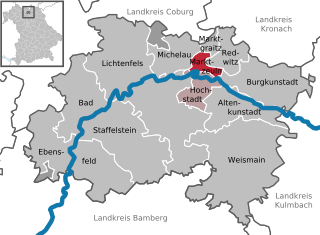
Марктцойльн
Hiking in Марктцойльн
Marktzeuln, located in Bavaria, Germany, offers beautiful landscapes and a variety of hiking trails suitable for different skill levels. The region is characterized by rolling hills, lush forests, and scenic views of the surrounding countryside, making it an attractive destination for outdoor enthusiasts....
- Страна:
- Почтовый код: 96275
- Телефонный код: 09574
- Код автомобильного номера: LIF
- Координаты: 50° 10' 0" N, 11° 11' 0" E
- GPS треки (wikiloc): [Ссылка]
- Высота над уровнем моря: 292 м m
- Площадь: 6.86 кв.км
- Население: 1539
- Веб сайт: [Ссылка]


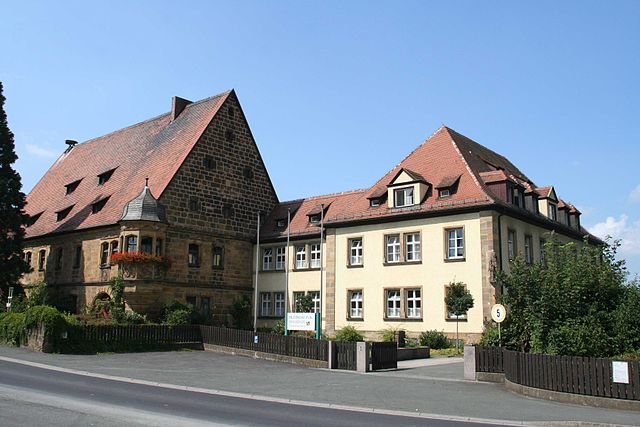
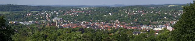
Бад-Штаффельштайн
Hiking in Бад-Штаффельштайн
Bad Staffelstein, located in the Upper Franconia region of Bavaria, Germany, is a wonderful destination for hiking enthusiasts. The area is known for its scenic landscapes, rich history, and a variety of well-marked hiking trails that cater to different skill levels. Here are some highlights and tips for hiking in Bad Staffelstein:...
- Страна:
- Почтовый код: 96231
- Телефонный код: 09573
- Координаты: 50° 6' 0" N, 10° 58' 0" E
- GPS треки (wikiloc): [Ссылка]
- Высота над уровнем моря: 274 м m
- Площадь: 99.39 кв.км
- Население: 10231
- Веб сайт: [Ссылка]


Михелау
Hiking in Михелау
Michelau in Oberfranken is a charming location for hiking enthusiasts. Nestled in the scenic Bavarian region of Franconia, it offers beautiful landscapes, lush greenery, and well-marked trails that cater to various skill levels....
- Страна:
- Почтовый код: 96247
- Телефонный код: 09574; 09571
- Код автомобильного номера: LIF
- Координаты: 50° 10' 0" N, 11° 7' 0" E
- GPS треки (wikiloc): [Ссылка]
- Высота над уровнем моря: 266 м m
- Площадь: 19.36 кв.км
- Население: 6336
- Веб сайт: [Ссылка]


Редвиц-ан-дер-Родах
Hiking in Редвиц-ан-дер-Родах
Redwitz an der Rodach is located in the Franconian region of Bavaria, Germany, and offers picturesque landscapes and a variety of hiking opportunities. The area is characterized by rolling hills, lush forests, and scenic views, making it an ideal destination for both casual walkers and experienced hikers....
- Страна:
- Почтовый код: 96257
- Телефонный код: 09574
- Код автомобильного номера: LIF
- Координаты: 50° 10' 24" N, 11° 12' 30" E
- GPS треки (wikiloc): [Ссылка]
- Высота над уровнем моря: 288 м m
- Площадь: 14.66 кв.км
- Население: 3364
- Веб сайт: [Ссылка]
Breitengüßbacher Forst
Hiking in Breitengüßbacher Forst
Breitengüßbacher Forst, located in Bavaria, Germany, offers a serene and picturesque environment for hiking enthusiasts. Known for its dense forests, rolling hills, and diverse flora and fauna, this area is ideal for both casual walkers and seasoned hikers....
- Страна:
- Координаты: 50° 2' 0" N, 10° 55' 0" E
- GPS треки (wikiloc): [Ссылка]
Граничит с регионами:
Кронах
- район Баварии
Hiking in Кронах
Kronach, located in Bavaria, Germany, is an excellent destination for hiking enthusiasts. The district is characterized by its beautiful landscapes, rich history, and diverse trails suitable for all levels of hikers. Here are some highlights regarding hiking in Kronach:...
- Страна:
- Столица: Кронах
- Код автомобильного номера: SAN; KC
- Координаты: 50° 19' 48" N, 11° 22' 12" E
- GPS треки (wikiloc): [Ссылка]
- Высота над уровнем моря: 412 м m
- Площадь: 651.00 кв.км
- Население: 75353
- Веб сайт: [Ссылка]

Кульмбах
- район Баварии
Hiking in Кульмбах
Kulmbach district, located in Bavaria, Germany, offers a variety of hiking opportunities that showcase the region’s scenic beauty, rich history, and diverse landscapes. Here are some highlights and tips for hiking in Kulmbach:...
- Страна:
- Столица: Кульмбах
- Код автомобильного номера: SAN; KU; EBS
- Координаты: 50° 5' 12" N, 11° 23' 50" E
- GPS треки (wikiloc): [Ссылка]
- Высота над уровнем моря: 391 м m
- Площадь: 656.00 кв.км
- Население: 73055
- Веб сайт: [Ссылка]

Байройт
- район Баварии
Hiking in Байройт
Bayreuth, located in the northern part of Bavaria, Germany, offers a diverse range of hiking opportunities set against a backdrop of beautiful landscapes, forests, and cultural sites. The region is known for its rich history, stunning scenery, and well-marked trails suitable for hikers of all levels....
- Страна:
- Столица: Байройт
- Код автомобильного номера: PEG; MÜB; KEM; ESB; EBS; BT
- Координаты: 49° 55' 12" N, 11° 30' 0" E
- GPS треки (wikiloc): [Ссылка]
- Высота над уровнем моря: 507 м m
- Площадь: 1273.00 кв.км
- Население: 96772
- Веб сайт: [Ссылка]
Кобург
- район в Баварии, Германия
Hiking in Кобург
Coburg district, located in Bavaria, Germany, offers a variety of hiking opportunities for outdoor enthusiasts. The region is characterized by beautiful landscapes, including rolling hills, woodlands, and scenic views that make for enjoyable hiking experiences....
- Страна:
- Столица: Кобург
- Код автомобильного номера: NEC; CO
- Координаты: 50° 16' 0" N, 10° 55' 0" E
- GPS треки (wikiloc): [Ссылка]
- Высота над уровнем моря: 306 м m
- Площадь: 592.00 кв.км
- Население: 82033
- Веб сайт: [Ссылка]
Бамберг
Hiking in Бамберг
Bamberg district, located in Bavaria, Germany, offers a variety of scenic hiking opportunities amidst its charming landscapes, historical sites, and cultural attractions. Here’s an overview of what you can expect when hiking in the region:...
- Страна:
- Столица: Бамберг
- Код автомобильного номера: BA
- Координаты: 49° 49' 48" N, 10° 49' 48" E
- GPS треки (wikiloc): [Ссылка]
- Высота над уровнем моря: 275 м m
- Площадь: 1168.00 кв.км
- Население: 119829
- Веб сайт: [Ссылка]