Л’Альбенк (L'Albenc, L'Albenc)

- коммуна во Франции
 Hiking in Л’Альбенк
L'Albenc is a charming village located in the Auvergne-Rhône-Alpes region of southeastern France. The area surrounding L'Albenc offers a range of hiking opportunities suited for various skill levels, with stunning views of the surrounding mountains and valleys.
Hiking Highlights:
-
Scenic Trails: The region boasts trails that wind through picturesque landscapes, including forests, meadows, and rocky terrains. The trails typically feature panoramic views of the Vercors and Chartreuse mountains.
-
Diverse Wildlife: As you hike, keep an eye out for the diverse fauna and flora that thrive in the area. The natural environment is home to various bird species, wildflowers, and small mammals.
-
Routes for All Levels: There are multiple trails catering to different experience levels—from easy walks suitable for families to more challenging hikes for seasoned trekkers.
-
Cultural Aspects: Some trails may lead you past historical landmarks, local farms, and quaint villages, giving you a glimpse into the rural life and culture of the Auvergne-Rhône-Alpes region.
-
Seasonal Considerations: The best time for hiking in and around L'Albenc is typically from late spring to early fall, when the weather is milder, and the trails are more accessible. However, certain trails may remain open in winter for snowshoeing or winter hikes—just ensure you are well-prepared for changing conditions.
Tips for Hiking in L'Albenc:
- Stay Hydrated: Always carry enough water, especially on longer hikes.
- Appropriate Gear: Wear sturdy hiking boots and weather-appropriate clothing, as conditions can change rapidly in mountainous areas.
- Trail Maps: Consider carrying a detailed map or using a hiking app, as some trails may not be well-marked.
- Local Regulations: Be mindful of local guidelines and regulations regarding trail access and wildlife protection.
Whether you're looking to immerse yourself in nature for a day or tackle a multi-day trek, L'Albenc and its surroundings provide a wonderful setting for hiking enthusiasts. Enjoy your adventure!
- Страна:

- Почтовый код: 38470
- Координаты: 45° 13' 30" N, 5° 26' 26" E


- GPS треки (wikiloc): [Ссылка]
- Площадь: 9.86 кв.км
- Население: 1170
- Веб сайт: http://albenc.sud-gresivaudan.org
- Википедия русская: wiki(ru)
- Википедия английская: wiki(en)
- Википедия национальная: wiki(fr)
- Хранилище Wikidata: Wikidata: Q1009045
- Катеория в википедии: [Ссылка]
- код Freebase: [/m/03g_7nt]
- код GeoNames: Альт: [6614323]
- номер SIREN: [213800048]
- код BNF: [15257834f]
- код VIAF: Альт: [233889905]
- код тезауруса PACTOLS: [pcrtpTzwiH4bbu]
- WOEID: [596379]
- код муниципалитета INSEE: 38004
Граничит с регионами:


Сен-Жерве
Hiking in Сен-Жерве
Saint-Gervais is a beautiful commune located in the Isère department of the Auvergne-Rhône-Alpes region in southeastern France. It offers stunning landscapes, diverse trails, and a range of activities for outdoor enthusiasts, making it a fantastic destination for hikers....
- Страна:
- Почтовый код: 38470
- Координаты: 45° 12' 6" N, 5° 28' 55" E
- GPS треки (wikiloc): [Ссылка]
- Площадь: 13.15 кв.км
- Население: 567
- Веб сайт: [Ссылка]


Ла-Ривьер
Hiking in Ла-Ривьер
La Rivière is a beautiful commune located in the Isère department of the Auvergne-Rhône-Alpes region in southeastern France. The area is characterized by stunning natural landscapes, mountains, and rivers, making it an excellent destination for hiking enthusiasts....
- Страна:
- Почтовый код: 38210
- Координаты: 45° 14' 13" N, 5° 30' 29" E
- GPS треки (wikiloc): [Ссылка]
- Площадь: 18.45 кв.км
- Население: 770
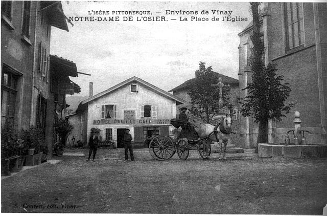
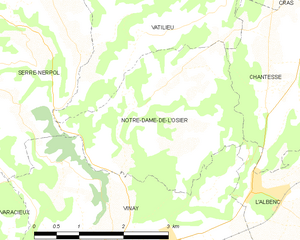
Нотр-Дам-де-л'Озье
- коммуна во Франции
Hiking in Нотр-Дам-де-л'Озье
Notre-Dame-de-l'Osier, located in the Isère department of France, is a charming village surrounded by stunning natural landscapes, making it an excellent destination for hiking enthusiasts. Here are some highlights:...
- Страна:
- Почтовый код: 38470
- Координаты: 45° 14' 18" N, 5° 24' 19" E
- GPS треки (wikiloc): [Ссылка]
- Площадь: 8.38 кв.км
- Население: 478
- Веб сайт: [Ссылка]


Вине
- коммуна во Франции
Hiking in Вине
Vinay, located in the Isère department of the Auvergne-Rhône-Alpes region in France, is a charming village surrounded by beautiful natural landscapes, making it a great spot for hiking enthusiasts. Here are a few key points to consider when hiking in and around Vinay:...
- Страна:
- Почтовый код: 38470
- Координаты: 45° 12' 36" N, 5° 24' 13" E
- GPS треки (wikiloc): [Ссылка]
- Площадь: 16.01 кв.км
- Население: 4200
- Веб сайт: [Ссылка]

Шантесс
- коммуна во Франции
Hiking in Шантесс
Chantesse, located in the picturesque region of France, offers a variety of hiking opportunities for both beginners and seasoned trekkers. It's nestled in the Vercors massif, which is known for its stunning landscapes, limestone cliffs, and diverse flora and fauna....
- Страна:
- Почтовый код: 38470
- Координаты: 45° 14' 34" N, 5° 26' 40" E
- GPS треки (wikiloc): [Ссылка]
- Площадь: 5.83 кв.км
- Население: 320
- Веб сайт: [Ссылка]


Ровон
- коммуна во Франции
Hiking in Ровон
Rovon is not a widely recognized hiking destination, but if you're referring to a specific location, I can provide general advice and tips for hiking in various terrains and regions. If Rovon is a local area or trail, it may have features typical of outdoor hiking locales....
- Страна:
- Почтовый код: 38470
- Координаты: 45° 12' 9" N, 5° 27' 41" E
- GPS треки (wikiloc): [Ссылка]
- Площадь: 11.82 кв.км
- Население: 609
- Веб сайт: [Ссылка]

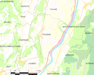
Польенас
- коммуна во Франции
Hiking in Польенас
Poliénas, a charming commune in the Isère department of southeastern France, is well situated for outdoor activities, including hiking. Nestled near the foothills of the Alps, the area offers stunning natural landscapes, diverse terrain, and numerous trails suitable for various skill levels....
- Страна:
- Почтовый код: 38210
- Координаты: 45° 14' 56" N, 5° 28' 17" E
- GPS треки (wikiloc): [Ссылка]
- Площадь: 14.03 кв.км
- Население: 1150
- Веб сайт: [Ссылка]