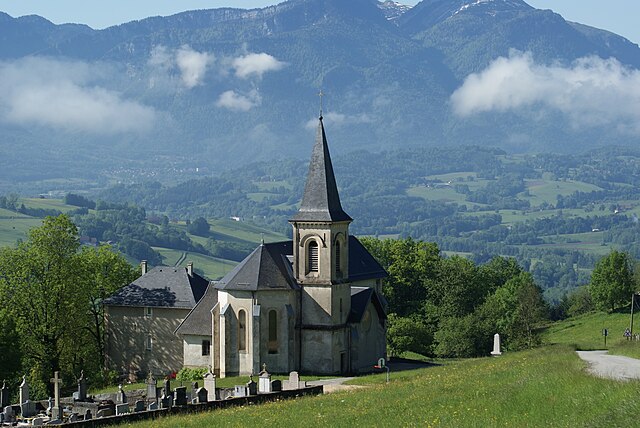
La Bauche (La Bauche)

- коммуна во Франции
 Hiking in La Bauche
La Bauche, located in the Auvergne-Rhône-Alpes region of France, offers a variety of hiking opportunities that showcase the beautiful landscapes and unique geology of the area. While it may not be as well-known as some of the larger alpine areas, it has its own charm.
Hiking Trails and Areas:
-
Les Chemins de randonnées: La Bauche is surrounded by several marked hiking trails. You can explore scenic routes that take you through lush forests, rolling hills, and picturesque countryside.
-
Lake and River Views: Depending on your selected trails, you may find paths that lead you along rivers or lakesides, providing stunning views of the water and surrounding landscapes.
-
Nearby Natural Parks: There are also opportunities to hike in nearby natural parks, such as the Chartreuse Massif or the Bauges Regional Natural Park, which offer more challenging hikes and spectacular views of the Alps.
Difficulty Levels:
Hiking trails around La Bauche vary in difficulty, so there are options suitable for families and beginners, as well as more challenging routes for experienced hikers. Always check trail markers and maps to match your hiking experience with the trail difficulty.
Best Time to Visit:
The best times for hiking in the La Bauche area are typically from late spring to early autumn (May to October) when the weather is pleasant, and the scenery is at its most vibrant.
Preparation and Tips:
-
Map and Navigation: Always carry a detailed map or a GPS device, as some trails may not be well-marked.
-
Weather: Be prepared for changing weather conditions, especially in mountainous areas.
-
Safety: Ensure you have adequate supplies, including water, snacks, and a first-aid kit.
-
Footwear: Wear appropriate hiking shoes or boots to ensure good grip and comfort during your hike.
-
Local Regulations: Be mindful of local regulations regarding wildlife and plant preservation, and stick to designated trails to protect the natural environment.
Conclusion:
La Bauche is a wonderful destination for those looking to explore the outdoors in a less commercialized setting. Whether you're seeking a leisurely stroll or a day-long hike, the area provides diverse experiences that cater to all levels of hikers. Always plan ahead, respect nature, and enjoy your trekking experience!
- Страна:

- Почтовый код: 73360
- Координаты: 45° 28' 57" N, 5° 45' 54" E


- GPS треки (wikiloc): [Ссылка]
- Площадь: 6.58 кв.км
- Население: 512
- Википедия английская: wiki(en)
- Википедия национальная: wiki(fr)
- Хранилище Wikidata: Wikidata: Q764688
- Катеория в википедии: [Ссылка]
- код Freebase: [/m/03qlly1]
- код GeoNames: Альт: [6614534]
- номер SIREN: [217300334]
- код BNF: [15273969t]
- код Pleiades: [167669]
- код муниципалитета INSEE: 73033
Граничит с регионами:


Saint-Thibaud-de-Couz
- коммуна во Франции
Hiking in Saint-Thibaud-de-Couz
Saint-Thibaud-de-Couz is a charming commune located in the Savoie department of the Auvergne-Rhône-Alpes region in southeastern France. It is surrounded by the breathtaking natural beauty of the Alps, making it an excellent destination for hiking enthusiasts. Here are some highlights to consider when planning a hiking adventure in and around Saint-Thibaud-de-Couz:...
- Страна:
- Почтовый код: 73160
- Координаты: 45° 30' 4" N, 5° 50' 40" E
- GPS треки (wikiloc): [Ссылка]
- Площадь: 24.17 кв.км
- Население: 1041

Saint-Franc
- коммуна во Франции
Hiking in Saint-Franc
Saint-Franc, often referred to in the context of Saint-François, is a scenic region located in Guadeloupe, known for its beautiful landscapes and diverse hiking opportunities. When hiking in this area, you can expect a mix of coastal and inland trails offering stunning views, lush vegetation, and unique wildlife....
- Страна:
- Почтовый код: 73360
- Координаты: 45° 29' 29" N, 5° 44' 46" E
- GPS треки (wikiloc): [Ссылка]
- Площадь: 7.25 кв.км
- Население: 166


Attignat-Oncin
- коммуна во Франции
Hiking in Attignat-Oncin
Attignat-Oncin is a lovely commune in the Auvergne-Rhône-Alpes region of France, nestled at the foothills of the French Alps. It offers a range of hiking opportunities that cater to various skill levels, making it an ideal destination for nature lovers and outdoor enthusiasts....
- Страна:
- Почтовый код: 73610
- Координаты: 45° 30' 30" N, 5° 46' 33" E
- GPS треки (wikiloc): [Ссылка]
- Площадь: 18.46 кв.км
- Население: 527


Saint-Jean-de-Couz
- коммуна во Франции
Hiking in Saint-Jean-de-Couz
Saint-Jean-de-Couz is a charming commune located in the Savoie department of the Auvergne-Rhône-Alpes region in southeastern France. It's nestled at the foot of the Alps, making it an excellent destination for hiking enthusiasts, particularly those who are looking to explore the beautiful landscapes of the French Alps....
- Страна:
- Почтовый код: 73160
- Координаты: 45° 28' 2" N, 5° 49' 6" E
- GPS треки (wikiloc): [Ссылка]
- Площадь: 7.71 кв.км
- Население: 286
Saint-Pierre-de-Genebroz
- коммуна во Франции
Hiking in Saint-Pierre-de-Genebroz
Saint-Pierre-de-Genebroz is a charming commune located in the Auvergne-Rhône-Alpes region of France. It is surrounded by picturesque landscapes, making it a great spot for hiking enthusiasts. Here are some insights into hiking in and around Saint-Pierre-de-Genebroz:...
- Страна:
- Почтовый код: 73360
- Координаты: 45° 27' 10" N, 5° 45' 14" E
- GPS треки (wikiloc): [Ссылка]
- Площадь: 6.14 кв.км
- Население: 343