La Bretenière (La Bretenière)

- коммуна во Франции
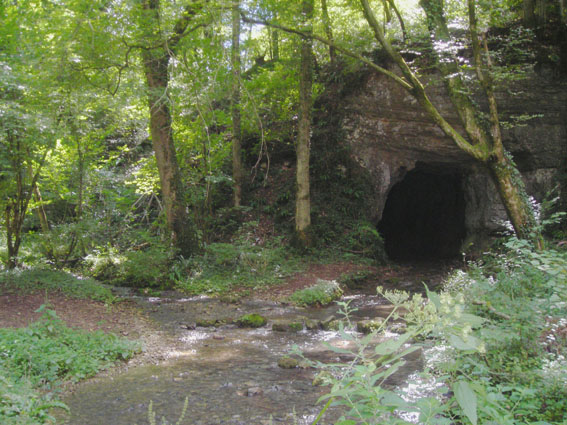
 Hiking in La Bretenière
La Bretenière, located in the Doubs department of France, offers a picturesque setting for hiking enthusiasts. The area is characterized by its beautiful natural landscapes, including rolling hills, lush forests, and meandering rivers, making it a great spot for both casual walkers and more experienced hikers.
Hiking Trails
-
Local Routes: There are several marked trails around La Bretenière that cater to different skill levels. These paths often feature scenic views and opportunities to spot local wildlife.
-
GR and PR Trails: The Grande Randonnée (GR) and Petite Randonnée (PR) trails provide longer hiking experiences that can take you through the surrounding countryside and connect you to other nearby villages and natural attractions.
-
Nature Reserves: Some trails may pass through local nature reserves, where you can enjoy the biodiversity of the region and possibly encounter unique flora and fauna.
Best Times to Hike
- Spring and Fall: These seasons offer mild weather and beautiful scenery, with blooming flowers in spring and stunning autumn foliage.
- Summer: While generally warm, it’s essential to carry enough water and wear sun protection, as some trails might expose you to the sun.
Preparation and Tips
- Gear: Wear appropriate hiking boots and consider layers to accommodate changing weather conditions.
- Navigation: A map or GPS device might be helpful, as some trails may not always be clearly marked.
- Local Advice: Checking in with local tourism offices can provide you with updated trail information and safety tips.
- Wildlife Considerations: Respect the natural environment and local wildlife; keep a safe distance from animals and take your litter with you.
Amenities
- Accommodation: For those planning an extended stay, local inns or campsites can provide overnight options.
- Food and Drink: Small cafes and restaurants in the nearby villages offer local cuisine, so you can refuel after a day of exploring.
Overall, hiking in La Bretenière can be a rewarding experience filled with natural beauty and tranquility.
- Страна:

- Почтовый код: 25640
- Координаты: 47° 22' 52" N, 6° 16' 28" E


- GPS треки (wikiloc): [Ссылка]
- Площадь: 4.16 кв.км
- Население: 70
- Википедия английская: wiki(en)
- Википедия национальная: wiki(fr)
- Хранилище Wikidata: Wikidata: Q837354
- Катеория в википедии: [Ссылка]
- код Freebase: [/m/03mgrkq]
- код Freebase: [/m/03mgrkq]
- код GeoNames: Альт: [6614591]
- код GeoNames: Альт: [6614591]
- номер SIREN: [212500920]
- номер SIREN: [212500920]
- код BNF: [15252318m]
- код BNF: [15252318m]
- код муниципалитета INSEE: 25092
- код муниципалитета INSEE: 25092
Граничит с регионами:


Val-de-Roulans
- коммуна во Франции
Hiking in Val-de-Roulans
Val-de-Roulans, located in the Doubs department of France, offers a variety of hiking opportunities amidst beautiful natural landscapes. The region is characterized by its rolling hills, lush forests, and scenic views, making it an excellent destination for both novice and experienced hikers....
- Страна:
- Почтовый код: 25640
- Координаты: 47° 21' 42" N, 6° 15' 52" E
- GPS треки (wikiloc): [Ссылка]
- Площадь: 2.99 кв.км
- Население: 189


Battenans-les-Mines
- коммуна во Франции
Hiking in Battenans-les-Mines
Battenans-les-Mines is a small commune in the Doubs department in the Bourgogne-Franche-Comté region of eastern France. While it may not be as well-known as some larger hiking destinations, its natural surroundings offer some opportunities for hiking enthusiasts....
- Страна:
- Почтовый код: 25640
- Координаты: 47° 24' 35" N, 6° 16' 7" E
- GPS треки (wikiloc): [Ссылка]
- Площадь: 2.78 кв.км
- Население: 61

Rougemontot
- коммуна во Франции
Hiking in Rougemontot
Rougemontot is a picturesque destination located in the region of the Jura Mountains in France, known for its stunning natural scenery and outdoor activities, including hiking. Here are some things to consider if you're planning to hike in Rougemontot:...
- Страна:
- Почтовый код: 25640
- Координаты: 47° 23' 51" N, 6° 15' 46" E
- GPS треки (wikiloc): [Ссылка]
- Площадь: 4.25 кв.км
- Население: 93


Tournans
- коммуна во Франции
Hiking in Tournans
Tournans is a beautiful area that offers a variety of hiking opportunities, showcasing its natural beauty and diverse landscapes. The region typically features scenic trails that can accommodate different skill levels, from beginner-friendly paths to more challenging routes for seasoned hikers....
- Страна:
- Почтовый код: 25680
- Координаты: 47° 24' 49" N, 6° 19' 39" E
- GPS треки (wikiloc): [Ссылка]
- Площадь: 9.14 кв.км
- Население: 132