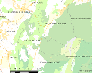
Ла-Бюисс (La Buisse, La Buisse)

- коммуна во Франции
 Hiking in Ла-Бюисс
La Buisse is a charming village located in the Isère department of the Auvergne-Rhône-Alpes region in France. It serves as a great starting point for hiking enthusiasts looking to explore the natural beauty of the area, particularly the nearby Vercors Regional Natural Park and the Chartreuse Mountains.
Hiking Opportunities:
-
Vercors Regional Natural Park: This park offers a variety of trails with stunning views of cliffs, forests, and diverse fauna and flora. You can find both easy and challenging hikes suitable for all levels.
-
Chartreuse Mountains: Just a short drive from La Buisse, the Chartreuse range presents numerous hiking options, including famous trails like the Grand Som and the Chamechaude. The landscape is characterized by limestone cliffs, lush valleys, and panoramic vistas.
-
Local Trails: There are several marked local trails around La Buisse that can be explored on foot or by mountain bike. These trails typically range from leisurely strolls through the countryside to more demanding hikes that lead to elevated viewpoints.
Tips for Hiking in La Buisse:
- Weather: Always check the weather forecast before heading out, as conditions in the mountains can change quickly.
- Gear: Wear appropriate hiking shoes and clothing layers to adjust to temperature changes during the day.
- Hydration and Food: Bring plenty of water and energy-boosting snacks, especially for longer hikes.
- Maps and Apps: Consider using hiking maps or mobile apps to navigate the trails and ensure you're on the right path.
Safety Considerations:
- Inform someone about your hiking plans and expected return time.
- Stay on marked trails to preserve the natural environment.
- Be aware of wildlife, and follow local guidelines regarding interactions with animals.
In summary, La Buisse offers a fantastic base for exploring the breathtaking landscapes of the surrounding mountains, catering to a wide range of hiking preferences and abilities. Enjoy your hike!
- Страна:

- Почтовый код: 38500
- Координаты: 45° 20' 6" N, 5° 37' 18" E


- GPS треки (wikiloc): [Ссылка]
- Площадь: 11.53 кв.км
- Население: 3144
- Веб сайт: http://www.labuisse.fr
- Википедия русская: wiki(ru)
- Википедия английская: wiki(en)
- Википедия национальная: wiki(fr)
- Хранилище Wikidata: Wikidata: Q1094487
- Катеория в википедии: [Ссылка]
- код Freebase: [/m/03g_6q6]
- код GeoNames: Альт: [6456872]
- номер SIREN: [213800618]
- код BNF: [15257890x]
- место в MusicBrainz: [1b9be772-97e7-4a38-80df-96bdc529a513]
- код муниципалитета INSEE: 38061
Граничит с регионами:


Сен-Жан-де-Муаран
- коммуна во Франции
Hiking in Сен-Жан-де-Муаран
Saint-Jean-de-Moirans is located in the Auvergne-Rhône-Alpes region of France, nestled at the foot of the Chartreuse Mountains. This picturesque area offers a variety of hiking opportunities that cater to different skill levels, from leisurely walks to more challenging treks....
- Страна:
- Почтовый код: 38430
- Координаты: 45° 20' 28" N, 5° 34' 56" E
- GPS треки (wikiloc): [Ссылка]
- Площадь: 6.43 кв.км
- Население: 3427
- Веб сайт: [Ссылка]

Сен-Жюльен-де-Ра
- коммуна во Франции
Hiking in Сен-Жюльен-де-Ра
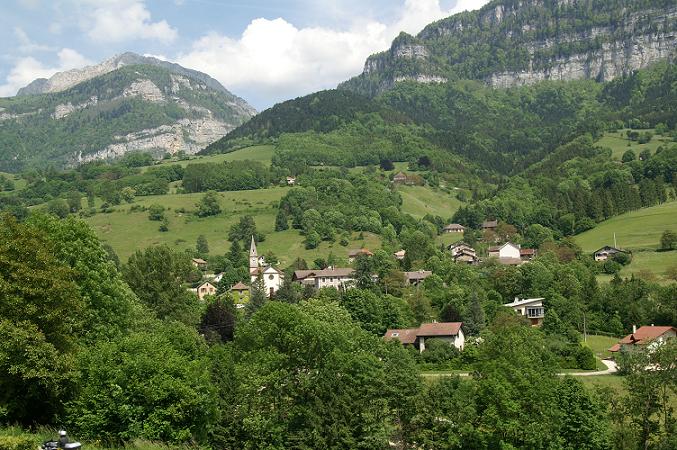
Saint-Julien-de-Raz is a charming commune in the Vaucluse department of the Provence-Alpes-Côte d'Azur region in southeastern France. Although it's not widely known as a major hiking destination, it offers access to beautiful natural surroundings that are ideal for those interested in exploring the great outdoors....
- Страна:
- Почтовый код: 38134
- Координаты: 45° 20' 59" N, 5° 39' 42" E
- GPS треки (wikiloc): [Ссылка]
- Высота над уровнем моря: 630 м m
- Площадь: 10.81 кв.км
- Население: 429
- Веб сайт: [Ссылка]

Помье-ла-Пласетт
- коммуна во Франции
Hiking in Помье-ла-Пласетт
Pommiers-la-Placette is a charming village located in the picturesque Grenoble region of France, nestled in the heart of the French Alps. This area is known for its breathtaking landscapes, offering a plethora of hiking opportunities for outdoor enthusiasts of all skill levels....
- Страна:
- Почтовый код: 38340
- Координаты: 45° 19' 3" N, 5° 39' 26" E
- GPS треки (wikiloc): [Ссылка]
- Площадь: 16.92 кв.км
- Население: 554
- Веб сайт: [Ссылка]


Кублеви
- коммуна во Франции
Hiking in Кублеви
Coublevie is a charming village located in the Auvergne-Rhône-Alpes region of France, set near the foothills of the Alps. This region offers a variety of hiking opportunities for outdoor enthusiasts. Here are some key points to consider when hiking in and around Coublevie:...
- Страна:
- Почтовый код: 38500
- Координаты: 45° 21' 20" N, 5° 37' 0" E
- GPS треки (wikiloc): [Ссылка]
- Площадь: 7.05 кв.км
- Население: 4680
- Веб сайт: [Ссылка]


Вореп
- коммуна во Франции
Hiking in Вореп
Voreppe, located in the Isère department of southeastern France, is a picturesque area that offers various hiking opportunities amid stunning natural landscapes. The proximity to the Chartreuse and Vercors mountain ranges makes it an ideal base for outdoor enthusiasts....
- Страна:
- Почтовый код: 38340
- Координаты: 45° 17' 52" N, 5° 38' 13" E
- GPS треки (wikiloc): [Ссылка]
- Площадь: 28.65 кв.км
- Население: 9441
- Веб сайт: [Ссылка]