Помье-ла-Пласетт (Pommiers-la-Placette, Pommiers-la-Placette)

- коммуна во Франции
 Hiking in Помье-ла-Пласетт
Pommiers-la-Placette is a charming village located in the picturesque Grenoble region of France, nestled in the heart of the French Alps. This area is known for its breathtaking landscapes, offering a plethora of hiking opportunities for outdoor enthusiasts of all skill levels.
Hiking Experience
-
Trail Variety: The region boasts a variety of trails that cater to different abilities. You can find gentle walks suitable for families as well as more challenging hikes for seasoned trekkers.
-
Scenic Views: Many trails offer stunning panoramic views of the surrounding mountains, valleys, and forests. The scenery changes with the seasons, providing beautiful wildflowers in spring, lush greenery in summer, vibrant foliage in autumn, and serene snowy landscapes in winter.
-
Wildlife: Hikers often have the chance to see diverse wildlife, including deer, chamois, and various bird species. The area is also rich in flora, making it a great spot for nature lovers and photographers.
-
Local Attractions: Along the hiking routes, you may encounter local landmarks, historical sites, and charming villages that add cultural depth to your hiking experience.
-
Trail Markings: Most trails in and around Pommiers-la-Placette are well-marked, making navigation straightforward. However, carrying a map or using a hiking app can be beneficial, especially if you plan to explore less-trafficked paths.
-
Weather Considerations: The weather in the Alps can change quickly, so it's essential to check forecasts before heading out. Make sure to dress in layers, wear sturdy hiking boots, and bring rain gear if necessary.
-
Safety Tips: Always inform someone of your hiking plan, carry enough water and snacks, and consider bringing a first aid kit. Additionally, cell service can be spotty in remote areas, so having a physical map can be helpful.
Getting There
Pommiers-la-Placette is accessible by car, with parking available in and around the village. Depending on your location, public transportation options may also be available, but checking local schedules is recommended.
Overall, hiking in Pommiers-la-Placette combines natural beauty with rich culture, making it a wonderful destination for a day hike or a longer outdoor adventure. Enjoy your hiking experience!
- Страна:

- Почтовый код: 38340
- Координаты: 45° 19' 3" N, 5° 39' 26" E


- GPS треки (wikiloc): [Ссылка]
- Площадь: 16.92 кв.км
- Население: 554
- Веб сайт: http://www.pommierslaplacette.fr
- Википедия русская: wiki(ru)
- Википедия английская: wiki(en)
- Википедия национальная: wiki(fr)
- Хранилище Wikidata: Wikidata: Q1069013
- Катеория в википедии: [Ссылка]
- код Freebase: [/m/03nvj6w]
- код GeoNames: Альт: [6433290]
- код BNF: [15258124f]
- код Trismegistos: [21000]
- код муниципалитета INSEE: 38312
Граничит с регионами:

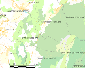
Сен-Жюльен-де-Ра
- коммуна во Франции
Hiking in Сен-Жюльен-де-Ра
Saint-Julien-de-Raz is a charming commune in the Vaucluse department of the Provence-Alpes-Côte d'Azur region in southeastern France. Although it's not widely known as a major hiking destination, it offers access to beautiful natural surroundings that are ideal for those interested in exploring the great outdoors....
- Страна:
- Почтовый код: 38134
- Координаты: 45° 20' 59" N, 5° 39' 42" E
- GPS треки (wikiloc): [Ссылка]
- Высота над уровнем моря: 630 м m
- Площадь: 10.81 кв.км
- Население: 429
- Веб сайт: [Ссылка]


Ла-Бюисс
- коммуна во Франции
Hiking in Ла-Бюисс
La Buisse is a charming village located in the Isère department of the Auvergne-Rhône-Alpes region in France. It serves as a great starting point for hiking enthusiasts looking to explore the natural beauty of the area, particularly the nearby Vercors Regional Natural Park and the Chartreuse Mountains....
- Страна:
- Почтовый код: 38500
- Координаты: 45° 20' 6" N, 5° 37' 18" E
- GPS треки (wikiloc): [Ссылка]
- Площадь: 11.53 кв.км
- Население: 3144
- Веб сайт: [Ссылка]


Мон-Сен-Мартен
- коммуна - Рона — Альпы, Изер, Гренобль
Hiking in Мон-Сен-Мартен
Mont-Saint-Martin, located in the Isère department of the Auvergne-Rhône-Alpes region in southeastern France, offers a variety of hiking opportunities that showcase the beautiful landscapes and natural features of the Alps. Here are some highlights and tips for hiking in the area:...
- Страна:
- Почтовый код: 38120
- Координаты: 45° 16' 17" N, 5° 40' 31" E
- GPS треки (wikiloc): [Ссылка]
- Площадь: 5.31 кв.км
- Население: 80

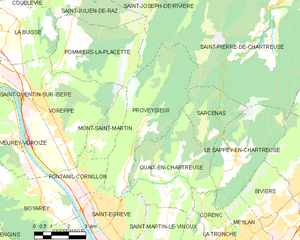
Провезьё
- коммуна во Франции
Hiking in Провезьё
Proveysieux is a charming village located in the Grenoble area of the French Alps. It's a fantastic destination for hiking enthusiasts looking to explore the natural beauty of the region. Here are some key points about hiking in Proveysieux:...
- Страна:
- Почтовый код: 38120
- Координаты: 45° 15' 46" N, 5° 41' 58" E
- GPS треки (wikiloc): [Ссылка]
- Площадь: 20.37 кв.км
- Население: 503

Сен-Пьер-де-Шартрёз
- коммуна во Франции
Hiking in Сен-Пьер-де-Шартрёз
Saint-Pierre-de-Chartreuse is a picturesque village located in the Chartreuse Mountains, in the Auvergne-Rhône-Alpes region of France. It's a popular destination for outdoor enthusiasts, particularly hikers, due to its stunning landscapes, diverse trails, and rich natural heritage. Here are some highlights and tips for hiking in this beautiful area:...
- Страна:
- Почтовый код: 38380
- Координаты: 45° 20' 33" N, 5° 48' 56" E
- GPS треки (wikiloc): [Ссылка]
- Площадь: 80.12 кв.км
- Население: 1028
- Веб сайт: [Ссылка]


Вореп
- коммуна во Франции
Hiking in Вореп
Voreppe, located in the Isère department of southeastern France, is a picturesque area that offers various hiking opportunities amid stunning natural landscapes. The proximity to the Chartreuse and Vercors mountain ranges makes it an ideal base for outdoor enthusiasts....
- Страна:
- Почтовый код: 38340
- Координаты: 45° 17' 52" N, 5° 38' 13" E
- GPS треки (wikiloc): [Ссылка]
- Площадь: 28.65 кв.км
- Население: 9441
- Веб сайт: [Ссылка]