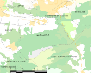
Ла-Рош-сюр-Форон (La Roche-sur-Foron, La Roche-sur-Foron)

- коммуна во Франции
 Hiking in Ла-Рош-сюр-Форон
La Roche-sur-Foron, located in the Haute-Savoie region of France, is a beautiful area for hiking enthusiasts. Nestled at the foothills of the Alps, it offers a variety of landscapes, from lush green valleys to rocky trails with breathtaking views of the surrounding mountains.
Hiking Trails
-
Nearby Mountain Trails: There are numerous trails that lead into the nearby hills and mountains, catering to different skill levels. The hikes can range from easy walks suitable for families to more challenging routes for experienced hikers.
-
The Plateau de Glieres: This area is known for its stunning vistas and historical significance. The trails here often lead to panoramic viewpoints, where hikers can enjoy views of Mont Blanc on clear days.
-
Gorges du Pont du Diable: This hike offers stunning scenery along the gorge, with paths that lead you along the river and provide opportunities for photography and nature walks.
-
Château de La Roche: A hike to the ruins of the Château de La Roche rewards you with both a glimpse into the region's history and beautiful landscape views.
Seasonal Considerations
- Summer: Ideal for hiking with generally mild weather. It's important to bring plenty of water and sunscreen, as trails can get hot.
- Fall: The foliage changes color, providing a beautiful backdrop. It’s a great time for photography and enjoying nature.
- Winter: Some trails may be suitable for snowshoeing or winter hiking, but it’s essential to check conditions and be equipped accordingly.
Essential Tips
- Maps and Guides: It's advisable to have a local map or download hiking apps that provide trail information, difficulty levels, and points of interest.
- Safety: Always inform someone about your hiking plans, carry a first-aid kit, and check the weather before heading out.
- Leave No Trace: Practice responsible hiking by sticking to marked paths and cleaning up after yourself.
Local Amenities
La Roche-sur-Foron offers charming accommodations, local eateries, and shops where you can find gear and refreshments. After a day of hiking, enjoy some local cuisine or relax in one of the tranquil parks.
In summary, La Roche-sur-Foron is a fantastic destination for hiking with diverse trails and stunning Alpine scenery, making it a wonderful spot for both casual walkers and seasoned hikers alike.
- Страна:

- Почтовый код: 74800
- Координаты: 46° 4' 1" N, 6° 18' 43" E


- GPS треки (wikiloc): [Ссылка]
- Площадь: 17.94 кв.км
- Население: 11659
- Веб сайт: http://www.larochesurforon.fr
- Википедия английская: wiki(en)
- Википедия национальная: wiki(fr)
- Хранилище Wikidata: Wikidata: Q164339
- Катеория в википедии: [Ссылка]
- код Freebase: [/m/03nt_29]
- код GeoNames: Альт: [3006770]
- номер SIREN: [217402247]
- код BNF: [152744806]
- код VIAF: Альт: [133728351]
- код GND: Альт: [4363382-1]
- код LCNAF: Альт: [n83067802]
- код тезауруса PACTOLS: [pcrt3wHdOSqwTJ]
- код муниципалитета INSEE: 74224
Граничит с регионами:
Évires
- коммуна во Франции
Hiking in Évires
Évires is a charming commune located in the Haute-Savoie region of France, close to the scenic landscapes of the Alps. Hiking in this area can be a delightful experience as it offers a mix of natural beauty, diverse trails, and beautiful panoramic views....
- Страна:
- Почтовый код: 74570
- Координаты: 46° 2' 15" N, 6° 13' 27" E
- GPS треки (wikiloc): [Ссылка]
- Площадь: 19.49 кв.км
- Население: 1426


Amancy
- коммуна во Франции
Hiking in Amancy
Amancy, located in the Haute-Savoie region of France, is a lesser-known but beautiful destination for hiking enthusiasts. Nestled near the stunning landscapes of the French Alps, it offers a variety of trails that cater to hikers of different skill levels....
- Страна:
- Почтовый код: 74800
- Координаты: 46° 4' 27" N, 6° 19' 45" E
- GPS треки (wikiloc): [Ссылка]
- Площадь: 8.62 кв.км
- Население: 2492
- Веб сайт: [Ссылка]

Saint-Laurent, Haute-Savoie
Hiking in Saint-Laurent, Haute-Savoie
Hiking in Saint-Laurent, located in the Haute-Savoie region of the French Alps, offers a stunning array of options for outdoor enthusiasts. This area is known for its breathtaking landscapes, charming alpine villages, and diverse trails that cater to hikers of all skill levels....
- Страна:
- Почтовый код: 74800
- Координаты: 46° 2' 48" N, 6° 21' 33" E
- GPS треки (wikiloc): [Ссылка]
- Площадь: 10.96 кв.км
- Население: 818


Cornier
- коммуна во Франции
Hiking in Cornier
It seems there might be a small typo in your request, as there isn't a well-known hiking region called "Cornier." However, if you meant "Cornwall," I can provide information about hiking in that area. If there's a different location you were referring to, please let me know!...
- Страна:
- Почтовый код: 74800
- Координаты: 46° 5' 34" N, 6° 17' 59" E
- GPS треки (wikiloc): [Ссылка]
- Площадь: 6.78 кв.км
- Население: 1276
- Веб сайт: [Ссылка]


Etaux
- коммуна во Франции
Hiking in Etaux
Etaux is a charming village located in the Haute-Savoie region of the French Alps. It’s a lesser-known destination that offers beautiful landscapes, making it a great spot for hiking enthusiasts. Here are some highlights and tips for hiking in the Etaux area:...
- Страна:
- Почтовый код: 74800
- Координаты: 46° 3' 56" N, 6° 17' 38" E
- GPS треки (wikiloc): [Ссылка]
- Площадь: 13.69 кв.км
- Население: 1913


Le Petit-Bornand-les-Glières
- коммуна во Франции
Hiking in Le Petit-Bornand-les-Glières
Le Petit-Bornand-les-Glières is a beautiful destination for hiking enthusiasts, nestled in the French Alps in the Haute-Savoie region. This charming village offers a range of hiking trails suited for all experience levels, as well as breathtaking scenery....
- Страна:
- Почтовый код: 74130
- Координаты: 46° 0' 2" N, 6° 23' 48" E
- GPS треки (wikiloc): [Ссылка]
- Площадь: 53.42 кв.км
- Население: 1118
- Веб сайт: [Ссылка]


Thorens-Glières
- коммуна во Франции
Hiking in Thorens-Glières
Thorens-Glières, located in the Haute-Savoie region of the French Alps, is a beautiful area for hiking, offering a range of trails that cater to different skill levels and experiences. The region is not only renowned for its stunning mountain landscapes but also for its historical significance, particularly related to the French Resistance during World War II....
- Страна:
- Почтовый код: 74570
- Координаты: 45° 59' 49" N, 6° 14' 49" E
- GPS треки (wikiloc): [Ссылка]
- Площадь: 63.05 кв.км
- Население: 3153


Saint-Sixt
- коммуна во Франции
Hiking in Saint-Sixt
Saint-Sixt is a charming commune located in the Haute-Savoie region of the Auvergne-Rhône-Alpes in southeastern France. It offers a range of hiking opportunities for both beginners and experienced hikers, with stunning landscapes and diverse natural environments to explore. Here are some highlights about hiking in the area:...
- Страна:
- Почтовый код: 74800
- Координаты: 46° 3' 10" N, 6° 19' 46" E
- GPS треки (wikiloc): [Ссылка]
- Площадь: 5.21 кв.км
- Население: 996