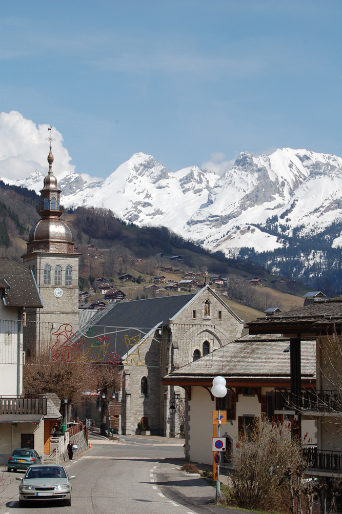
Le Reposoir (Le Reposoir)

- коммуна во Франции
 Hiking in Le Reposoir
Le Reposoir is a beautiful area located in the French Alps, specifically in the Haute-Savoie region, well-known for its scenic views, lush landscapes, and quaint alpine villages. While it may not be as popular as some other hiking destinations in the Alps, it offers a variety of hiking opportunities for both beginners and experienced hikers.
Hiking Trails:
-
Maison de la Nature Trail: This is an easy family-friendly hike, perfect for those looking to enjoy a leisurely stroll in nature. The trail often includes informative panels about the local flora and fauna.
-
Le Col de la Flée: A moderate hike that offers breathtaking views of the surrounding mountains. This trail is suitable for intermediate hikers and provides a wonderful experience of the alpine environment.
-
Boucle des Praz: This is a circular trail that offers varied terrain and picturesque views of the nearby Monts de Gu Hurtières. It can be a good option for a short day hike.
-
Grand Bargy: For those seeking a challenge, the ascent to Grand Bargy provides spectacular panoramic views. Hikers should be prepared for more challenging terrain and altitude.
Best Time to Hike:
The best time for hiking in Le Reposoir is typically from late spring to early fall (May to September), as the weather is generally mild, and most trails are accessible. In winter, some trails may be covered in snow, making them suitable for snowshoeing or skiing.
Preparation and Tips:
- Weather: Always check the weather forecast before heading out, as conditions in the mountains can change rapidly.
- Gear: Wear appropriate hiking footwear and carry trekking poles if needed. A good backpack with essentials like water, snacks, a first-aid kit, and a map is advisable.
- Safety: Let someone know your hiking plans and estimated return time. Familiarize yourself with the trails and follow signage.
Additional Activities:
Apart from hiking, Le Reposoir offers opportunities for mountain biking, wildlife watching, and enjoying the local culture and cuisine in nearby towns and villages.
Overall, hiking in Le Reposoir provides an excellent chance to explore the stunning natural beauty of the Alps and enjoy a peaceful and rejuvenating experience in the great outdoors.
- Страна:

- Почтовый код: 74950
- Координаты: 46° 0' 41" N, 6° 32' 7" E


- GPS треки (wikiloc): [Ссылка]
- Площадь: 37.36 кв.км
- Население: 509
- Веб сайт: http://www.lereposoir.fr
- Википедия английская: wiki(en)
- Википедия национальная: wiki(fr)
- Хранилище Wikidata: Wikidata: Q746753
- Катеория в википедии: [Ссылка]
- код Freebase: [/m/03nt_18]
- код GeoNames: Альт: [6617612]
- номер SIREN: [217402213]
- код BNF: [152744779]
- код муниципалитета INSEE: 74221
Граничит с регионами:


Mont-Saxonnex
- коммуна во Франции
Hiking in Mont-Saxonnex
Mont-Saxonnex is a charming commune located in the Haute-Savoie region of the French Alps, making it an attractive destination for hiking enthusiasts. The area is known for its beautiful landscapes, diverse terrain, and panoramic views of the surrounding mountains, including the Aravis range. Here are some highlights and information about hiking in Mont-Saxonnex:...
- Страна:
- Почтовый код: 74130
- Координаты: 46° 3' 16" N, 6° 29' 4" E
- GPS треки (wikiloc): [Ссылка]
- Площадь: 26.28 кв.км
- Население: 1643
- Веб сайт: [Ссылка]

Le Grand-Bornand
- коммуна во Франции
Hiking in Le Grand-Bornand
Le Grand-Bornand is a picturesque village located in the French Alps, within the Haute-Savoie department. It offers a stunning backdrop of mountains and lush landscapes, making it a popular destination for hiking enthusiasts. Here's what you need to know about hiking in Le Grand-Bornand:...
- Страна:
- Почтовый код: 74450
- Координаты: 45° 56' 31" N, 6° 25' 31" E
- GPS треки (wikiloc): [Ссылка]
- Площадь: 61.42 кв.км
- Население: 2154
- Веб сайт: [Ссылка]


Magland
- коммуна во Франции
Hiking in Magland
Magland, located in the Haute-Savoie region of France, is a beautiful destination for hiking enthusiasts. Nestled in the heart of the French Alps, this charming village offers stunning views, diverse terrains, and a range of hiking trails suitable for all skill levels. Here’s what you need to know about hiking in Magland:...
- Страна:
- Почтовый код: 74300
- Координаты: 46° 1' 19" N, 6° 37' 11" E
- GPS треки (wikiloc): [Ссылка]
- Площадь: 40.32 кв.км
- Население: 3301
- Веб сайт: [Ссылка]


Nancy-sur-Cluses
- коммуна во Франции
Hiking in Nancy-sur-Cluses
Nancy-sur-Cluses is a picturesque village located in the Haute-Savoie region of the French Alps, offering a variety of hiking opportunities for outdoor enthusiasts. The area's stunning mountainous landscapes, lush green valleys, and charming alpine atmosphere make it an appealing destination for hikers of all levels. Here are some highlights about hiking in Nancy-sur-Cluses:...
- Страна:
- Почтовый код: 74300
- Координаты: 46° 2' 36" N, 6° 34' 39" E
- GPS треки (wikiloc): [Ссылка]
- Площадь: 14.22 кв.км
- Население: 429
- Веб сайт: [Ссылка]

Scionzier
- коммуна во Франции
Hiking in Scionzier
Scionzier, located in the Haute-Savoie region of France, benefits from its proximity to the stunning French Alps, making it a great starting point for various hiking adventures. The area offers diverse trails suitable for different skill levels, from leisurely walks to more challenging treks....
- Страна:
- Почтовый код: 74950
- Координаты: 46° 3' 26" N, 6° 33' 0" E
- GPS треки (wikiloc): [Ссылка]
- Площадь: 10.62 кв.км
- Население: 8457
- Веб сайт: [Ссылка]


Салланш
- коммуна во Франции
Hiking in Салланш
Sallanches, located in the Haute-Savoie region of the French Alps, is an excellent destination for hiking enthusiasts. Nestled between Mont Blanc and the Aravis mountain range, it offers stunning alpine scenery, diverse trails, and opportunities for outdoor activities year-round. Here are some notable aspects of hiking in the Sallanches area:...
- Страна:
- Почтовый код: 74700
- Координаты: 45° 56' 11" N, 6° 37' 55" E
- GPS треки (wikiloc): [Ссылка]
- Площадь: 65.87 кв.км
- Население: 16050
- Веб сайт: [Ссылка]


Marnaz
- коммуна во Франции
Hiking in Marnaz
Marnaz is a picturesque town located in the Haute-Savoie region of the French Alps. It offers a range of hiking opportunities that cater to different skill levels and preferences. Here’s a breakdown of what you can expect when hiking in and around Marnaz:...
- Страна:
- Почтовый код: 74460
- Координаты: 46° 3' 33" N, 6° 31' 33" E
- GPS треки (wikiloc): [Ссылка]
- Площадь: 9.02 кв.км
- Население: 5365
- Веб сайт: [Ссылка]