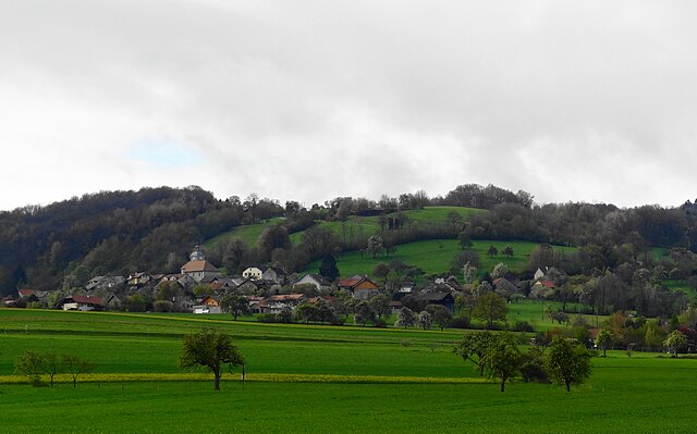
Le Sappey (Le Sappey)

- коммуна во Франции
 Hiking in Le Sappey
Le Sappey-en-Chartreuse is a charming village located in the Chartreuse Mountains, near Grenoble in the French Alps. It's a fantastic base for hiking enthusiasts, offering a variety of trails suitable for all levels of experience. Here’s what you can expect when hiking in Le Sappey:
Trail Options
-
Lacs de Crop: This relatively easy hike takes you to beautiful mountain lakes surrounded by stunning scenery. It’s perfect for families and those looking for a leisurely day in nature.
-
Mont Jalla: A moderate hike that provides breathtaking views of the Grenoble valley and surrounding peaks. The trail includes some steep sections, but the panoramic views at the summit are worth the effort.
-
Le Col de Porte: This trail offers a great opportunity to explore the alpine flora and fauna. It’s a well-marked path and not too difficult, making it ideal for beginners.
-
Crêtes de Belledonne: For more experienced hikers, this trail offers more challenging terrain and rewards you with awe-inspiring views. It’s characterized by its rocky paths and requires good physical condition.
Practical Considerations
-
Best Time to Hike: The best seasons for hiking in Le Sappey are late spring through early autumn (May to October). In winter, some trails may be suitable for snowshoeing, but it’s essential to check current conditions.
-
Safety: Always check weather conditions before heading out, as mountain weather can change rapidly. Bring essentials such as water, snacks, a map, and a fully charged phone.
-
Local Highlights: After a day of hiking, take time to explore the village, which has local restaurants and shops offering delicious regional cuisine and artisan products.
Getting There
Le Sappey-en-Chartreuse is easily accessible by car, being just a short drive from Grenoble. Public transport options may include buses, but checking current schedules is advisable.
Additional Tips
- Consider hiring a local guide if you're unfamiliar with mountain hiking or want to learn about the local ecology.
- Be aware of wildlife in the area and practice Leave No Trace principles to help preserve the natural beauty of the landscape.
Enjoy your hiking adventure in Le Sappey! The combination of beautiful trails and stunning alpine scenery makes it a memorable experience.
- Страна:

- Почтовый код: 74350
- Координаты: 46° 5' 19" N, 6° 9' 57" E


- GPS треки (wikiloc): [Ссылка]
- Площадь: 13.72 кв.км
- Население: 407
- Веб сайт: http://www.lesappey.fr
- Википедия английская: wiki(en)
- Википедия национальная: wiki(fr)
- Хранилище Wikidata: Wikidata: Q845352
- Катеория в википедии: [Ссылка]
- код Freebase: [/m/03ntzgq]
- код GeoNames: Альт: [6456428]
- номер SIREN: [217402593]
- код BNF: [15274513b]
- код муниципалитета INSEE: 74259
Граничит с регионами:


Arbusigny
- коммуна во Франции
Hiking in Arbusigny
Arbusigny, located in the Haute-Savoie region of France, offers a variety of hiking opportunities that cater to different skill levels. The area is characterized by beautiful landscapes, including rolling hills, forests, and breathtaking views of the surrounding mountains....
- Страна:
- Почтовый код: 74930
- Координаты: 46° 5' 30" N, 6° 13' 6" E
- GPS треки (wikiloc): [Ссылка]
- Площадь: 12.25 кв.км
- Население: 1098
- Веб сайт: [Ссылка]


Archamps
- коммуна во Франции
Hiking in Archamps
Archamps, located near the border of France and Switzerland, offers a unique blend of scenic landscapes that cater to hikers of various skill levels. The area is characterized by its lush green hills, wooded areas, and panoramic views of the surrounding mountains, making it a great destination for nature enthusiasts....
- Страна:
- Почтовый код: 74160
- Координаты: 46° 8' 8" N, 6° 7' 57" E
- GPS треки (wikiloc): [Ссылка]
- Площадь: 10.69 кв.км
- Население: 2585


La Muraz
- коммуна во Франции
Hiking in La Muraz
La Muraz is a charming village located in the Swiss Alps, often known for its stunning landscapes and serene hiking routes. Situated close to the border between Switzerland and France, it offers an array of hiking opportunities that cater to different skill levels. Here are some key points to consider if you’re planning to hike in La Muraz:...
- Страна:
- Почтовый код: 74560
- Координаты: 46° 7' 24" N, 6° 12' 20" E
- GPS треки (wikiloc): [Ссылка]
- Площадь: 14.38 кв.км
- Население: 1059


Beaumont
Hiking in Beaumont
Beaumont in Haute-Savoie is a charming destination for hiking enthusiasts. Located near the French Alps, this area offers a variety of trails that allow you to immerse yourself in stunning natural landscapes, including mountains, forests, and alpine meadows....
- Страна:
- Почтовый код: 74160
- Координаты: 46° 5' 41" N, 6° 6' 5" E
- GPS треки (wikiloc): [Ссылка]
- Площадь: 9.74 кв.км
- Население: 2685
- Веб сайт: [Ссылка]


Menthonnex-en-Bornes
- коммуна во Франции
Hiking in Menthonnex-en-Bornes
Menthonnex-en-Bornes is a picturesque village located in the Auvergne-Rhône-Alpes region of France, near the French Alps. It offers a variety of hiking opportunities for both novice and experienced hikers, thanks to its beautiful landscapes, rolling hills, and proximity to the mountains....
- Страна:
- Почтовый код: 74350
- Координаты: 46° 3' 10" N, 6° 10' 24" E
- GPS треки (wikiloc): [Ссылка]
- Площадь: 8.48 кв.км
- Население: 1074
- Веб сайт: [Ссылка]

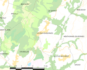
Vovray-en-Bornes
- коммуна во Франции
Hiking in Vovray-en-Bornes
Vovray-en-Bornes is a picturesque village located in the Haute-Savoie region of France, which offers a variety of hiking opportunities for outdoor enthusiasts. The area is characterized by stunning natural beauty, including forests, rolling hills, and views of the nearby mountains....
- Страна:
- Почтовый код: 74350
- Координаты: 46° 3' 56" N, 6° 8' 33" E
- GPS треки (wikiloc): [Ссылка]
- Площадь: 6.57 кв.км
- Население: 441
- Веб сайт: [Ссылка]

Présilly
- коммуна во Франции
Hiking in Présilly
Présilly, located in the Haute-Savoie region of France, offers a variety of hiking opportunities amidst stunning Alpine scenery. This picturesque village is well-positioned near the French-Swiss border, providing access to beautiful trails and natural landscapes....
- Страна:
- Почтовый код: 74160
- Координаты: 46° 5' 35" N, 6° 4' 40" E
- GPS треки (wikiloc): [Ссылка]
- Площадь: 8.66 кв.км
- Население: 774