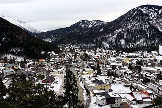
Лойташ (Leutasch, Leutasch)
 Hiking in Лойташ
Leutasch is a stunning valley located in the Tyrol region of Austria, near the border with Germany. It's well-known for its picturesque landscapes, breath-taking mountain views, and a variety of hiking trails suitable for all experience levels. Here’s what you need to know about hiking in Leutasch:
Trail Options
-
Easy Trails: Leutasch offers several easy, family-friendly hiking trails. The "Leutascher Geisterklamm" is a beautiful gorge that provides a relatively easy hike with incredible views and serene surroundings.
-
Moderate Trails: There are medium-difficulty routes such as the "Kühgrabenweg" where hikers can enjoy beautiful alpine meadows, rustic farms, and charming local wildlife.
-
Challenging Trails: For experienced hikers, there are more demanding trails that lead to higher altitudes offering panoramic views. One popular option is the hike up to the Mittenwald Alps, which provides stunning vistas of the surrounding peaks.
Scenic Features
- Natural Attractions: The area is rich in natural beauty with picturesque mountain lakes, lush forests, and diverse flora and fauna. The nearby Wetterstein Mountains provide a dramatic backdrop to many trails.
- Cultural Points: Some trails pass by traditional Tyrolean villages, giving hikers a taste of the local culture and history.
Practical Tips
- Trail Markings: The trails in Leutasch are well-marked, but it's wise to have a map or a GPS device, especially for the more remote areas.
- Weather Considerations: Weather can change rapidly in the mountains, so check forecasts and be prepared with appropriate gear.
- Season: The best time for hiking in Leutasch is from late spring to early autumn. Some trails may be snow-covered in early spring or late autumn.
Additional Activities
- Winter Hiking: In winter, many trails are maintained for winter hiking or snowshoeing, providing a completely different, peaceful experience.
- Wellness Options: Leutasch is also known for its wellness offerings, so combining hiking with some relaxation can be a great way to enjoy the region.
Safety
Stay on marked paths, carry adequate water and snacks, and inform someone of your hiking plans, especially if venturing into less traveled areas.
Hiking in Leutasch is not just a physical challenge; it's an opportunity to immerse yourself in the stunning natural landscapes of Austria. Enjoy your adventure!
- Страна:

- Почтовый код: 6105
- Телефонный код: 05214
- Код автомобильного номера: IL
- Координаты: 47° 22' 0" N, 11° 9' 0" E


- GPS треки (wikiloc): [Ссылка]
- Высота над уровнем моря: 1136 м m
- Площадь: 103.1 кв.км
- Население: 2380
- Веб сайт: http://www.leutasch.at/
- Википедия русская: wiki(ru)
- Википедия английская: wiki(en)
- Википедия национальная: wiki(de)
- Хранилище Wikidata: Wikidata: Q665186
- Катеория в википедии: [Ссылка]
- код Freebase: [/m/02w04nk]
- код GeoNames: Альт: [3319549]
- код VIAF: Альт: [124479584]
- код GND: Альт: [4274016-2]
- идентификатор местоположения ArchINFORM: [10287]
- код LCNAF: Альт: [n92087536]
- код австрийского муниципалитета: [70326]
Граничит с регионами:


Гармиш-Партенкирхен
- город в Баварии
Hiking in Гармиш-Партенкирхен
Garmisch-Partenkirchen, located in the Bavarian Alps of Germany, is a fantastic destination for hiking enthusiasts. Renowned for its stunning alpine scenery, the area offers a variety of trails suitable for all skill levels, ranging from easy walks to challenging mountain hikes. Here are some highlights and tips for hiking in Garmisch-Partenkirchen:...
- Страна:

- Почтовый код: 82467
- Телефонный код: 08821
- Код автомобильного номера: GAP
- Координаты: 47° 30' 0" N, 11° 5' 0" E
- GPS треки (wikiloc): [Ссылка]
- Высота над уровнем моря: 708 м m
- Площадь: 205.66 кв.км
- Население: 26821
- Веб сайт: [Ссылка]


Миттенвальд
Hiking in Миттенвальд
Mittenwald, located in Bavaria, Germany, is a beautiful destination for hiking enthusiasts. Nestled in the Karwendel Mountain range, it offers a variety of trails that cater to all levels of hikers, from beginners to seasoned adventurers. Here are some highlights about hiking in the area:...
- Страна:
- Почтовый код: 82481
- Телефонный код: 08823
- Код автомобильного номера: GAP
- Координаты: 47° 25' 0" N, 11° 15' 0" E
- GPS треки (wikiloc): [Ссылка]
- Высота над уровнем моря: 923 м m
- Площадь: 132.85 кв.км
- Население: 7387
- Веб сайт: [Ссылка]
Шарниц
Hiking in Шарниц
Scharnitz is a picturesque village located at the border between Germany and Austria, serving as a perfect starting point for various hiking adventures in the Tyrolean Alps. The area is known for its stunning natural beauty, diverse trails, and opportunities for outdoor activities....
- Страна:
- Почтовый код: 6108
- Телефонный код: 05213
- Код автомобильного номера: IL
- Координаты: 47° 23' 18" N, 11° 15' 54" E
- GPS треки (wikiloc): [Ссылка]
- Высота над уровнем моря: 964 м m
- Площадь: 158.77 кв.км
- Население: 1403
- Веб сайт: [Ссылка]