
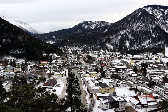
Миттенвальд (Mittenwald, Mittenwald)

 Hiking in Миттенвальд
Mittenwald, located in Bavaria, Germany, is a beautiful destination for hiking enthusiasts. Nestled in the Karwendel Mountain range, it offers a variety of trails that cater to all levels of hikers, from beginners to seasoned adventurers. Here are some highlights about hiking in the area:
Scenic Trails
-
Kranzberg: This mountain is easily accessible and features well-marked trails. The summit offers stunning panoramic views of the surrounding mountains and valleys.
-
Leutaschklamm Gorge: A spectacular walk through a gorge with wooden walkways and bridges. It’s relatively easy but provides dramatic scenery and is suitable for families.
-
Buchenberger Höhenweg: A moderate trail that offers breathtaking views over the surrounding area and is lined with beautiful alpine flora.
-
Karwendel Nature Park: Explore numerous trails within this large nature reserve, where you can encounter diverse wildlife and stunning landscapes.
Tips for Hiking in Mittenwald
-
Trail Markings: The trails are usually well-marked with signs indicating difficulty levels and directions. Familiarize yourself with the local map or download a hiking app.
-
Seasonal Considerations: The best time for hiking is from late spring to early autumn. Snow can linger in higher areas until late June, so check local conditions before heading out.
-
Equipment: Wear appropriate footwear—hiking boots are recommended. Bring layers of clothing, as temperatures can change rapidly in the mountains.
-
Safety: Always inform someone about your hiking plans and expected return time. Take a small first-aid kit, sufficient water, and snacks.
-
Local Resources: The Mittenwald tourist office can provide maps, information on guided hikes, and suggestions based on your skill level.
Wildlife and Nature
While hiking, you may encounter a variety of wildlife, including ibex, chamois, and various birds. The region is also known for its rich plant life, especially in spring and summer months.
Additional Activities
Aside from hiking, Mittenwald offers opportunities for mountain biking, climbing, and exploring the charming town with its traditional Bavarian architecture and history of violin making.
Whether you are seeking a leisurely hike or a challenging mountain trail, Mittenwald has something for everyone, making it an ideal spot for a hiking adventure!
- Страна:

- Почтовый код: 82481
- Телефонный код: 08823
- Код автомобильного номера: GAP
- Координаты: 47° 25' 0" N, 11° 15' 0" E


- GPS треки (wikiloc): [Ссылка]
- Высота над уровнем моря: 923 м m
- Площадь: 132.85 кв.км
- Население: 7387
- Веб сайт: http://www.mittenwald.de
- Википедия русская: wiki(ru)
- Википедия английская: wiki(en)
- Википедия национальная: wiki(de)
- Хранилище Wikidata: Wikidata: Q127553
- Галерея изображений в википедии: [Ссылка]
- Катеория в википедии: [Ссылка]
- код Freebase: [/m/026xpy4]
- код GeoNames: Альт: [6558815]
- код VIAF: Альт: [124970159]
- ID отношения в OpenStreetMap: [939341]
- код GND: Альт: [4039732-4]
- идентификатор местоположения ArchINFORM: [9691]
- код LCNAF: Альт: [n85308096]
- код в энциклопедии «Британника онлайн»: [place/Mittenwald]
- код Historical Gazetteer: [object_300700]
- код места в Facebook: [105497246151542]
- Bavarikon ID: [ODB_A00001127]
- код NKC: [ge940590]
- dmoz: Альт: [Regional/Europe/Germany/States/Bavaria/Localities/Mittenwald/]
- идентификатор муниципалитетов в Германии: 09180123
Граничит с регионами:


Гармиш-Партенкирхен
- город в Баварии
Hiking in Гармиш-Партенкирхен
Garmisch-Partenkirchen, located in the Bavarian Alps of Germany, is a fantastic destination for hiking enthusiasts. Renowned for its stunning alpine scenery, the area offers a variety of trails suitable for all skill levels, ranging from easy walks to challenging mountain hikes. Here are some highlights and tips for hiking in Garmisch-Partenkirchen:...
- Страна:
- Почтовый код: 82467
- Телефонный код: 08821
- Код автомобильного номера: GAP
- Координаты: 47° 30' 0" N, 11° 5' 0" E
- GPS треки (wikiloc): [Ссылка]
- Высота над уровнем моря: 708 м m
- Площадь: 205.66 кв.км
- Население: 26821
- Веб сайт: [Ссылка]


Фомп
Hiking in Фомп
Vomp, located in the Tyrol region of Austria, is a charming village that serves as a gateway to stunning hiking experiences in the surrounding mountains. Here are some key points about hiking in and around Vomp:...
- Страна:

- Код автомобильного номера: SZ
- Координаты: 47° 20' 32" N, 11° 41' 0" E
- GPS треки (wikiloc): [Ссылка]
- Высота над уровнем моря: 563 м m
- Площадь: 182.61 кв.км
- Население: 5146
- Веб сайт: [Ссылка]

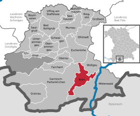
Крюн
Hiking in Крюн
Krün is a charming village located in Bavaria, Germany, surrounded by the stunning landscapes of the Alps. It serves as a fantastic base for hiking enthusiasts, offering a variety of trails that cater to different skill levels and preferences....
- Страна:
- Почтовый код: 82493; 82467; 82494
- Телефонный код: 08825
- Код автомобильного номера: GAP
- Координаты: 47° 30' 0" N, 11° 17' 0" E
- GPS треки (wikiloc): [Ссылка]
- Высота над уровнем моря: 875 м m
- Площадь: 36.31 кв.км
- Население: 1745
- Веб сайт: [Ссылка]
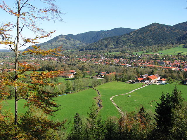
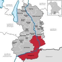
Ленгрис
Hiking in Ленгрис
Lenggries is a charming town located in Bavaria, Germany, and is surrounded by beautiful mountains, making it a great destination for hiking enthusiasts. The area offers a variety of trails suitable for all levels, from leisurely walks to challenging hikes, all amidst stunning natural scenery....
- Страна:
- Почтовый код: 83661
- Телефонный код: 08042
- Координаты: 47° 40' 49" N, 11° 34' 26" E
- GPS треки (wikiloc): [Ссылка]
- Высота над уровнем моря: 679 м m
- Площадь: 242.90 кв.км
- Население: 10001
- Веб сайт: [Ссылка]


Вальгау
Hiking in Вальгау
Wallgau is a charming village located in the Bavarian Alps of Germany, nestled at the edge of the Karwendel mountain range and close to the pristine shores of the Walchensee lake. It’s an excellent spot for hiking enthusiasts, offering a variety of trails that cater to different skill levels. Here’s an overview of what to expect when hiking in and around Wallgau:...
- Страна:
- Почтовый код: 82499
- Телефонный код: 08825
- Код автомобильного номера: GAP
- Координаты: 47° 31' 0" N, 11° 17' 0" E
- GPS треки (wikiloc): [Ссылка]
- Высота над уровнем моря: 866 м m
- Площадь: 33.96 кв.км
- Население: 1170
- Веб сайт: [Ссылка]
Шарниц
Hiking in Шарниц
Scharnitz is a picturesque village located at the border between Germany and Austria, serving as a perfect starting point for various hiking adventures in the Tyrolean Alps. The area is known for its stunning natural beauty, diverse trails, and opportunities for outdoor activities....
- Страна:
- Почтовый код: 6108
- Телефонный код: 05213
- Код автомобильного номера: IL
- Координаты: 47° 23' 18" N, 11° 15' 54" E
- GPS треки (wikiloc): [Ссылка]
- Высота над уровнем моря: 964 м m
- Площадь: 158.77 кв.км
- Население: 1403
- Веб сайт: [Ссылка]

Лойташ
Hiking in Лойташ
Leutasch is a stunning valley located in the Tyrol region of Austria, near the border with Germany. It's well-known for its picturesque landscapes, breath-taking mountain views, and a variety of hiking trails suitable for all experience levels. Here’s what you need to know about hiking in Leutasch:...
- Страна:
- Почтовый код: 6105
- Телефонный код: 05214
- Код автомобильного номера: IL
- Координаты: 47° 22' 0" N, 11° 9' 0" E
- GPS треки (wikiloc): [Ссылка]
- Высота над уровнем моря: 1136 м m
- Площадь: 103.1 кв.км
- Население: 2380
- Веб сайт: [Ссылка]