Локарно (Locarno District, Bezirk Locarno)

- округ кантона Тичино (Швейцария)
 Hiking in Локарно
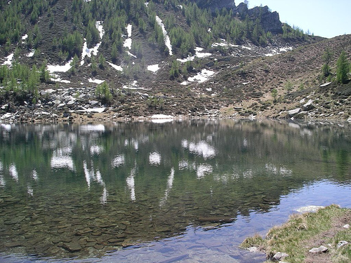
The Locarno District, located in the Italian-speaking part of Switzerland, is renowned for its stunning natural landscapes, scenic views, and a variety of hiking trails suitable for all levels of hikers. Here are some highlights and tips for hiking in the Locarno District:
Scenic Trails
-
Lago Maggiore: Trails around Lake Maggiore offer easy walks along the lakeside with beautiful views and access to charming towns like Locarno and Ascona.
-
Cimetta Trail: This hike starts from the top of the funicular railway and offers breathtaking panoramic views of the surrounding mountains and lakes. It's a moderately challenging trail.
-
Sentiero dell’Olivo: A delightful trail that meanders through olive groves and offers insights into local agriculture, history, and flora. The path is generally easy and suitable for families.
-
Monte Verità: A short yet rewarding hike (or a longer trek if you go beyond) leads to this historic and cultural site. The area features beautiful nature and a rich history related to its cultural movements.
Key Points
-
Trail Markers: Most trails are well-marked with Swiss hiking signs. However, it’s always wise to carry a map or GPS for your safety.
-
Difficulty Levels: Trails vary from easy lakeside walks to more challenging mountain hikes. Always check the difficulty level and assess your fitness before setting out.
-
Weather Conditions: The weather can change rapidly in the mountains; ensure you’re prepared with appropriate clothing and gear.
-
Best Seasons: The best times for hiking in Locarno are spring (late March to early June) and autumn (September to November) when the weather is generally mild and crowds are smaller.
Tips for a Safe and Enjoyable Hike
-
Stay Hydrated: Always bring enough water, especially on longer hikes.
-
Pack Snacks: Carry energy-rich snacks to keep your energy levels up.
-
Respect Nature: Follow local guidelines to minimize impact on the environment, and stick to designated trails.
-
Public Transport: Utilize the excellent public transport services in the region to access trailheads if you’re not driving.
-
Local Guides: Consider hiring a local hiking guide for a unique experience, especially if you're unfamiliar with the area or want to learn more about local flora, fauna, and culture.
Hiking in the Locarno District provides an excellent opportunity to explore the stunning Swiss landscape while enjoying the rich culture and charm of this picturesque region. Whether you're looking for a peaceful stroll or an adventurous trek, there's something for every hiking enthusiast.
- Страна:

- Столица: Локарно
- Код автомобильного номера: TI
- Координаты: 46° 10' 0" N, 8° 48' 0" E


- GPS треки (wikiloc): [Ссылка]
- Высота над уровнем моря: 247 м m
- Площадь: 550.9 кв.км
- Википедия русская: wiki(ru)
- Википедия английская: wiki(en)
- Википедия национальная: wiki(de)
- Хранилище Wikidata: Wikidata: Q660653
- Катеория в википедии: [Ссылка]
- код Freebase: [/m/0grwm9]
- код GeoNames: Альт: [6458750]
- идентификатор местоположения ArchINFORM: [42225]
- идентификатор HDS: [8544]
Включает регионы:

Локарно
- подокруг округа Локарно
Hiking in Локарно
Kreis Locarno, located in the Italian-speaking Ticino canton of Switzerland, is a beautiful area known for its stunning landscapes, diverse hiking trails, and mild climate. Here’s a comprehensive overview of what you can expect when hiking in this region:...
- Страна:
- Столица: Локарно

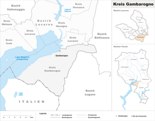
Gambarogno
Hiking in Gambarogno
Kreis Gambarogno, located in the Ticino region of Switzerland, offers a variety of hiking opportunities that cater to different skill levels. The area is known for its stunning landscapes, picturesque views of Lake Maggiore, and lush greenery, making it a great destination for outdoor enthusiasts....
- Страна:

Kreis Verzasca
Hiking in Kreis Verzasca
Kreis Verzasca is a stunning area in the Ticino region of Switzerland known for its breathtaking landscapes, picturesque villages, and the iconic Verzasca River. Hiking in this region offers a variety of trails that cater to different skill levels, making it a fantastic destination for both novice and experienced hikers....
- Страна:

Исоле
Hiking in Исоле
Kreis Isole, often characterized by its stunning natural landscapes, offers a variety of hiking opportunities suitable for all experience levels. Here are some key points to consider if you're planning to hike in this region:...
- Страна:

Навенья
- район в кантоне Тичино, Швейцария
Hiking in Навенья
Kreis Navegna, nestled in the scenic region of Italy, offers a stunning backdrop for hiking enthusiasts. This area is characterized by its varied landscapes, including rolling hills, dense forests, and picturesque valleys, making it an ideal destination for both casual walkers and seasoned trekkers....
- Страна:
Kreis Onsernone
Hiking in Kreis Onsernone
Kreis Onsernone, located in the canton of Ticino in Switzerland, is known for its stunning natural beauty and offers a variety of hiking opportunities. Nestled in the southern Swiss Alps, the region features impressive landscapes, charming villages, and scenic views that make it an attractive destination for hikers of all skill levels....
- Страна:

Melezza Subdistrict
Hiking in Melezza Subdistrict
Kreis Melezza is a scenic region located in the Ticino canton of Switzerland, known for its stunning landscapes and diverse hiking opportunities. The area is characterized by dramatic valleys, lush forests, and picturesque mountain views, making it a popular destination for hikers of all skill levels....
- Страна:
Граничит с регионами:
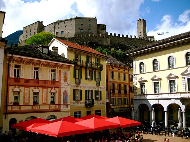

Беллинцона
Hiking in Беллинцона
Bellinzona District, located in the Swiss canton of Ticino, is a fantastic destination for hiking enthusiasts due to its stunning landscapes, rich history, and mild Mediterranean climate. Here’s an overview of what you can expect when hiking in this region:...
- Страна:
- Столица: Беллинцона
- Код автомобильного номера: TI
- Координаты: 46° 12' 0" N, 9° 1' 0" E
- GPS треки (wikiloc): [Ссылка]
- Высота над уровнем моря: 227 м m
- Площадь: 205.6 кв.км
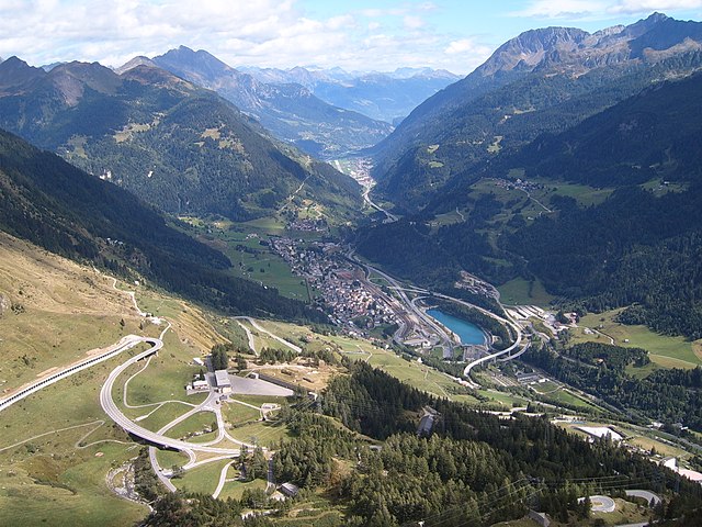

Левентина
Hiking in Левентина
Leventina District, located in the Swiss canton of Ticino, is a fantastic destination for hiking enthusiasts. This valley is known for its stunning landscapes, charming villages, and rich cultural heritage. Here are some key features and highlights of hiking in the Leventina District:...
- Страна:
- Код автомобильного номера: TI
- Координаты: 46° 29' 0" N, 8° 48' 0" E
- GPS треки (wikiloc): [Ссылка]
- Высота над уровнем моря: 1753 м m
- Площадь: 479.7 кв.км


Ривьера
Hiking in Ривьера
Hiking in the Riviera District offers a unique blend of coastal views, lush landscapes, and charming towns. Here’s a breakdown of what you can typically expect when hiking in this region:...
- Страна:
- Код автомобильного номера: TI
- Координаты: 46° 21' 0" N, 8° 59' 0" E
- GPS треки (wikiloc): [Ссылка]
- Высота над уровнем моря: 264 м m
- Площадь: 166.4 кв.км


Валлемаджа
Hiking in Валлемаджа
Vallemaggia District, located in the southern part of Switzerland in the Canton of Ticino, boasts stunning landscapes, rich cultural heritage, and a variety of hiking opportunities. The district is characterized by its picturesque valleys, charming villages, and the majestic backdrop of the Alps. Here are some highlights and tips for hiking in the Vallemaggia District:...
- Страна:
- Столица: Севио
- Телефонный код: 091
- Код автомобильного номера: TI
- Координаты: 46° 21' 0" N, 8° 35' 0" E
- GPS треки (wikiloc): [Ссылка]
- Высота над уровнем моря: 1263 м m
- Площадь: 569.3 кв.км


Лугано
- округ в Швейцарии, Тичино
Hiking in Лугано
Lugano District, located in the Italian-speaking part of Switzerland, is a stunning region offering a wealth of hiking opportunities amidst breathtaking landscapes. Here are some of the highlights and recommendations for hiking in this beautiful area:...
- Страна:
- Код автомобильного номера: TI
- Координаты: 46° 0' 0" N, 8° 57' 0" E
- GPS треки (wikiloc): [Ссылка]
- Высота над уровнем моря: 378 м m
- Площадь: 308.0 кв.км